Weather | Buy&Sell | Forums |  |
Weather | Buy & Sell | Gallery | Forums | |
The hot chick that does the weather on Sydney channel 7 said that it has ended so no more constant rain and a return to constant seabreezes!
She's pretty hot so I believe her.
Good, the best looking weather girls are usually right. i think the SOI has dropped to near neutral so it could actually be ending ![]()
I actually thought it had ended about 1 year ago.... well thats what the professional weather ppl said... well lets see what happens in the next year :)
Wow the best news I've heard and delivered by a hot chick, can life get any better!
Seriously can't get any worse than this year surely.
Positive...it happened at least 4 times in a row back in the 70's:

... but it's not always as severe as in the last 2 years
if it line's up with some fronts, easter may land with an epic swell and a bit of wind,
bring on some channel busting gate's into hell ![]()
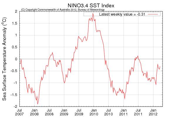
It doesn't quite look like La Nina is over, see below. Both come from the Australian weather board. So someone is not quite telling the truth.
Below 0 = La Nina
Forgive my ignorance please but... I am fairly new to oz (3 years) and even more new to kiting (first season) but what exactly is la Nina? And is there a reason it's got a Spanish name?
Refer to this thread for a discussion on el nino
www.seabreeze.com.au/forums/Kitesurfing/General/Does-El-Nino-bring-more-or-less-wind/
The BOM predicts a weak el nino for 2013. Translation, cooler water temps on the eastern seaboard, warmer land, hence convection = seabreezes
The 2011–12 La Niña reaches its end
Issued on Tuesday 27 March | Product Code IDCKGEWWOO
The 2011–12 La Niña event has ended, with key indicators returning to neutral (neither El Niño nor La Niña) levels. Climate models surveyed by the Bureau of Meteorology suggest that neutral conditions will persist until at least early winter.
Key Pacific Ocean indicators are now at neutral levels, with values similar to those last seen in August 2011. Likewise, atmospheric indicators such as cloudiness, trade winds and the Southern Oscillation Index (SOI) have also returned to near-normal values for this time of year. Despite the 2011–12 La Niña not commencing until far later than normal (spring), the decline has been fairly typical of past events, with a peak in January and a return to neutral conditions during autumn.
The demise of the La Niña does not mean the risk of wet conditions (or tropical cyclones) over Australia has ended. While sea surface temperatures around the continent remain warmer than normal and the tropical wet season is active, there remains a risk of above average rainfall over Australia.
The Indian Ocean Dipole (IOD) has limited influence on Australian rainfall from December through to April. Neutral IOD conditions are forecast for the southern hemisphere winter.
Next update expected by 10 April 2012 | print version
The Southern Oscillation Index (SOI) rose early in the last fortnight before holding around +7 for the past week, remaining within values indicative of neutral ENSO conditions. The SOI has remained within neutral values since mid to late February. The latest (25 March) 30-day SOI value is +7.1.
Sustained positive values of the SOI above +8 may indicate a La Niña event, while sustained negative values below −8 may indicate an El Niño event. Values of between about +8 and −8 generally indicate neutral conditions.
Trade winds:
Trade winds have weakened over the past two weeks. Across most of the equatorial Pacific wind anomalies are near normal, except for westerly anomalies in the far western equatorial Pacific, associated with the passage of the Madden-Julian Oscillation (see wind anomaly map for the 5 days ending 25 March).
During La Niña events, there is a sustained strengthening of the trade winds across much of the tropical Pacific, while during El Niño events there is a sustained weakening of the trade winds.
At a glance
ENSO is the oscillation between El Niño and La Niña conditions.
This climate influence is related to: El Niño La Niña The Australian Monsoon
What is it?
The term El Niño refers to the extensive warming of the central and eastern tropical Pacific Ocean which leads to a major shift in weather patterns across the Pacific. This occurs every three to eight years and is associated with a weaker Walker Circulation (see diagram below) and drier conditions in eastern Australia. El Niño Southern Oscillation(ENSO) is the term used to describe the oscillation between the El Niño phase and the La Niña, or opposite, phase.
In the eastern Pacific, the northward flowing Humbolt current brings cooler water from the Southern Ocean to the tropics. Furthermore, along the equator, strong east to southeasterly Trade winds cause the ocean currents in the eastern Pacific to draw water from the deeper ocean towards the surface, helping to keep the surface cool. However in the far western Pacific there is no cool current, and weaker Trades mean that this "upwelling" effect is reduced. Hence waters in the western equatorial Pacific are able to warm more effectively under the influence of the tropical sun. This means that under "normal" conditions the western tropical Pacific is 8 to 10°C warmer than the eastern tropical Pacific. While the ocean surface north and northeast of Australia is typically 28 to 30°C or warmer, near South America the Pacific Ocean is close to 20°C. This warmer area of ocean is a source for convection and is associated with cloudiness and rainfall.
However, during El Niño years, the trade winds weaken and the central and eastern tropical Pacific warms up. This change in ocean temperature sees a shift in cloudiness and rainfall from the western to the central tropical Pacific Ocean.
Animation demonstrating the ENSO cycle. Learn more about the Walker Circulation.
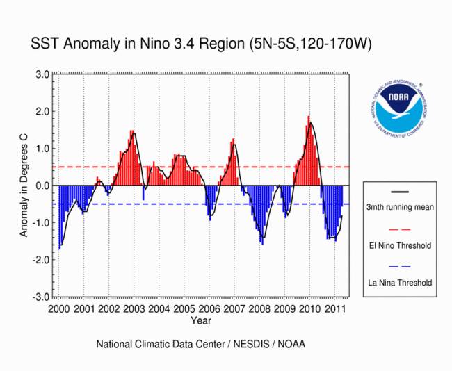
The Southern Oscillation Index, or SOI, gives an indication of the development and intensity of El Niño or La Niña events in the Pacific Ocean. The SOI is calculated using the pressure differences between Tahiti and Darwin. The following figure demonstrates the typical fluctuations in SOI over a period of 11 years. Positive SOI values are shown in blue, with negative in orange. Sustained positive values are indicative of La Niña conditions, and sustained negative values indicative of El Niño conditions.
This graph shows the values of the SOI between 1994 and 2007
How does it affect Australia?
Each phase of the ENSO has a very different effect on the Australian climate. Events generally have an autumn to autumn pattern of evolution and decay. That is, they typically begin to develop during autumn, strengthen in winter/spring, then decay during summer and autumn of the following year. These effects are described in further detail on the following pages: El Niño and La Niña.
Further information and latest updates
The following links provide further information regarding the El Niño Southern Oscillation and its impact on the Australian Climate.
El Niño, La Niña and Australia's Climate (pdf) provides further detail on ENSO and its impact on Australia.
The Latest ENSO Wrap-Up provides the latest information on the state of ENSO and the likely effect this will have on Australia.
Australian Rainfall Patterns during El Niño and La Niña Events gives further case studies for the Australian region.
More links to books, journals and related websites
Nice tech info guys - thanks for that. I'll try to digest it sometime I have time.
Problem in Perth (apparently) is all about the Leeuwin Current.
Regular cycle has this current moving offshore & southward during Spring allowing cooler water to wrap our SW coastline.
Colder water with warming land = seabreeze.
This year the Leeuwin Current has not moved. Water has remained a consistent 23 to 24 degrees around Perth which is 3 or 4 degrees above 'normal' summer temp.
For seabreeze you need cooler ocean > warmer land so with rain regularly through summer this year you also get evaporative cooling of the land. We have been copping from both ends.
Official records are apparently showing 'real' seabreeze days for this season still around 30 or so. Normal is more than 20 per mth from October to March.
If you havent noticed its not a good season ![]()
disclaimer - all above is summary of supposed experts - not trying to pretend I know it all and would love anyone to point out anything they feel isnt actually accurate.
All sounds logical to me so I tend to accept it unless I know different.
Graphs are good and can provide evidence of what ever it is your trying to prove.
However the hot chick that does the weather from channel 7 news said la Nina is gone, no further graphs are required.
As long as the gods of wind & sea follow the rules for the Coral Sea in August I'll be a happy camper.
Consistent broad reach wind - a shallow reef to follow for 2 days and a single semi-open ocean crossing day 3 - all planned around a minimal tidal influence.
Yeeeow - so stoked.
Mandurah > Perth downwind fundraiser is about to be announced.
Thats about the daily allowance we are going to have to cope with to be the first kiters ever to cross from Oz to NG.
Hey Scotty settlers beach is better spot on a low to mid tide for flat water I'm not a fan of hearsons definitely no self launch there. I always head to settlers or point samson if it's blowing from the east (winter) should start to get a few easterlies soon.
All that info came off the website I sent you.