Search for a Location
  Clear Recents
Metro
South West
Central West
North West
  Surf Cameras
  Safety Bay Camera
Metro
North
Mid North
Illawarra
South Coast
Metro
West Coast
East Coast
Brisbane
Far North
Central Coast
Sunshine Coast
Gold Coast
Hobart
West Coast
North Coast
East Coast
Recent
Western Australia
New South Wales
Victoria
South Australia
Queensland
Northern Territory
Tasmania
  My Favourites
  Reverse Arrows
General
Gps & Speed Sailing
Wave Sailing
Foiling
Gear Reviews
Lost & Found
Windsurfing WA
Windsurfing NSW
Windsurfing QLD
Windsurfing Victoria
Windsurfing SA
Windsurfing Tasmania
General
Gear Reviews
Foiling
Newbies / Tips & Tricks
Lost & Found
Western Australia
New South Wales
Queensland
Victoria
South Australia
Tasmania
General
Foiling
Board Talk & Reviews
Wing Foiling
All
Windsurfing
Kitesurfing
Surfing
Longboarding
Stand Up Paddle
Wing Foiling
Sailing
  Active Topics
  Subscribed Topics
  Rules & Guidelines
Login
Lost My Details!
Join! (Its Free)
  Search for a Location
  Clear Recents
Metro
South West
Central West
North West
Surf Cameras
Safety Bay Camera
Metro
North
Mid North
Illawarra
South Coast
Metro
West Coast
East Coast
Brisbane
Far North
Central Coast
Sunshine Coast
Gold Coast
Hobart
West Coast
North Coast
East Coast
Recent
Western Australia
New South Wales
Victoria
South Australia
Queensland
Northern Territory
Tasmania
  My Favourites
  Reverse Arrows
All
Windsurfing
Kitesurfing
Surfing
Longboarding
Stand Up Paddle
Wing Foiling
Sailing
Active Topics
Subscribed Topics
Forum Rules
Login
Lost My Details!
Join! (Its Free)

Forums > Land Yacht Sailing Construction

Iceflyer Build

Reply
Created by northdesign > 9 months ago, 25 Sep 2012
PeterVernet
56 posts
1 Apr 2013 11:18PM
Thumbs Up

LBCBUGEYE said...
It is hard enough to get out to the dry lakebed when the wind is just right. Does the tide and wind seem favorable most of the time or is that just one more variable you have to deal with?


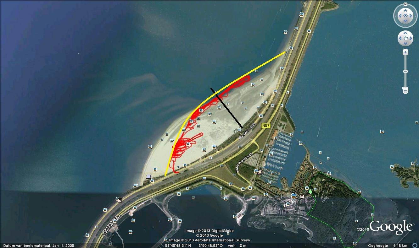
This is the beach we sail, the souhtern half under the black line.
The yellow line is as the beach is nowdays, the sand moved by wind and current a bit north.
The best sailing is North - west wind derection , shown by my track in red.
But any direction between SW and NE over the west side can be sailed.
Eastern directions then the wind is blocked by the Dam.
Starting at minimum 4 bft wind speed.


Than commes the variable we have to deal with;
the tide tabel and time window.

First check; http://live.getij.nl/getij_resultaat.cfm?page=home&location=BROUWHVSGT08&timezone=MET_DST&refplane=NAP&from=20130129

Here we see at what time the tide is how high or how low.

Just above the graphycs tells this; LAT=NAP -155
This is the beach/sand level. Under that level we can use the beach hole daylight periode.
In the mid winter ?7 hours daylight, in the mid summer ?16.
In the summer its very full with people, I sail only in the winter .

Webcam;www.natural-high.nl/webcam-brouwersdam/

Iff the water level commes up or over 155 cm in the blue collum at the right than the hole beach becomes water at shown time.
We have to wait at one hour after low tide in periodes with very high and low tides, otherwise the beach is to muddy.
So wind direction must be right and strong enough in combination with low tide.
At our coast we have very high/low tides, 2 days after new and full moon.
Almost no tide (dead tide) 2 days after firts and last 1/25.

Correct me if I am wrong, this worked so far for me.


Subscribe
Reply

Forums > Land Yacht Sailing Construction


"Iceflyer Build" started by northdesign