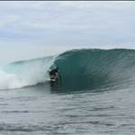
Broad reaching off the coast of NSW in the first seabreeze of the season on tuesday had me thinking of my one attempt at the Ledge to Lancelin Ocean Classic a few years ago. What a great event, pity it's only on once a year and on the wrong coast. There should be more of it. Can we use the GPS to generate more interest in downwinders?
So I'm throwing down a challenge for the coming summer. It's called Latitude racing. East vs. West. Sou'wester vs. Nor'easter. Our seabreeze is as good as your seabreeze. (I'm hoping my NSW compatriots will back me on this one)
Here's the first draft of the rules, feel free to suggest variations.
Race downwind between even minutes of lattitude, ie a Nautical mile, you must put in 3 gybes so you're not tempted to go too far off shore. Fastest transit times score most points for the series. Groups of 3 racing racing as a pack score safety bonus points. It should be pretty easy to scan your tracks for the even minute of lattitude crossings and hence transit times.
I've checked google earth. There are plenty of good courses available on the east coast. Here's a few.
Pittwater : 33deg 43' S to 33deg 44' S
Botany Bay : 33deg 57' S to 33deg 58' S
Sandon Point : 34deg 20' S to 34deg 21' S
Gerroa : 34deg 37' S to 34 38' S
Plenty on the West coast - it's so straight no treacherous headlands to worry about
ie Cottesloe 32deg 00' S to 31deg 59' S
Unfortunately I can't get my GPS to show Lat / Long in large format which would make it easy to see where you're at out on the water. But I think you'd soon become familiar with your local course and that wouldn't be a problem.
Anybody up for it?
As an example the courses at Pittwater and Cottesloe


Well Lao Shi, so far just you and me. That simplifies the scoring system![]() . Can't believe we are the only two appreciative of the pure simplicity of racing between parallels of Latitude. The nautical system is based on them after all!
. Can't believe we are the only two appreciative of the pure simplicity of racing between parallels of Latitude. The nautical system is based on them after all!
I'll take the gps when I next scope out my local course. On exposed north-south aligned coasts, in seabreezes, chop and waves will be part of deal no matter where you are. I think a time between two parallels 0 deg 01' 00", a nautical mile, apart of less than 6 minutes will be pretty good.
I like the idea.
3 people is good for the pick up and car swapping required- cos upwind is slow.
Maybe longer downwinder is needed to make it worth the car driving- remember the 25 km LOC is done in 30 minutes to 1 hour. But we could always log a few latitude, and pick the best of the run.
Maybe someone can do the realspeed programme to make it easy to select a "LXRacing" " Latitude Cross Racing"- catchy hey...) division.
just noticed this, I'm in for sure. Have not really got my head around the tech details but any excuse to blast down wind on the open ocean is good enough for me!!![]()
I'll have a crack.
I want to some downwinders this season anyway in prep for the LOC.
Like the others I'm a little fuzzy on the details but I'm sure we can work it out.
You won't get that many takers on the east coast for this unless people start changing where they sail. Based on the GPS Challenge sessions so far; very very few of them are out in the open ocean in NSW.
Usually on a strong NE seabreeze we get really nasty shorebreaks and plenty of beach current on most beaches.
Ledge Point is at 31deg 06' 27.36" S
Lancelin pub is at a latitude 31deg 00' 53.43" S
A difference of 0deg 05' 33.93"
The subtraction is not easy, which is why after a bit of head scratching I suggested racing between even minutes - so we could do it using the raw tracks - position vs. time - with no real need to get into computer programming.
So the LOC winners cross two circles of latitude separated by 05' 33.93" in 30 minutes, that's 5minutes 23sec for each minute of latitude. (two different meanings for "minutes" confusing all right!)
So a time of 5minutes 20 sec is what you'd aim for in latitude racing if you hoped to be on the winner's podium. That's what east coasters should be aware of when they go over. I thought I'd go reasonably well? Well I got to the pub in just over an hour, and even then I didn't round the last cray boat.
Sailing over one minute (1') of latitude you should be able to sail back without necessarily needing a car shuffle. If the idea goes further there could be bonus points for 2', 3' or 4' downwinders if you like.
For example if you were practicing from Ledge Point you'd sail down wind for about 10 minutes sail back and be looking for these sort of numbers in your downloaded track file
time .................................................position
12hr13min12 sec ............................31deg 06' 00.00".........115deg 22' 12.89"
12hr13min14 sec.............................31deg 05' 59.XX".........115deg 2X' XX.XX"
.etc
every 2 seconds etc etc
.etc
12hr18min36sec..............................31deg 05' 00.00'...........115deg XXXXXXXX
etc.
etc
(the Xs are not important in the calcs)
Now I'm hoping the lines of zeros in the position column stand out when you scan the track file and you can see that you covered 0deg 01' 00" of latitude from time 12hr13min12sec to 12hr18min36sec ie a time of 5min 24 seconds - you're on the pace.
Because the east and west coasts run roughly north south and the seabreeze come in at 45 degrees to coasts, there is a certain equivalence and the east and west coast playing fields are level.
Trouble with inviting the Vic and South Aussies to take part is that they'd have to use longitudes as the simple measure of downwind distance. And unlike latitudes, longitudes aren't parallel, the distance between them varies. That could be fixed with some clever programming though.
(btw there's only two "t"s in latitude)
Good to see some interest from WA![]()
I am confused?![]()
Happens easily.
I just reviewed my LOC track from last year and the lat from Realspeed puts the start at 31.109 and GE is 31 06 31
How do I get the settings to be the same? Had a look in options but can't see anything.
Why not just have a 5 mile time? Would make things simple and it doesn't have to be north - south so would include more people. It would have to be 5 miles between any two, and only two track points, ie not 10 half mile runs strung together.
Perhaps it could include a requirement for a minimum number of gybes but thats going to be hard for a software program to recognise.
5 miles would means it would have to be open ocean as I don't know of any 5 mile speed strips in aus?? Also down wind sailing would obviously be the quickest way.
5 miles down wind sound good to me![]()
My 2c
Very sensible there Ian1, it's also easy to set up in Realspeed... it's just a new category based on 5 x 1852 metres which is... ummm... *reaches for calculator* *no hang on I can do this*
9260 metres.
(double checks on calculator to make sure)
There could also be a gentleman's agreement that you must stay within sight of land at all times, which is pretty close to the LOC. Some of those outside marks are a long way offshore!
Just stay safe people, I'd recommend wearing a buoyancy vest if doing this.
Not to be a wet blanky, but while the coasts may seem to run north/south, they are really a crinkly jig-saw puzzle shape.
Wello, for example, faces due north, but sails best on a westerly, producing a north/south track. and Currumbin is not far off due north, but is mostly sailed in a nor-easter at all sorts of funny angles depending on inclination.
The 5 mile idea is much simpler.
Yes that would achieve the same thing Ian1, with the advantage of not being dependant on coast alignment. And providing someone could program the computer be a breeze to deal with.
I'd argue it's not quite as "pure" as racing between latitudes, but that's just me.
If someone goes to the trouble of reprograming the onboard gps software, a big fonts option on the latitude display, or for Ian1's suggestion big fonts on a distance made good display, so you could see where you are at would be great.- You don't want to go too far downwind if you're sailing back. Although if it was latitude based, the start & finish points are fixed, you'd soon learn to line up landmarks on the shore and wouldn't overshoot.
Lau Shi 31.109 degrees looks like 31deg 6' 31" in decimal format.
0.109 * 3600" = 392" = 6' 32"