ecmwf is predicting a strong east coast low next week around thu/fri/sat. fingers crossed.....
other models don't agree.
I hope it comes off. better than these wimpy 20 knot northerlies. ![]()
been a while since we had a good 30-35knot session.
probably too good to be true anyways.
ecmwf, breaking down curtains since 1994
damn!~ not fair.
ecl's are so unreliable at best. could form anywhere or not at all.
just had a look at the tides. is looking good tide wise but may need to be an 11am kick off.
i'm with you. itchin for a SE'ly as well.
Select to expand quoteGestalt said..
just had a look at the tides. is looking good tide wise but may need to be an 11am kick off.
i'm with you. itchin for a SE'ly as well.
4am tom if ya keen ![]()
![]()
You guys are physic - was woken this morning by the blinds rattling, looked at the clock and its 4am......
of interest I thought these 2 images show synoptically what we need for strong northerlies.
first image shows a high just off the nsw coast. so winds are strong to the SW where the cold front is.
as the high moves over towards NZ the cold front pushes NE and creates the killer northerlies we've been having. the stronger the high is over new Zealand the better the northerlies.
then as the cold front passes the coast we get the SE winds the next day. sometimes, the cold front turns into an ECL as it hits the coral sea. which is the image I posted above.


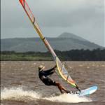
Now that was good to clear the cobwebs...........
A great arvo at VP, good bunch of guys as well.
Time for a home brew - CHEERS!!
nice on greg,
missed it, will miss this Friday also because of work commitments. looks like the ECL will form too far off the coast now to effect us to any great deal but Friday is still pumping SE then it's over.
so northerlies it is