Weather | Buy&Sell | Forums |  |
Weather | Buy & Sell | Gallery | Forums | |
TROPICAL DEPRESSION 13F ANALYSED CENTRE [998HPA] NEAR 14.5S 168.5E AT
110600 UTC SLOW MOVING. POSITION FAIR BASED ON IR/VIS IMAGERY WITH
ANIMATION AND PERIPHERAL OBSERVATIONS. SST AROUND 30 DEGREE CELSIUS.
CONVECTION REMIANS PERSISTENT IN THE LAST 12 HOURS. ORGANISATION
REMAINS FAIRLY GOOD. SYSTEM LIES ALONG A MONSOON TROUGH AND UNDER AN
UPPER RIDGE, IN A LOW TO MODERATE SHEAR ENVIRONMENT.
GLOBAL MODELS HAVE PICKED UP THE SYSTEM AND MOVING IT WESTWARDS OVER
THE NEXT 24 TO 48 HOURS WITH SOME INTENSIFICATION. POTENTIAL FOR THIS
SYSTEM TO DEVELOP INTO A TROPICAL CYCLONE WITHIN THE NEXT 24 TO 48
HOURS IS LOW TO MODERATE.
This is a interesting, I live in Mackay and plan to travel to Brisbane on Saturday (the 20th) and then be in Burrum Heads from Tuesday.
I think I could be securing the house and maybe heading north?? for a few days to dodge the cyclone and then south...who knows but it will be interesting towards the back end of next week....might be time to throw the outdoor furniture and shade sails in the pool again and board up the front of the house.
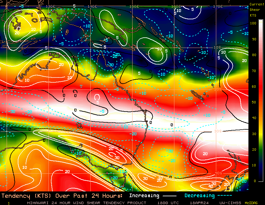
can you explain what the windshear chart means....I take it cyclones like to follow minimum to negative shear??
hi bluedog,
i'm no expert with cyclones. from what i understand you are kind of on the money.
however cyclones don't follow shear. they are steered by mid to upper weather systems i believe. to survive a cyclone needs a low leve lof shear or the top just gets ripped off and the whole thing falls apart. so low shear values are good and high shear values are bad as you have said.
i think however if a cyclone gets very big it can start to influence the conditions around it and have an effect on shear.
what to do is a hard call. cyclones tend to wander around when they hit the coral sea and time frames and tracks can vary wildly.
also the windshear map above is potential wind shear. i think it is w=orking 6 hrs ahead. it helps predict whether conditions for intensification are favourable or not.
p.s. i found this link and it is very informative.
www.wunderground.com/education/shear.asp
or follow this link for up-to-date banter on the future cyclone...http://forum.weatherzone.com.au/ubbthreads.php?ubb=showflat&Number=843062&page=27
still early days but most models are beginning to align and point towards a possible coastal crossing between gladstone and mackay around sunday........
maybe......
I am starting to feel more comfortable. The bom have the wind model showing that it will be almost a direct hit on Mackay. As they have changed the forecast ever day so far surely it can't hit Mackay (damn, I have probably just locked it in) this far out.
Sailing on the 35ft yacht in the long offshore race off Mackay this weekend will either be very rough or cancelled.
I have seen one model saying Cooktown as a depression.....very hard to tell but I might start getting the ply out soon.
i don't envy you at this point blue dog, who knows which way things will go. cyclones are so unpredictable........
Heading straight for Yeppoon (Capricornia) on latest BOM predictions. Looks like I'll be rigging the Ezzy 1.0metre kids rig and 20litre boogie board.
^ my old man was a rocky boy and doesn't have anything positive to say about cyclones. ![]()
have experienced a couple of cat1 cyclones myself but other than windows bowing, trees falling over and a few roofs dissapearing not much else really happened. oh, that's right, everything got destroyed by floods. ![]()
still was an experience and a half and got days off school.
my favourite cyclones stay offshore and give me 40 knot winds to sail in,
but cat 3-4-5 i'd just board everyhting up then pack the car and leave. ![]()
i notice now the shear map is starting to roll out the red carpet. showing decreasing shear around the coast.
I remember the cyclones on the GC in the mid/late 60's when we got the day off school to bag sandbags on the Spit then deliver them by truck to one of the first high rise units on the beach, just south of Surfers. That was when Surfers Paradise had houses along the eastern side of the front road, they all got washed into the sea. We lived at Main Beach and it was pretty scary with the wind and flooding that came with them.
MEMORIES........
My memories of clonics in the 70's revolve more around the rain depressions that followed, causing massive flooding and cutting roads for days.
I do recall a few nights spent with taped up windows and flashlights at hand, but in Bundaberg, we never really got a direct hit, as they tended to bounce off Fraser Is.
We did get some very big surf though, and there is a beach there called Mon Repos, which would hold the swell rather than closing out. Some epic surf conditions in my late teens that I remember.
As Gestalt said, wind conditions are best on teh edges though, once you get toward the middle, it just gets gusty and crap.
Looks like the forecast has changed and the cyclone is going to cross land north of Mackay now, maybe around Airlie Beach. Not sure whether to be scared or excited! I think Saturday will be spent getting everything in the shed up off the floor in case it floods. Then down the beach with my pink boogey board and shred!
Squid,
You guys are welcome to host Ului.
Amazing how quickly forecasts change. Next update will probably have it crossing land between Coffs Harbour and Sydney.![]()
Category 5 damage to my accommodation (the one in the tree) and offices, exploration camp located at Indee station south of Port headland, 1 death(on site, 3 total). serious carnage. thankfully the homestead was built to a cyclone standard as the two previous ones had been totaled in other cyclones. Brick work cracked and moved but the roof stayed on.


seems that ului is weakening..... i guess it stayed in one place to long and lost it's steam. still it's cat3 which is strong.
to throw a dart at the board i'm going for a cat2 crossing at home hill.
Still holding off on taking down shade sails (pretty heavy duty) and putting up the ply on the front of the house...hoping for a continuation of the northward trend. I like the UKMet model the most (not so much for Innisfall again).
May even get out for a windsurf Sat morning......should be well overpowered on my 4.7.