It always amazes me the difference in seabreeze forecasts and those from the BoM. Why is it so?
i think the bom forecasts are issued for coastal waters up to 60 knots offshore. maybe the seabreeze ones are intended for more inshore areas?
Nope....BoM forecast is for South East Coastal areas. The places where we kite.
No satisfactory explanations as yet....
Methinks BoM has human scientists, data and computer models to predict with and seabreeze is just computer models.
The next few days will tell who is right.
dave i don't think you get it so let me simplify it for you- up to 60nM from the coast means from where the water starts to 60 nautical miles out to sea. high seas forecasts cover the areas past that.
coastal waters forecast is not for inshore waters only (where we kite), its meant to cover all possibilities for conditions up to 60 knots out. once you get a few miles off the coast the weather can get very different.
It's obvious! One of the moderators is planning on going out at the sunshine coast early this week and doesn't want to be disturbed.
Or..... seabreeze is beach forecast and BOM is coastal ie 60Nm out
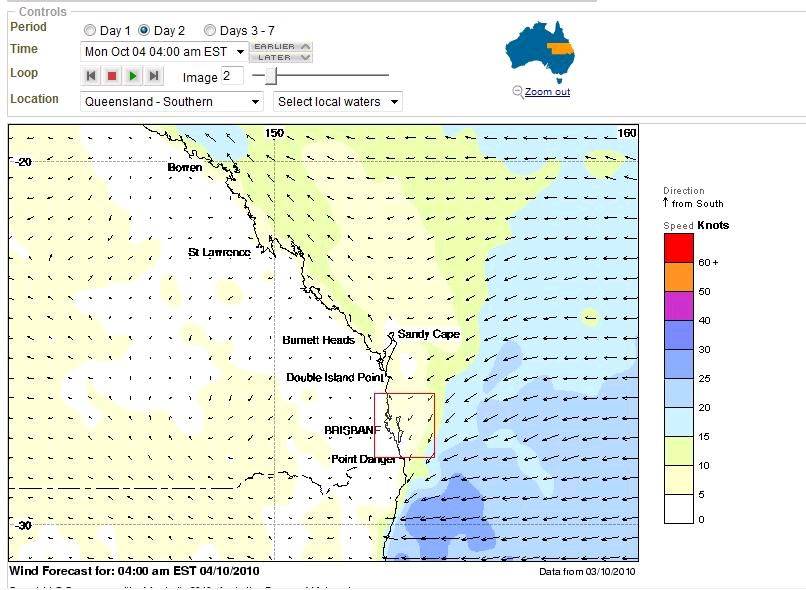
Here is the marine wind forecast. As you can see SFA on ther beach, 325kts a little way out to sea. Time to get a boat.
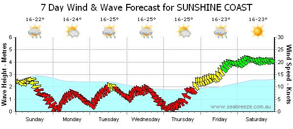
Lets see how acurate the prediction is for the sunny coast for next weekend.
Or is it another 7 day away "its gonna be on lads" guess!!
pure an simple one of them ...was on drugs an its not the first time this has happened.
The BOM has recovered from the wk end bender an corrected there forcast !
Coastal waters forecast
Double Island Point to Point Danger and Moreton Bay
Issued at 4:36 am EST on Monday 4 October 2010
Southeast Coast Waters, Double Island Point to Point Danger:
Strong wind warning cancelled.
Monday until midnight: Wind: S/SW winds 10/15 knots, tending N/NE 15/20 knots over offshore waters south of Cape Moreton in the morning. Inshore afternoon NE seabreezes 10/15 knots. Sea: 1.2 metres, reaching 1.7 metres over offshore waters south of Cape Moreton in the morning. Swell: E 2 to 2.5 metres. Isolated showers.
Tuesday: Wind: NW/SW 5/10 knots, tending N/NE 10/15 knots inshore in the afternoon. Sea: 1.2 metres. Swell: E 2 metres. Isolated showers.
Wednesday: Wind: SE/NE to 15/20 knots.
WEATHER FORECASTING!!!!!!!!!!
The science of guessing with the latest technology
and information!!!
I'm still confused... If the forecast is up to 60 n miles out to sea does that
mean I have to wear a pfd or not ?