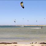
What is the City of Rockingham thinking? This is about 50 metres of the sandbar they are dredging.
1. Kiteboarding area will be seriously impacted with that ugly dredger in there for the next few months
2. Environmental impact considering it is Tern Island sanctuary zone
3. Stinky sludge will be dumped on the beach closer to Warnbro, say goodbye to the beautiful white beach

Select to expand quoteNutdip said...
Can anyone remember the last time it was dredged?
They dredged it when I was living around there in 05 or 06 I think, that was what changed the shape to make that perfect E-W sandbar.
You can't fight nature...
Spoke to Council yesterday, they were very forthcoming with information which was great.
Rockingham dredged the channel two years ago. Apparently the Tern island has grown by 50m since then. Those Nav markets are pretty close to the island now.
The City hope that these current works will give them a further 3 years respite.
They have concerns about the health of the actual pond itself and reckon it needs a flush but this it would involve DPAW and other coastal agencies to get on board and the City knows they are pushing ** up hill here.
The shallow bit at the Western portion appears to be growing as well.
Sand is coming from the islands to the south apparently, pretty cool to see how nature works here. See the Red arrow in the image. Dont know if the pond will fill up in 10 years. As mentioned above, who can fight nature!
End of the day, just be careful for the next couple months.

This image was taken in September 2013, so 3 years ago.
Forgive the dodgy mark up...

Yeah you definitely can't fight nature. I grew up in Safety Bay and the spit used to be an island a lot further out with cray boats anchored in-between the island and shore. We used to swim across to the island and hang onto the anchor chains for a rest half way. This was back in the late 80's, early 90's so it hasn't taken that many years in the scheme of things for the island/spit to completely morph and change so much.
The dredging is going to prolong the spit if anything. If left untouched it's only a matter of time until the spit joins the mainland and fills in with 'The Pond' being no more.
Sorry for spamming up this thread. This stuff is pretty interesting and nearmaps is awesome!
take a look at the pond in May 2008...
There was no "Pond"...
If anyone wants to waste time, check this thesis report out. i just googled it (randomly know the bloke that did it too). talks about the pond and coastal sand movement and erosion. There are historic photos in his report.
www.web.uwa.edu.au/__data/assets/pdf_file/0007/1637323/Hollings_2004.pdf


since I agree it is very interesting, here are some aerials pre-nearmap era.
first is 2004 - "sshhhhh...sweet kiting spot starting to form, don't tell anyone."
second is 1978 - "that sandbar is a navigation hazard"
thirdly is 1954 - "what pond?"
always interesting to look back prior to shouting "we need to save xxx, it's sacred, stop messing with nature..."
but I digress.
hopefully the dredge doesn't cause crew too much hassle. worth noting that the geologists basically believe that in say another 50-200 years, this bank just becomes one with the shoreline and it will look like 1954 basically again. but there could be back to back cyclones or a crazy storm year next year and it happens in 5. prepare yourself!! ![]()
cheers.
You can also see a bit in those photos that the sandbar to pengo's used to be out of the water, which was pretty badass, butter flat water that dropped off to quite deep for when you messed up, and was awesome to jump over!
WHAT???
The City of Rockingham is going to dump the stinking dirty waste from the dredging all over the swimming beaches. Last time they dumped it on the dog beach and it is still there, its black dirt and your feet come out of it filthy and I have seen kids playing in it.
Send a email to the city and your local member, don't let them do it!!!!
Nah man think of all those bogan boat owners...how are they going to get their boat, packet of winfield red and the carton of emu export off shore to rape the oceans ??
Not at all mate.. No where near it.
I just called them and spoke to the coastal engineer