Forums > Kitesurfing   Newbies / Tips & Tricks

How to read clouds or visible weather?

Reply
Created by deXtrous > 9 months ago, 9 Dec 2011
deXtrous
NSW, 451 posts
9 Dec 2011 7:54PM
Thumbs Up

Hey folks.. I've never quite learnt how to read physically visible weather to determine if a squall is coming or if the wind will soon drop, so I ask you guys on behalf on myself and everyone else (I'm sure there's a bunch) who would benefit from learning.

Cheers, I understand it'll be a bit hard without pictures but go for it if you have the knowledge.

NickT
WA, 1094 posts
10 Dec 2011 12:19PM
Thumbs Up

Grey and nasty, generally is. Cumulous and Cumulo Nimbus when associated with fronts are the ones to watch out for I think.
Google Microburst.

dafish
NSW, 1637 posts
10 Dec 2011 4:55PM
Thumbs Up

there is a saying, "if it looks nasty, then it is."
If you ever see a sky go green, prepare yourself for the worst.

dave......
WA, 2119 posts
10 Dec 2011 2:45PM
Thumbs Up

All places are different, If a black cloud is coming, go in and wait it out. In fronts, it will generally slowly pick up until the front hits. The wind changes direction as its raining and up/down drafts are common, after the rain has stopped, usually the wind dies down for about 1/2 an hour, before it slowly picks up again for the next cloud band that follows. Not good to kite in.

With regard to a seabreeze in Perth, when those whispy clouds go all the way to rottnest I dont care what the forecast says, like friday here it was supposed to get to 20-25 knots, NO way. Its troughed out at the seabreeze will reach 15 knots maximum. A really good newbie question. others are sure to add more about your local conditions..

Cumulo-numbus clouds look anvil shaped and have severe up/downdrafts, they dont occur in WA or rarely over East if at all, they occur in the US and Europe.

TurtleHunter
WA, 1675 posts
10 Dec 2011 6:15PM
Thumbs Up


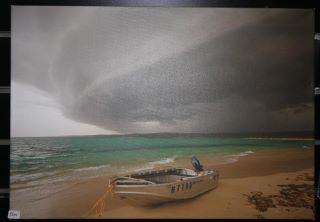
This would be a line squall don't have your kite up when one of these hit. For that matter don't even leave a kicker on the beach

dafish
NSW, 1637 posts
11 Dec 2011 12:12AM
Thumbs Up

^
I would run from that....or at least bury my kite with sand until it passed and i crawled out from my van....nice pic

flybywire
NSW, 50 posts
12 Dec 2011 3:53PM
Thumbs Up

This is a photo from yesterday in sydney, large thunderstorm rolling in over bondi beach. we had 10 Knot Ne and it changed to 25 knots from the south for about 10 mins. then absolutly no wind all afternoon.

dafish
NSW, 1637 posts
12 Dec 2011 4:23PM
Thumbs Up

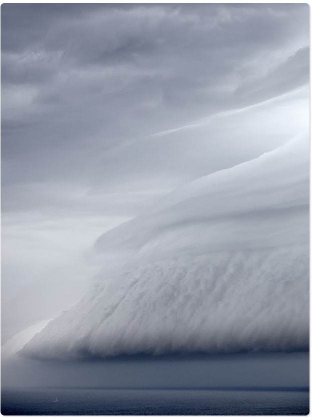
looks like a big brush coming to sweep up everyone in it's path! I can't get enough of seeing nature do her thing.

Captash
NSW, 29 posts
12 Dec 2011 5:21PM
Thumbs Up

dave...... said...


Cumulo-numbus clouds look anvil shaped and have severe up/downdrafts, they dont occur in WA or rarely over East if at all, they occur in the US and Europe.


Dave has spot on advice - the colour of the sky tells you alot.

Generally speaking, the darker a cloud band is the more energy it holds and the greater the wind sheer it may bring with it. Best to go ashore and wait for a front to pass. Beware a sudden change in wind direction ahead of a front, it usually signals much stronger winds are on their way.

One correction, Cumulo-Nimbus are reasonably common. Whilst the 'classic' shape of a Cumulo Nimbus cloud is an anvil, basically any cloud that is taller than it is wide is classified in this type, and literally means a 'heap of rain'.

A career spent dodging TRS's and sailing through storms at sea has given me a huge respect for storm fronts.

dave......
WA, 2119 posts
12 Dec 2011 6:00PM
Thumbs Up

^^^^^Thanks dude for the compliment

Captash said...

Select to expand quote
dave...... said...


Cumulo-numbus clouds look anvil shaped and have severe up/downdrafts, they dont occur in WA or rarely over East if at all, they occur in the US and Europe.


Dave has spot on advice - the colour of the sky tells you alot.

Been sailing in Manly juniors when little, surfred, windsurfed and kitesurfed since 2003. Yesterday, BOM "suggested it was going to be 20-30 late afternoon, it didnt get above a 13-15knot average and I was ready to go, at 4pm it was still troughed out and I drank beers instead. The BOM bases their predictions on 4 years worth of data through mathematical modelling which is pure "Chaos theory", therefore it has a large bell curve. In medicine you must have a P value of 0.5%. They dont have that luxury when it comes to weather. In winter I kite for 30-45 mins and then things will change radically.

IF IN DOUBT, DONT GO OUT!, you cant kitesurf tomorrow if youre all busted up. WAKSA's motto is C.L.E.A.R

R: respect other kiters, keep a safe distance, respect other beach users, they are scared of kiters, Respect local rules, Respect the conditions especially big surf if youre not from a surfing background, Respect the weather.

When there's a 15 knot gust variance you wont have a good kite and its potentially dangerous unless you are intermediate-advanced, It will be a crap kite and there's better things to do. Become a kite adrennalin user, Not a kite adrenalin junkie.


juicerider
WA, 790 posts
12 Dec 2011 8:01PM
Thumbs Up

dave...... said...
[
Cumulo-numbus clouds look anvil shaped and have severe up/downdrafts, they dont occur in WA or rarely over East if at all, they occur in the US and Europe.

B.S.
There is one over my house right now

dusta
WA, 2940 posts
12 Dec 2011 10:54PM
Thumbs Up

awesome lightning show over perth atm . ****ing wife wont let me drive down to the beach to watch it

Westy27
QLD, 8 posts
13 Dec 2011 9:44AM
Thumbs Up

flybywire said...

This is a photo from yesterday in sydney, large thunderstorm rolling in over bondi beach. we had 10 Knot Ne and it changed to 25 knots from the south for about 10 mins. then absolutly no wind all afternoon.


Is that yacht sailing right into it? Wouldn't catch me doing that even if it did only end up being 25 knots...

Doudou
WA, 46 posts
13 Dec 2011 6:09PM
Thumbs Up

As my Dad told me when I was sailing with him as a kid : "Most cloud are as bad as they look"
If the cloud looks scary... they there is a very good chance being under it will be too

TQ
5 posts
15 Dec 2011 10:26PM
Thumbs Up

Probably a good idea to be out of the water, with kite safely packed away.

Taken at Port Hedland, February 2011.


hamburglar
ACT, 2174 posts
18 Dec 2011 1:12AM
Thumbs Up

wheres the waves?

TQ
5 posts
18 Dec 2011 6:36PM
Thumbs Up

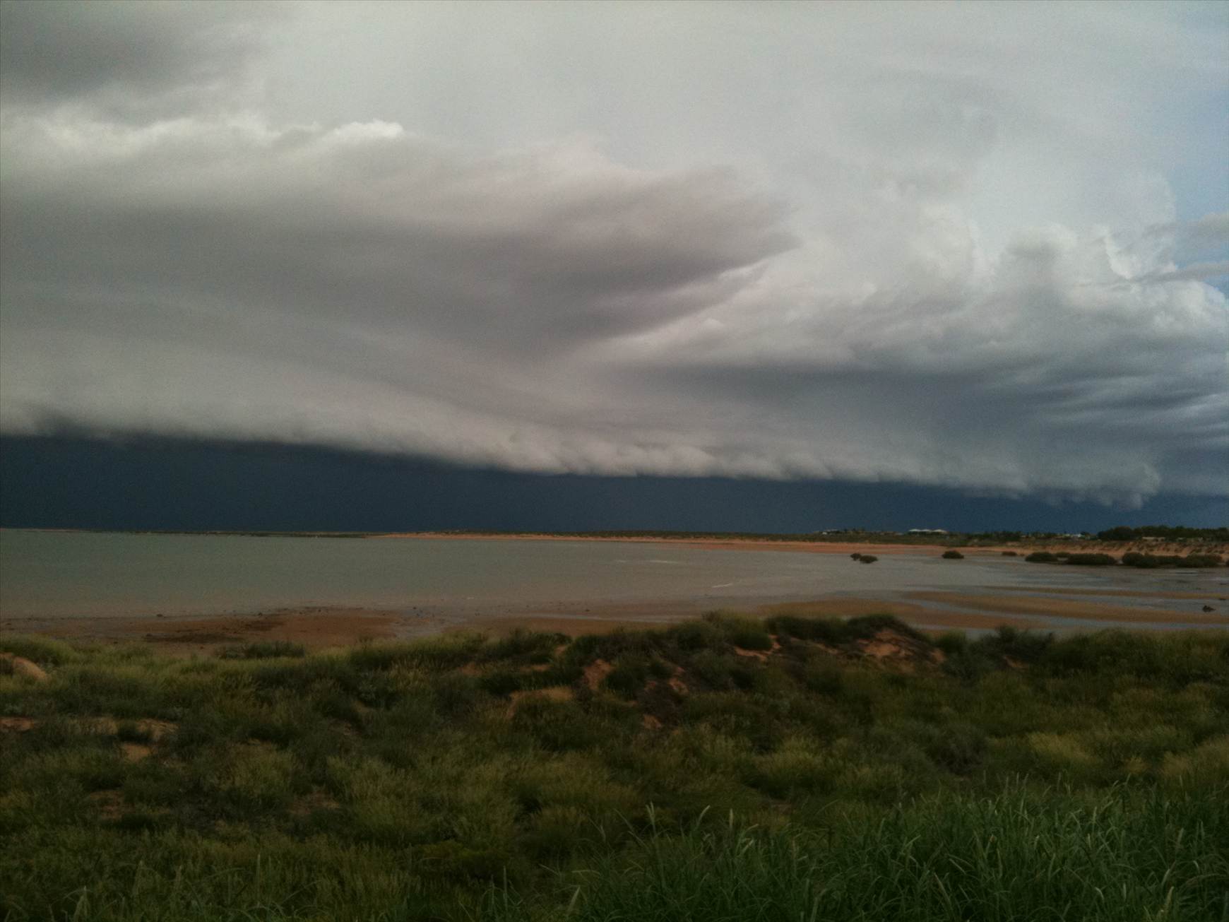
@ hamburglar....Unfortunately the Port Hedland coastline faces North/North West and misses out on any significant swell activity from the Indian Ocean.

There are small windwaves around the corner at the Spoil-Bank.

@ deXtrous....the Bureau of Meteorology has some excellent material on the subject. They have a great booklet on severe weather and good cloud recognition charts. Drop into your local office, they appreciate visits from 'weather nuts'.


Subscribe
Reply

Forums > Kitesurfing   Newbies / Tips & Tricks


"How to read clouds or visible weather?" started by deXtrous