So there I was motorsailing down the shipping channel (Port Phillip Bay), not a soul around. It's blowing 10-15kn about 30deg off the starboard bow.
I'm running the route on the autopilot that I set up quite a while ago on the Raymarine C80 Chart Plotter at the helm. I have waypoints set about 50 metres off each channel marker. The Raymarine runs Navionics charts updated about 4 years ago.
I've run this route more than 20 times before, and I'm on the leg from Channel Marker No 14 to the next waypoint at No 12, a distance of approx 1.2nm.
Since Nos 14, 12 & 10 form a straight line, I decide by using 'Advance Waypoint' to skip the No 12 waypoint and go to the No 10 waypoint.
This will give me time for a bit of a break down below from the cold and wet cockpit before I have to come up and set the next waypoint on the Raymarine when we get to No 10
Down below, I have my iPad running iNavx with Navionics charts (updated about 2 months ago) on the table in front of me.
Besides the chart, iNavx displays my track, COG, SOG, depth, true & apparent wind speed & direction, AIS, etc, so I've got a reasonable handle on what's happening.
The wind is now more like 15-18 knots.
I'm looking at the screen and seeing I'm on track with nothing near me when... BANG!!
The whole boat shudders and iPad and coffee flies off the table, other stuff ends up on the floor and I fly up to cockpit in less than a second head full of "what the hell's happening ????!!!!".
What the hell happened was I'd just driven head first into Channel Marker No 12 at 5.5 knots!
After the flurry of establishing I've not been holed so not in danger of sinking then getting the boat under control, getting the headsail down manually because the furler is smashed, I try to understand what happened.
It took a while, but it comes down to this - the Navionics chart on the iPad does NOT show the No 12 Channel Marker, the version on the Raymarine C80 Chart Plotter DOES show the No 12 Channel Marker!
I also have the Navionics iPad app, and it DOESN'T show No 12 either.
I also have iSailor on the iPad and it DOES show No 12.
I often skip waypoints and have never had a problem before, but what happened this time was, being close hauled like I was, the boat can tend to have some weather helm and apparently the autopilot was not able to keep the boat on track, so I have accumulated enough leeway to end up colliding with No 12 - but not enough to trigger an "off course" alarm on the autopilot.
Obviously, if No 12 had been showing on the iPad, I would have seen it approaching and taken appropriate action.
As far as damage is concerned, headsail furler, pulpit and bow roller are severely damaged, but I consider myself very lucky - it could have been a lot worse.
Naturally, this episode raises some questions including the integrity of charts other than the hard copy originals.
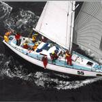
 Typical Channel Marker - I think the one I hit was even bigger!

Navionics Chart on IPad iNavx.

iSailor on iPad Chart
And yes...I do know about the warnings and disclaimers on these navigation apps.
So...any thoughts?
regards,
Allan
So let me get this right - you were heading down the shipping channel and not keeping a lookout? ![]()
Select to expand quotesydchris said..
So let me get this right - you were heading down the shipping channel and not keeping a lookout? ![]()
My first sentence includes "not a soul around", so what do you think?
Must have scared the be- jesus out of you, good to hear your still floating and ok
I'm glad your're OK Datawiz, although it's ironic that the 'data' part of your name is what let you down here ![]() .
.
All things considered, your navigation system let you down in a surprisingly accurate manner. You couldn't replicate that in a hundred years.
It's as if your electronic charts knew on a deep digital level that there was a marker there and the internal mind of the machine wanted to know for certain.
I'd put this down to life and wouldn't beat yourself up over it, although it sounds like you will be in the can for a few thousand dollars here.
On closer inspection, is there any structural damage to the bow? Is there a collision bulkhead upon which the taping may be cracked?
Select to expand quoteAshleyM said..
I'm glad your're OK Datawiz, although it's ironic that the 'data' part of your name is what let you down here ![]() .
.
All things considered, your navigation system let you down in a surprisingly accurate manner. You couldn't replicate that in a hundred years.
It's as if your electronic charts knew on a deep digital level that there was a marker there and the internal mind of the machine wanted to know for certain.
I'd put this down to life and wouldn't beat yourself up over it, although it sounds like you will be in the can for a few thousand dollars here.
On closer inspection, is there any structural damage to the bow? Is there a collision bulkhead upon which the taping may be cracked?
Thanks for your thoughts Ashley.
Given the belt and braces approach I usually take to my boating, it's almost ironic I got caught out by a 'gotcha' such as a missing data point on one of my 4 navigation apps :(
No, I won't beat myself up over it, but lessons have been learned.
As for damage - trashed pulpit, damaged furler and bow roller at right angles. Given a $2000 insurance excess, I'm in the process of DIY repairs.
regards,
allan
Sounds like it was all FRED'S fault. You know FRED don't you? Frigging Ridiculous Electronic Device. Also sounds like you had 3 or 4 of them going at once. That would be confusing for me.
I don't think you have done anything particularly wrong but I think the timing of our trip below could have been better.
You knew you were approaching mark 12 so delaying the trip below till just after you had cleared it might have been better.
Even if you had strayed out of the channel, there is still plenty of water before you are likely to ground.
As with all these types of incidents, there is a lesson to be learnt in there somewhere.
Glad to hear there was no loss of life, limb or vessel.
Now as this was an incident involving a vessel and property belonging to the Melbourne Port Authority and damage suffered is in excess of $1,000, you will no doubt have reported the incident to abovementioned authority within 24 hours of the incident. ![]()
![]()
As skippers, everything that happens on our boats is our fault - especially if you run into a nav marker, they don't run into you so you can't begin to blame them. If it is day - you keep a lookout, if it is night you slow down and look out for the lights. If there are no lights you don't go in the channel. If there is no visibility then you certainly don't use the channel. Don't blame the software for accidents like these- this is due to a lack of a lookout and misunderstanding of the concept of error circles.
Datawiz - I think you are very socially minded to put this up. It goes to show that multiple computing devices can perpetuate a single error. But it also goes to the whole reason for nav markers. Port authorities will and should change the position of nav markers to show the position of ever changing shoals. The ability of charts, of any kind, to keep up with any changes is limited so it is always prudent to use the nav programs as a guide only - to be used to locate yourself to within a rough area. Then precise navigation is done by eyeball and other means. New markers may be installed and old ones removed and it will take time for a chart to reflect the new reality - so we have to constantly check for ourselves to see if the chart is correct. Charts are guides, reality is there for us to see with every means possible.
Expecting nav software to be highly accurate will cause pain for users eventually. Recently a cat was lost in the Pacific when the owners plotted a course without allowing for even the smallest error in course, and they ended up losing their boat. Incredibly dumb but seemingly quite common. Use electronic aids as guides but not as truly accurate representations of the real world, which they never can be. The ocean doesn't care for our excuses and stopping using good seamanship because it is cold and rainy is still bad seamanship. One other important lesson here - have your nav gear accessible and viewable from the helm and make sure you can get dry and comfy in the cockpit under the dodger. Then you don't have to go inside to do your navigating in busy areas.
Good luck with the repairs.
Phil
Select to expand quoteKankama said..
As skippers, everything that happens on our boats is our fault - especially if you run into a nav marker, they don't run into you so you can't begin to blame them. If it is day - you keep a lookout, if it is night you slow down and look out for the lights. If there are no lights you don't go in the channel. If there is no visibility then you certainly don't use the channel. Don't blame the software for accidents like these- this is due to a lack of a lookout and misunderstanding of the concept of error circles.
Datawiz - I think you are very socially minded to put this up. It goes to show that multiple computing devices can perpetuate a single error. But it also goes to the whole reason for nav markers. Port authorities will and should change the position of nav markers to show the position of ever changing shoals. The ability of charts, of any kind, to keep up with any changes is limited so it is always prudent to use the nav programs as a guide only - to be used to locate yourself to within a rough area. Then precise navigation is done by eyeball and other means. New markers may be installed and old ones removed and it will take time for a chart to reflect the new reality - so we have to constantly check for ourselves to see if the chart is correct. Charts are guides, reality is there for us to see with every means possible.
Expecting nav software to be highly accurate will cause pain for users eventually. Recently a cat was lost in the Pacific when the owners plotted a course without allowing for even the smallest error in course, and they ended up losing their boat. Incredibly dumb but seemingly quite common. Use electronic aids as guides but not as truly accurate representations of the real world, which they never can be. The ocean doesn't care for our excuses and stopping using good seamanship because it is cold and rainy is still bad seamanship. One other important lesson here - have your nav gear accessible and viewable from the helm and make sure you can get dry and comfy in the cockpit under the dodger. Then you don't have to go inside to do your navigating in busy areas.
Good luck with the repairs.
Phil
Thanks for the lecture Phil.
Unfortunately, it apparent that you have not read my post as carefully as I constructed it.
In your post you have made several incorrect assumptions which will become evident when you re-read my post carefully.
I don't intend to point these out, since my post was not an invitation to criticise, but rather to show others how a combination of my human error, environmental circumstances and assumptions combined to cause an accident.
One of the key incorrect assumptions I made was that the Navionics chart on the iPad was the same as the Navionics chart on the Raymarine at the helm (which DID show No 12).
As far as the veracity and accuracy of the Navionics chart (at the helm) goes, on reflection I calculate I have traversed the same route more than 100 times in the past 5 years, and never was confronted with a dichotomy between my eyeballs and the chart.
Having responded to your post, I do not intend to respond further - or to anyone else who offers anything other than objective, constructive input.
regards to all
allan
Select to expand quoteDatawiz said..Kankama said..
As skippers, everything that happens on our boats is our fault - especially if you run into a nav marker, they don't run into you so you can't begin to blame them. If it is day - you keep a lookout, if it is night you slow down and look out for the lights. If there are no lights you don't go in the channel. If there is no visibility then you certainly don't use the channel. Don't blame the software for accidents like these- this is due to a lack of a lookout and misunderstanding of the concept of error circles.
Datawiz - I think you are very socially minded to put this up. It goes to show that multiple computing devices can perpetuate a single error. But it also goes to the whole reason for nav markers. Port authorities will and should change the position of nav markers to show the position of ever changing shoals. The ability of charts, of any kind, to keep up with any changes is limited so it is always prudent to use the nav programs as a guide only - to be used to locate yourself to within a rough area. Then precise navigation is done by eyeball and other means. New markers may be installed and old ones removed and it will take time for a chart to reflect the new reality - so we have to constantly check for ourselves to see if the chart is correct. Charts are guides, reality is there for us to see with every means possible.
Expecting nav software to be highly accurate will cause pain for users eventually. Recently a cat was lost in the Pacific when the owners plotted a course without allowing for even the smallest error in course, and they ended up losing their boat. Incredibly dumb but seemingly quite common. Use electronic aids as guides but not as truly accurate representations of the real world, which they never can be. The ocean doesn't care for our excuses and stopping using good seamanship because it is cold and rainy is still bad seamanship. One other important lesson here - have your nav gear accessible and viewable from the helm and make sure you can get dry and comfy in the cockpit under the dodger. Then you don't have to go inside to do your navigating in busy areas.
Good luck with the repairs.
Phil
Thanks for the lecture Phil.
Unfortunately, it apparent that you have not read my post as carefully as I constructed it.
In your post you have made several incorrect assumptions which will become evident when you re-read my post carefully.
I don't intend to point these out, since my post was not an invitation to criticise, but rather to show others how a combination of my human error, environmental circumstances and assumptions combined to cause an accident.
One of the key incorrect assumptions I made was that the Navionics chart on the iPad was the same as the Navionics chart on the Raymarine at the helm (which DID show No 12).
As far as the veracity and accuracy of the Navionics chart (at the helm) goes, on reflection I calculate I have traversed the same route more than 100 times in the past 5 years, and never was confronted with a dichotomy between my eyeballs and the chart.
Having responded to your post, I do not intend to respond further - or to anyone else who offers anything other than objective, constructive input.
regards to all
allan
I'm so glad that Phil can get dry and comfy under the dodger where he can see his dry and clear nav gear and simultaneously keep a 24/7 lookout for things that might bite him. Thought my dodger was ok, but I obviously need to make some improvements.
Select to expand quoteKankama said..
Expecting nav software to be highly accurate will cause pain for users eventually. Recently a cat was lost in the Pacific when the owners plotted a course without allowing for even the smallest error in course, and they ended up losing their boat.
Phil
The catamaran was using navionics as well and the reef disappeared when they altered the zoom.
I'm afraid I'm with Kankama. There was only one reason for this collision, a lack of lookout in the prevailing circumstances.
No chart, electronic or paper, is suitable on its own for pilotage navigation.
The Yachtmaster Offshore theory course addresses these navigation situations in a fair amount of detail. It is worth doing.
Select to expand quoteDatawiz said..
So there I was motorsailing down the shipping channel (Port Phillip Bay), not a soul around. It's blowing 10-15kn about 30deg off the starboard bow.
I'm running the route on the autopilot that I set up quite a while ago on the Raymarine C80 Chart Plotter at the helm. I have waypoints set about 50 metres off each channel marker. The Raymarine runs Navionics charts updated about 4 years ago.
I've run this route more than 20 times before, and I'm on the leg from Channel Marker No 14 to the next waypoint at No 12, a distance of approx 1.2nm.
Since Nos 14, 12 & 10 form a straight line, I decide by using 'Advance Waypoint' to skip the No 12 waypoint and go to the No 10 waypoint.
This will give me time for a bit of a break down below from the cold and wet cockpit before I have to come up and set the next waypoint on the Raymarine when we get to No 10
Down below, I have my iPad running iNavx with Navionics charts (updated about 2 months ago) on the table in front of me.
Besides the chart, iNavx displays my track, COG, SOG, depth, true & apparent wind speed & direction, AIS, etc, so I've got a reasonable handle on what's happening.
The wind is now more like 15-18 knots.
I'm looking at the screen and seeing I'm on track with nothing near me when... BANG!!
The whole boat shudders and iPad and coffee flies off the table, other stuff ends up on the floor and I fly up to cockpit in less than a second head full of "what the hell's happening ????!!!!".
What the hell happened was I'd just driven head first into Channel Marker No 12 at 5.5 knots!
After the flurry of establishing I've not been holed so not in danger of sinking then getting the boat under control, getting the headsail down manually because the furler is smashed, I try to understand what happened.
It took a while, but it comes down to this - the Navionics chart on the iPad does NOT show the No 12 Channel Marker, the version on the Raymarine C80 Chart Plotter DOES show the No 12 Channel Marker!
I also have the Navionics iPad app, and it DOESN'T show No 12 either.
I also have iSailor on the iPad and it DOES show No 12.
I often skip waypoints and have never had a problem before, but what happened this time was, being close hauled like I was, the boat can tend to have some weather helm and apparently the autopilot was not able to keep the boat on track, so I have accumulated enough leeway to end up colliding with No 12 - but not enough to trigger an "off course" alarm on the autopilot.
Obviously, if No 12 had been showing on the iPad, I would have seen it approaching and taken appropriate action.
As far as damage is concerned, headsail furler, pulpit and bow roller are severely damaged, but I consider myself very lucky - it could have been a lot worse.
Naturally, this episode raises some questions including the integrity of charts other than the hard copy originals.
Typical Channel Marker - I think the one I hit was even bigger!
Navionics Chart on IPad iNavx.
iSailor on iPad Chart
And yes...I do know about the warnings and disclaimers on these navigation apps.
So...any thoughts?
regards,
Allan
I take it Allan was giving us a heads up on what can happen, ( why else would anyone publicly admit to running down a significant bouy ) I've relied on the GPS/ chart a few times in situations where visibility was less than good, as I'm sure many have. A radar would be good to have on a cold, wet night or in a good fog, but I guess we all can't have all the best toys all the time
When I designed my Trek Transponder checking out the GPS and geofence accuracy was important. I found some cross roads around the Parramatta with easy to see roundabouts dead centre (Google Earth) and further out of town trig stations and the piano keys of runway 34 at Sydney airport. Then spent a few weeks trying to relate those points and their stated lat and long to what my and other GPS's found. The result I found was the GPS position was nearly always right down to 3m but the maps were wrong. I guess it depends when they were last surveyed and how good the instruments were when they were done. Sometimes 60 years ago. But to make you feel better Datawiz, one time motoring at night I saw a channel marker coming up and I was sure it was port, I asked my crew to check on the chart before we got there..... then bang stuck in the mud. I guessed the wrong side :-)
I do sympathise , and you are a better person than me for being able to admit to such an error of judgment. and a suggestion ..... maybe don't have waypoints anywhere near the same track as channel markers , or any other obstruction .
Is she a steel yacht ?
Select to expand quoteMorningBird said..
I'm afraid I'm with Kankama. There was only one reason for this collision, a lack of lookout in the prevailing circumstances.
No chart, electronic or paper, is suitable on its own for pilotage navigation.
The Yachtmaster Offshore theory course addresses these navigation situations in a fair amount of detail. It is worth doing.
I should also have said I applaud you talking about it.
In my Navy flying days we were encouraged to talk about our cockups to help prevent future accidents. No blame attached, just learn the lessons.
Should be more of it.
Thanks Allen for sharing this with us. As we can learn by others mistakes
I could easily happened to a lot of us. Good to hear your unhurt and boat is still going
Lucky it was a square on collision, I've seen someone scrape down the side of one and lose their shrouds.
Glad you came out if it unhurt except for your hip pocket.
For the rest of us it is a salutary lesson on complacency in confined waters
Despite how good our GPS, autohelm and navigation gear, we still need to be aware that they're not always enough.
I had something similar recently, except it was a near miss. Was looking at my Navionics tablet and not even below deck, just head down to get it in the shade of the cabin. Running on autopilot at 4.5knts. Looked back and realised I had missed a drift fishing tinnie by about 20m. He had been up-sun, and I never saw him.
The common factors are single handing and autopilot. My lesson is next time I will cut the speed to idle, or heave-to if sailing, if I want to consult the chart.
Different situation but gave us a bit of a fright
We were motoring down the Huon with the boat being steered by the autohelm and passed over this submarine cable and the boat did a abrupt course change of probably 90 degrees
Regards Don

Thanks Datawiz,for this post
Gutsy and public spirited.
Your openness is much appreciated
A classic combination of factors,reminding me of the Swiss Cheese model of errors we teach in medicine,but learned from aviation and other industries.
we all can learn from others experience
thank you
oh mate you should know better than to post this situation on here for the ribbing you will get!!!
I have found Navionics to be damn amazing on my trip north which is pretty much all i use. Have other back ups. Normally the markers are spot on, however here in the great sandy straits, they move the temp ones.
I always make a point to use binocs and try spot anything - especially channel markers. Ive found the E charts to be really good, but for me i need to sight EVERYTHING. there is shallow water everywhere here. the other day i sailed and tacked the whole 20nm from Garrys to kingfishers in a sou easter. I really wanted to sail after heaps of motoring. Some areas the water was very shallow and the channels very narrow and i was constantly tacking. Not something i would do at night nor would i rely on the E charts to do this. What got me through was SIGHTING the shallow bits and following the markers using my eyes and binocs.
Bit different in PBB where theres wide open spaces, but still, you should spot those markers or anything around you if you can with binocs or eyes if you have superman eyes.
We are going to have to agree to disagree about this. I get the idea of jumping down below for 20 seconds to get a drink when going down a channel but no more. I also like the idea of specifically conning, looking around the headsail, for anything coming up in front before I go below, working out how long I have and ensuring I don't spend too long inside.
Here we have a collision caused by multiple failures. From my point of view the only thing I can ensure is that my lookout is up to scratch - the software I can't verify, the marks might be out of position, they may not be there at all, the lights may be out.
It is not my intention to lecture anyone but this is a salutary lesson for all of us and we all have a long list of such events. When I was delivering my Twiggy trimaran to Sydney 30 years ago I needed to duck down inside for a drink - no autopilot back then so a long day on the helm. It was getting dusk as I approached Bate Bay and I had one last look before I ducked below to see breaking waves of a bombora backlit by the dusk of Botany sandhills - we were trucking along at 10 knots ( I had got her to steer for a while) and I would have piled my new boat on the rocks within 5 minutes. There had been no breaks on the bombora for any of the time before - I was looking forward when steering. Or the time I went into 1770 in the dark and sat my cat on the sand. There were reasons for doing this but the bottom line is that I was really dumb. I could have wrecked my cat then. Every time I get close to wrecking my boat it is because I made a bad choices. I am scared of making more bad choices, my luck might run out.
I take this story as a reminder for me as much as for anyone else - I will learn from this and I respect that Datawiz put it up for me to learn from.
cheers
Phil
On one of our sailing courses, my wife did a beautiful pilotage plan. Then we couldn't see one of the massive channel markers. Even the trainer was a bit nonplussed. Then we passed it on the back of a barge being taken in for repairs!
The e charts are wonderful, but we have anchored on land shown as drying on the chart - it wasn't.
With the whales, lobster pots, small fishing boats, kayaks and the odd fast moving container ship, we do maintain a continual visual watch.
Markers do get moved fairly often.
Cheers
Bristle
In the spirit of being honest I remembered another one where I almost piled a boat into a nav marker - lots of reasons - follow along.
I was interested in sailing a Dick Newick trimaran and was in Mooloolaba where a wing masted version was racing with the local multi fleet. I rang the owner up and organised to crew on the boat. We had a good race in the 10-15 knot easterly. As we entered the bar the owner asked me to steer and I accepted eagerly. The crew jumped on the cabin to drop the main. The main had no lazyjacks and spilled out sideways and the crew were moving about to gather it in and tuck it together. I was happy to pass up tie downs and steered the boat up the channel.
Suddenly one of the crew shouts "Watch out!" and points forward. I jump on a seat and peer around the scrum of crew (in an instant) to see a massive steel channel marker a boatlength (or so it seemed) in front. I go hard over, throttle back, clear the bow by inches and then have to go hard over the other way to avoid crashing the stern into the marker. We all look at each other and say some rude words.
I had real trouble seeing over the throng on the high cabin and should have focussed on my job rather than being helpful in passing up ties. It was very sobering and even writing about it now gives me the shivers. Piling up my own boat would be bad but piling up someone else's would be horrible.
Cheers
Phil
Back to the original problem. Waypoint steering automatically adjusts the heading for leeway as she moves off track. If you are sailing or there is a cross current, the result will be a track over the ground which is curved, and not easy to predict between waypoints.
Back in the days of non-electronic coastal navigation, we would plot an allowance for leeway, and then set a compass course for a point upwind/tide of the desired waypoint. The boat would then more or less follow a straight line to the waypoint. Much easier to then see hazards if you draw that line on the chart.
So would it have been better to set a compass course using this technique rather than waypoints?
Good on you Datawiz. As you know Miisus and I were raw beginners at this sailing bizo a little while
ago. I don't have much of an ego so I found no problem in posting the mishaps I had. I found that any
criticism was sandwiched, I was told what I did wrong along with what I did right. I look on the forum
members as bunch of good friends, I don't mind them laughing at me because at the end of the day I
know they care about my welfare and offer any help I need. I'm really glad you posted this incident.
Sam is right. Good learning for all. It also reminded me never to set a hazard as a navigation point - so tempting (I know Datawiz did NOT do this).
Cheers
Bristle
As a Victorian I would like to thank you for bringing this problem to my attention, by doing so you may have saved me from making a similar mistake in the future, Cheers. Also hope you get your boat back on the water soon.
Select to expand quoteDatawiz said..
So there I was motorsailing down the shipping channel (Port Phillip Bay), not a soul around. It's blowing 10-15kn about 30deg off the starboard bow.
I'm running the route on the autopilot that I set up quite a while ago on the Raymarine C80 Chart Plotter at the helm. I have waypoints set about 50 metres off each channel marker. The Raymarine runs Navionics charts updated about 4 years ago.
I've run this route more than 20 times before, and I'm on the leg from Channel Marker No 14 to the next waypoint at No 12, a distance of approx 1.2nm.
Since Nos 14, 12 & 10 form a straight line, I decide by using 'Advance Waypoint' to skip the No 12 waypoint and go to the No 10 waypoint.
This will give me time for a bit of a break down below from the cold and wet cockpit before I have to come up and set the next waypoint on the Raymarine when we get to No 10
Down below, I have my iPad running iNavx with Navionics charts (updated about 2 months ago) on the table in front of me.
Besides the chart, iNavx displays my track, COG, SOG, depth, true & apparent wind speed & direction, AIS, etc, so I've got a reasonable handle on what's happening.
The wind is now more like 15-18 knots.
I'm looking at the screen and seeing I'm on track with nothing near me when... BANG!!
The whole boat shudders and iPad and coffee flies off the table, other stuff ends up on the floor and I fly up to cockpit in less than a second head full of "what the hell's happening ????!!!!".
What the hell happened was I'd just driven head first into Channel Marker No 12 at 5.5 knots!
After the flurry of establishing I've not been holed so not in danger of sinking then getting the boat under control, getting the headsail down manually because the furler is smashed, I try to understand what happened.
It took a while, but it comes down to this - the Navionics chart on the iPad does NOT show the No 12 Channel Marker, the version on the Raymarine C80 Chart Plotter DOES show the No 12 Channel Marker!
I also have the Navionics iPad app, and it DOESN'T show No 12 either.
I also have iSailor on the iPad and it DOES show No 12.
I often skip waypoints and have never had a problem before, but what happened this time was, being close hauled like I was, the boat can tend to have some weather helm and apparently the autopilot was not able to keep the boat on track, so I have accumulated enough leeway to end up colliding with No 12 - but not enough to trigger an "off course" alarm on the autopilot.
Obviously, if No 12 had been showing on the iPad, I would have seen it approaching and taken appropriate action.
As far as damage is concerned, headsail furler, pulpit and bow roller are severely damaged, but I consider myself very lucky - it could have been a lot worse.
Naturally, this episode raises some questions including the integrity of charts other than the hard copy originals.
Typical Channel Marker - I think the one I hit was even bigger!
Navionics Chart on IPad iNavx.
iSailor on iPad Chart
And yes...I do know about the warnings and disclaimers on these navigation apps.
So...any thoughts?
regards,
Allan
Question, actually two, to get a bit more context.
1- Was the planned route exactly the same on both bits of gear?
2- What was your level of zoom? It would be useful to know what scale is required to show that a boat can actually be 50 metres off track
Select to expand quoteD3 said..Datawiz said..
So there I was motorsailing down the shipping channel (Port Phillip Bay), not a soul around. It's blowing 10-15kn about 30deg off the starboard bow.
I'm running the route on the autopilot that I set up quite a while ago on the Raymarine C80 Chart Plotter at the helm. I have waypoints set about 50 metres off each channel marker. The Raymarine runs Navionics charts updated about 4 years ago.
I've run this route more than 20 times before, and I'm on the leg from Channel Marker No 14 to the next waypoint at No 12, a distance of approx 1.2nm.
Since Nos 14, 12 & 10 form a straight line, I decide by using 'Advance Waypoint' to skip the No 12 waypoint and go to the No 10 waypoint.
This will give me time for a bit of a break down below from the cold and wet cockpit before I have to come up and set the next waypoint on the Raymarine when we get to No 10
Down below, I have my iPad running iNavx with Navionics charts (updated about 2 months ago) on the table in front of me.
Besides the chart, iNavx displays my track, COG, SOG, depth, true & apparent wind speed & direction, AIS, etc, so I've got a reasonable handle on what's happening.
The wind is now more like 15-18 knots.
I'm looking at the screen and seeing I'm on track with nothing near me when... BANG!!
The whole boat shudders and iPad and coffee flies off the table, other stuff ends up on the floor and I fly up to cockpit in less than a second head full of "what the hell's happening ????!!!!".
What the hell happened was I'd just driven head first into Channel Marker No 12 at 5.5 knots!
After the flurry of establishing I've not been holed so not in danger of sinking then getting the boat under control, getting the headsail down manually because the furler is smashed, I try to understand what happened.
It took a while, but it comes down to this - the Navionics chart on the iPad does NOT show the No 12 Channel Marker, the version on the Raymarine C80 Chart Plotter DOES show the No 12 Channel Marker!
I also have the Navionics iPad app, and it DOESN'T show No 12 either.
I also have iSailor on the iPad and it DOES show No 12.
I often skip waypoints and have never had a problem before, but what happened this time was, being close hauled like I was, the boat can tend to have some weather helm and apparently the autopilot was not able to keep the boat on track, so I have accumulated enough leeway to end up colliding with No 12 - but not enough to trigger an "off course" alarm on the autopilot.
Obviously, if No 12 had been showing on the iPad, I would have seen it approaching and taken appropriate action.
As far as damage is concerned, headsail furler, pulpit and bow roller are severely damaged, but I consider myself very lucky - it could have been a lot worse.
Naturally, this episode raises some questions including the integrity of charts other than the hard copy originals.
Typical Channel Marker - I think the one I hit was even bigger!
Navionics Chart on IPad iNavx.
iSailor on iPad Chart
And yes...I do know about the warnings and disclaimers on these navigation apps.
So...any thoughts?
regards,
Allan
Question, actually two, to get a bit more context.
1- Was the planned route exactly the same on both bits of gear?
2- What was your level of zoom? It would be useful to know what scale is required to show that a boat can actually be 50 metres off track
D3, as I explained earlier, if the autopilot is sailing to a waypoint, it is not sailing on a defined track, only to a defined destination. Mind you, Datawiz being a data-wiz, maybe he has a U-beaut fancy autopilot which actually controls to a track, rather than just correcting the course to the waypoint.