Im a real newbie here so I may need to be spoon fed a bit.
Im hoping to leave Sydney for Tas late January.
Given that the St Helens bar has a bit of a reputation, and given I that I don't ever want to get towed. And given that Ive been to St Helens (lovely place!) by road, am I missing a great deal if I by-pass St Helens??
Because really, Coles Bay, Port Arthur, Derwent, D'Entrecasteaux etc is where I really want to be.
If St Helens is a magic place to spend a couple of weeks is it worth the deviation? I'm not expecting to need replenishing of food, fuel or water
Very open minded and grateful for any assistance/replies.
Thanks Brian
Select to expand quotelydia said..
What is your draft?
Five foot Lydia. And thanks for the enquiry.
Best plan is not go in there, unless you are doing that regularly.
In any event pay the Coast guard to guide you in but even this is not great even at 5 feet as if it goes wrong it is really exposed.
There used to be a chart on the MASt site.
Better to keep going down to Schouten passage, much nicer!
If chasing shelter in a gale then Skeleton Bay and Binnalong Bay are just fine particularly Skeleton Bay.
Does not look much on the chart but not much swell gets in there.
looks like the sea wall has been extended so have not seen the bar since then
www.mast.tas.gov.au/facilities/st-helens-training-wall/
I went from Foster inlet on NE tip to wine glass in 12 hours and wine glass to Hobart in 12 hours. Caught the biggest squid I have ever seen in Foster inlet!


Thanks Lydia. What you've advised is exactly as I suspected you would.
I'm very happy to support the local guide/rescue people but going in would really only have been for a rest after crossing from Eden or Lakes Entrance.
I have a friend who has crossed B/strait 6 times and every time I quiz him about SH I feel anxious despite his assurances. So it sounds like Binalong for bit of rest. And I'm indebted to you for you advice which will be my Bible.
Beaut.
Why don't you stop for a kip in one of the many hidey holes in the Furneaux Group?
Forsters can be very open to a front until the breeze gets well south of west.
Remember it is not the SW you have to worry about but the NW as all SW gales pass through NW first
Also to get into forster from the East means dealing with the Banks Strait tide which you should never do in a gale. Ever
if coming from the west than the back of Waterhouse right up the northern end is best in a gale.
don't like Tomahawk (cruising guide recommends it) as you have to run into a shocking lee shore to go in there.
BTW Binnalong Bay looks more sheltered on the chart than Skeleton Bay but much more surge gets on Binnalong and it is from the beam so a lot more roll.
Also don't use you electronic charting in that part of the world.
Too dangerous
Bit hazy but for example I think it is Pimpernel Rk is marked as a very small black cross on Navionics and C-map
When you get there is about the size of the SCG.
Also the maps don't line up to well with actual datum.
So be careful.
Also make sure you get the tide right if it is fresh
Wineglass Bay, Schouten Passage, Mercury Passage, then either through the narrows at Marion Bay (weather permitting) or Fortescue Bay (also a bit dependent on the weather... Port Arthur, then into Norfolk Bay where there's plenty of shelter in most weather, and within a daysail of Hobart or the D'Entrecasteaux... Whats the name of your boat? I'll keep an eye out for you in Hobart.
Select to expand quotewongaga said..
Why don't you stop for a kip in one of the many hidey holes in the Furneaux Group?
Thanks for suggestion, have to hit cot, will continue tomorrow.
I concur, give it a miss unless you really have to go in there, even then try to follow a local in.
Actually Wong' I was thinking that if I survive BS then either side of Outer Sisters Island looks like a good sleepover. I'm seriously reluctant to declare it but my boat is a Triton 721 24'x9' beam. Ugly as hell and steers even worse. 4 or 5 knots dog is good. Above that is bonus. So I'm in BS for longer than your average boat. Sure, BOM is very reliable but a couple of days with little or no sleep comes with concerns. With 480 ah of agm. Furuno 1623 radar is an option not yet decided upon.
Thank for all the advice........any more?
It is 300 miles from Gabo to wineglass so usually 48 hours so you might be a bit more so lets say 60 hours to be safe.
That is approaching 3 day window which is pretty rare even in late January.
You might want to think about Deal and stop then Babel Is and stop and Skeleton Bay.
Plan on a lot of stops waiting on weather.
Later you can delay into February the better the weather windows.
Lydia, my original plan was to be out of Syd before end October because of 34 deg south heat but numerous things have gotten in the way.
And if you feel that Feb is better then that'll do me .
Re Deal island, looking at the charts it seems to me that Gabo to Outer sister is about the same distance as Gabo to Deal. Or did i read it wrong?
Waiting for weather windows 2 or even 3 weeks doesn't matter providing i have internet connection (Telstra).
And given the results of US elections maybe my mental health would be better served if i never ever watch the news again.
L. Thanks for the advice, feb it is.....and it suits me too.
Spent a lot of time in the lower Himalayas so the cold of Tas will be nice !!!
@sea. Not bieng familiar with all of those places ill have to look at the charts. I mentioned earlier about Pt Arthur. Its a place i want hang out at but my idea was to get there heading back down the Derwent rather than rounding Tasman Is.
With the Tasman Seas reputation my plan had always been to go through Denison.
I disclosed above that this boat is a Triton 721. Not exactly ashamed of my boat or its size but there isnt a lot of cache' inherent.
The name.......another embarrassment. The name, 7 years after purchase is still .....blue thunder.....bloody awful but ive had bigger fish to fry.
God willIng, now that Lydia has suggested a Feb crossing of BS, Derwent arrival should show the name on the tramsom as L I L I A N A
Dark blue hull, cutter rigged, no furlers, 2 heads'ls hanked on in bags on the lifefines which are 1" 316 ss tube full perimeter. Grey main and heads'l covers with 8 x 20 fuel and water containers amidships.
You wont need binoculars @sea.
Thanks for the suggestion of a welcome and now that im on Seabreeze I imagine a few might find voyage reports interesting.
I'm expecting Tas will be a welcoming experience.
Thanks Mate.
Select to expand quotebrianlara3 said..wongaga said..
Why don't you stop for a kip in one of the many hidey holes in the Furneaux Group?
Thanks for suggestion, have to hit cot, will continue tomorrow.
Wag' , correct me if Im wrong but looking at the charts going aroung the bottom of Flinders seems to be a place which lends itself to plenty of local knowlege, esp with regard to currents. And the chart shows plently of current between Deal & Erith too. Lydia suggested Deal as you'd have read but this is a little boat with a water line length of only 20 feet and a beam of 9 feet, almost all of which is carried down to the waterline. So this thing steers like a pickled pig with a near 2:1 length to beam ratio. Not helping also is the fact that the hull is very round under the water with no flat surfaces anywhere.
Thanks for your interest.....and that of others...very warming and encouraging.
Out of curiosity what engine do you have and how well do you motor
the bad news is also tha Tas is quite warm until after May.
worst months for cruising are November and December.
My engine is in a sealed and blower ventilated port side cockpit locker. Its a Tohatsu 8hp 2 stroke running off a 50 litre tank secured in the cockpit.
In addition to the 50 I carry 80 litres in plastic jerry cans. The fuel also runs my dink motor (merc 5hp) and my 2kv generator which sits on the stb side of the poop seat out over the transom.
Actually the boat motors very well insofar the prop has never cavitated in over 5,000 nm of coastal or enclosed running.
Because the boat carries oner a ton of stuff at 50% throttle load I'm doing about 4kn, depending on how clean the hull is.
The boat steers terribly but even on 1nm runs I never steer. The Simrad TP32 works hard but well and very accurately. The previous 2 tiller pilots were Autohelm.....2 big mistakes. Before i go down the coast to Tas I'll carry a spare & new TP32.
Motoring....in awful seas with no wind I can motor virtually blind by chartplotter for a very safe 160nm with safety margin at about 3.8kn sog.
Done that a lot.
Hope this isn't too much info.....it's the old soldier in me......and possibly an unhealthy (for me) level of honesty.
What d'yer think?
Leave Eden with well over a month food, two months water and a million Huggies baby wipes which when dry get burnt in the barbie with the other burnables inc plastic.
What thinks thee L ?
,Brian;
For such a trip, I suggest you invest in one of the cruising guides - the RYCT one is really good and includes Deal and Flinders as well as all of the Tassie coast. The Cruising Yacht Association of Victoria's guide is great too, but stops at the southern end of the Furneaux.
Deal offers much safer anchorages in East, West, Garden and WInter Coves than the Sisters. I have anchored comfortably on the N side of Inner Sister in a SW blow, but shelter from E-NE can be a bit hard to find. I agree that going between the major islands through Armstrong Channel or Franklin Sound requires some nouse, but if you follow the cruising guide and use common sense re wind-over-tide etc it's quite ok.
Down the west coast of Flinders there are many anchorages giving cover from all directions. The east coast is good too unless there's a big E swell in which case it can be a bit too rolly for a good night's sleep.
Sounds like a great trip.
Cheers, Graeme
I stayed at waterhouse island on the first night in a NW, when the SW change arrived at 6am I motor sailed to foster inlet cooked a feed and slept snug all day. The following morning I had eastely tending north and beam reached and goosed winged down the east coast to wine glass in 12 or so hours. Max boat speeds at times 13.5 knots!


P.s I used a GPS 76csx hand held chart plotter to make my way from NE to NW of Tassie and then down to the lowest point of OZ didn't touch the ground until the Great sandy straits. Last paper chart expired when I left S.A!
The RYCT guide is very conservative as it is written for the Cruise.
Try to get the John Brettingham Moore guide as it has the fishing boat anchorages in it.
This one is another useful guide: jackandjude.com/books/tas-notes/
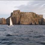
Definitely stop in at Maria Island either Chinamans or Riedle provide shelter from just about any direction and are A grade scenery and good fishing.
I've got Navionics charts updated with recent sonar data for some of the tricky bits for first timers like the Marion narrows through to Denison canal and will see if I can work out how to upload. Note after a few storms there are a few channel markers no longer marking the channel and one in the middle of a sandbar.
An absolute dream for me. Love tassie soooo much. Ive spent years down there at all times of the year and found the most stable beautiful weather in feb march april.
L. I use Google earth a lot when planning, especially kelp can clearly be seen as can the flatness or not of the water in the various bays.
Babel looks good in a nor'westerly.
Because this boat is so small and very rolley with a very elliptical hull form, and because I been on it for 7 years often atrocious weather in open roadsteads, if I'm not crunching rocks the motion doesent interfer with sleep. These Triton 721's have a clipper bow which is a shallow concave and so pitching at anchor can be fierce, especiall as, when anchored, i sleep with my head up against the anchor locker.
So what I'm saying is "any port in a storm" is fine if I'm not dragging and I I've only ever dragged once in 7 years.
I prefer to anchor our in nasty weather then attempt narrow & unfamilar passages like those narrows which eventually lead to Dunalley.
As so many here are offering great advice it's probably opportune to add that I drop the pick from the rocker switch in the cockpit and it's a 35lb Manson Supreme hanging off 250' of PWB 8mm chain. In addition I have two 100' nylon snubbers which if needed can be shackled each near the end of the chain and both those snubbers are sheeted on the p&s heads'l winches.
P.S. If Im boring people with too much info I rather a PM telling me so rather than wear out my welcome on the forum.
Cheers.
I have bellingham & moore and I'll try to find the Victorian book too, probably thru Whitworths because I've never bought anything off the internet.
(a. Because I'm a luddite... b, Because I want to support retailers....and c, Because at times I'm not the brightest light in the street because of war neuroses and its' attendant symptoms. ![]()
Select to expand quotecaptainsinkers said..
This one is another useful guide: jackandjude.com/books/tas-notes/
Definitely stop in at Maria Island either Chinamans or Riedle provide shelter from just about any direction and are A grade scenery and good fishing.
I've got Navionics charts updated with recent sonar data for some of the tricky bits for first timers like the Marion narrows through to Denison canal and will see if I can work out how to upload. Note after a few storms there are a few channel markers no longer marking the channel and one in the middle of a sandbar.
Thanks Cap'n. I'm going to load jack n' jude into my laptop today. My chartplotter has cmap & navionics gold + both of which are ok but I think I'll probably get Nav Platinum plus which has 3d images. In addition, from Boat Books/The Chart Room at Crows Nest I recently bought Memory Map's Quich Charts on cd which has every Aus chart which includes individual charts for the important places such as The Rip into PPB.
In addition, Quich Charts can be individually printed from the computer as desired. Quick Charts are legal raster reproductions of hydrographic charts so even the tiniest of rocks (as Lydia mentioned) are shown as if bieng seen on paper charts. Yes, they are on the laptop but if I want to I can print any of them onto A4. Very useful!
Select to expand quotesouthace said..
I went from Foster inlet on NE tip to wine glass in 12 hours and wine glass to Hobart in 12 hours. Caught the biggest squid I have ever seen in Foster inlet!
ACE, I'll take me days to comprehend the locations of those images. Not knowing the more intimate details of the various locations I'll Google Earth everything to work it all out.
I'm very grateful to you and everyone else too for the guidance and obvious caring.
Going to Tas in any boat, especially this small thing has daunted me often but the last couple of days of imput from so many people has me eager to leave rather than occasionally a little apprehensive. And I'm already indebted to the lot of you. If I forget to acknowledge anyone it's because of brain fade, only !!!