Moving the boat around to western port on Friday morning leaving early what would be the best time through port philip heads
The weather map looks OK waves around 1 meter in Bass straight light windshttps://www.baywind.com.au/ppb/
www.bom.gov.au/marine/wind.shtml?unit=p0&location=vic&tz=AEDT
www.bom.gov.au/vic/forecasts/westernport.shtml
Port Phillip Heads (The Rip) Victoria
Due to the restriction of the tidal range within Port Phillip caused by the relatively narrow entrance the tidal stream near the Heads does not turn at high and low water. The force of the tidal steams depends upon the relative water levels inside and outside Port Phillip. The greatest differences in levels occur at about the time of high and low water in the Entrance when the streams run at their strongest, up to 6 knots under normal conditions and approaching 9 knots in extreme conditions.
Slack water occurs at about 3 hours before and after high water, when the levels inside and outside are the same. The ingoing stream runs from about 3 hours before to about 3 hours after high water and the outgoing stream at other times.
The main body of the ingoing stream from the southward and eastward sets at about 38 degrees directly through the entrance fairway, with drifts of considerable force across and through the reefs, spreading towards Shortland Bluff (Queenscliff) and the southern shore; thence directly through the channels of the Great Sand Bar. The outgoing stream coming directly from the Great Sand Bar channels sets towards Lonsdale Bight, and from there out through the Entrance with great force partly athwart the channel at 200 degrees thence away south eastward along the land towards Cape Schanck.
The water level and hence tidal streams can be significantly affected by barometric pressure and the direction and duration of the winds. West to south west winds cause a rise in sea level outside Port Phillip and a consequent increase both in rate and duration of the ingoing steam will continue till sea levels inside and outside have reached equality, then the increased ingoing stream will cease and the streams become normal. On the winds ceasing, sea level outside falls to normal, causing the outgoing stream to increase both in duration and in rate until sea level in Port Phillip has fallen to normal and the levels outside and inside are again equal.
Select to expand quoteDatawiz said..
HGO2,
pm'd you.
regards,
Allan
Thanks Datawiz I don't take going through the heads lightly
I've done it a few times going to Westerport
I was always directed this way.
1/ Stay outside the shipping channel on Pt. Longsdale site
2/ plan to be in there 1/2 hour before slack water...see tide prediction ...
3/ ask Pt. Long. on chan. 12 /I think /. intention cross channel going to WestPort.
4/after crossing ....heading is Cape Shank
traffic incl. 2 Quenscliff ferries could be annoying
nice little trip,
watch the tide and current in Westernport
Select to expand quoteCharriot said..
I've done it a few times going to Westerport
I was always directed this way.
1/ Stay outside the shipping channel on Pt. Longsdale site
2/ plan to be in there 1/2 hour before slack water...see tide prediction ...
3/ ask Pt. Long. on chan. 12 /I think /. intention cross channel going to WestPort.
4/after crossing ....heading is Cape Shank
traffic incl. 2 Quenscliff ferries could be annoying
nice little trip,
watch the tide and current in Westernport
Cheers Charriot wish you were still down here ![]()
Found this old thread of your Charriot
www.seabreeze.com.au/forums/Sailing/General/Cruising-forum-2/http://www.portofmelbourne.com/port-operations/waves-wind-and-weather
Friday 18/09/15 port philip heads to Yaringa western port
Slack water at Port Philip Heads 6.05 am roughly a 60 nm trip @ around 5.5 to 6 knots motoring hope to arrive before high tide
Western port tides
Day High Low High Low Sunrise Sunset
Fri 18 3:57 AM EST / 2.75 m / 9:44 AM EST / 0.73 m 4:03 PM EST / 2.67 m 9:56 PM EST / 0.50 m 6:16 AM EST 6:11 PM EST
Select to expand quoteYara said..
HG-are you doing this without your mast and sails?
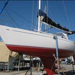
Yes Yarra Ill fit them at Yaringa . Bukh DV20's in good nick . motors good to go. Shes had a hull scrub a couple of weeks ago. Ill be down there tomorrow making her ready . Fuel all oil levels check many things . I did all the filters a few weeks ago. Ill run a temp VHF aerial as mine goes on the mast I have all the safety gear on board.
Id rather have sails as well. I know I'm rolling the dice a little . Weather window looks OK for the next few days
all the best , weather and tide looks ok,
between Point Leo and Phillip Isl. keep in channel also you might get a bit of surfing
and Yaringa channel well here is a picture....

entrance to Yaringa channel from Western port is between starboard shrouds
picture is just passing last pontoon
Select to expand quotecrustysailor said..
AIS HG?
we can watch your progress whilst meant to be working ![]()
Not just yet but on the return journey Id say yes
Your welcome to come Crusty ![]()
I've only been through the heads a few times, and none as the designated skipper.
The first time I was about 17 and busy doing deckwork, and didn't actually realize we actually gone through.
Each time must have been planned well, as they were non eventfull.
The best part about the heads is eating fish and chips watching the pilot boats.
hope it goes/went well.
10am full sail, 6 knots in 10 knots of breeze.......it's not all about lounging around sipping coldies there's work to be done! Don't fall asleep Ho2!


Looking at the tidal flow forecast here:
www.bom.gov.au/australia/tides/#!/vic-the-rip
slack water on friday through the rip is at 04.28 or 11.14 which would provide a sleep in. ![]()
cheers,
steve
Select to expand quotestevesailing said..
Looking at the tidal flow forecast here:
www.bom.gov.au/australia/tides/#!/vic-the-rip
slack water on friday through the rip is at 04.28 or 11.14 which would provide a sleep in. ![]()
cheers,
steve
Well thanks for the link later Steve sailing ![]() what I thought was slack tide was Williams town high tide time equals the rips slack water . Which meant we got a sleep in and had to be there at 6.04 am
what I thought was slack tide was Williams town high tide time equals the rips slack water . Which meant we got a sleep in and had to be there at 6.04 am ![]() and because I got a little stuck on a sand bank
and because I got a little stuck on a sand bank ![]() while rubbing the sleep out of my eyes we were late roughly 6.30 am
while rubbing the sleep out of my eyes we were late roughly 6.30 am
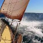
Just before the swell .
Unfortunately Raymarine didn't sponsor our trip so my phone was the dedicated GPS and not a camera so not a lot of photos
The fence picket for the sea gulls to **** on my boat I love them so much ( NOT) ![]()
Ok sorry Seabreeze Fertilize

the rip entrance to port

rip entrance to starboard

I sent Dr Rog a couple of photos while passing Cape Shank the Navionic app read 26 nm from Blairgowie to Cape Shank
Mangofrog Skippered most of the way as I think he was to scared if I took over ![]()
![]()
![]() we had some fun
we had some fun
About to pass Cape Shank navonics reading 26 nm I was talking to Dr Rog 9.16 am when this was taken

At Mangofrogs suggestion we headed over towards the deep water channel near seal rocks as the tide was out bound and the swell can stand up in shallow water with the out bound tide


I think the longest part of the journey is western port to Yaringa Ill be so glad to be able to switch the motor off and sail
I have an old 7 inch android tablet that I just installed navonics on so I used the Iphone as my wifi base we swapped these around some times and topped up their batteries
Philip Island with my VHF aerial in the way the swell depleted from there on into western port just followed the channel markers on the way in
By this time the tide was coming in and added to our speed with the current over 7 knots on the gps
As Mangofrog said if you keep in the channel marks there is deeper water and the waves dont pick up so much if the tides on the way out


Hastings channel turn off we continued into Yaringa and made it around 2pm roughly I remove my seagull perch on the way in
Once tied up I gave Driftwood a quick pressure wash to remove the seagull Fertilized ( is that better Seabreeze ![]() ) A friend of mine who owns a yacht in yaringa was kind enough to give mangofrog and my self a ride back to my car at Blairgowrie Thanks Wolf
) A friend of mine who owns a yacht in yaringa was kind enough to give mangofrog and my self a ride back to my car at Blairgowrie Thanks Wolf ![]()
And Thank Mango Frog ![]()
![]()
Select to expand quoteCharriot said..
Congratulation ...Bass Strait was kind and lovelly, well done.
Cheers Charriot
Ive a list to do now masts. rigging ,anchor winch to install and non skid deck paint hope to have her back in the water by November some time sailable ![]()