Slack water is the perfect time to pass through the heads. Wondering whether you can go through later on a rising tide? Or close to high tide?
Hi bulka,
The short answer to your question is "it depends".
It depends on which direction you want to go through the heads, the prevailing current, winds, swell and sea conditions.
There are many considerations to be taken into account in traversing the heads safely.
For example, traversing (exiting or entering) the heads on an ebb tide with a prevailing southerly wind is generally very inadvisable.
In general, whenever the current is against the wind the conditions can be dangerous.
Peak currents, coinciding with high and low tides, can be up to 8 Knots. Do you have enough engine power to make reliable headway against these levels of current?
Traversing the heads at times other than slack water requires a good understanding of the dynamics and risks involved - it is certainly very inadvisable without significant previous experience of slack water traverses.
Traversing the heads at any time is not to be taken lightly - make sure you fully understand what to expect and the risks involved.
pm me for a very useful document "RBYC Getting through the Rip"
regards,
Allan
Here's a link for Port Philip Heads slack water, tide and current info....
www.bom.gov.au/australia/tides/#!/vic-the-rip
regards,
allan
I agree with Datawiz. Asking the question implies you haven't been through the heads before, so I suggest you be conservative and go through at slack water.
After many ins/outs, I am a bit more confident and flexible, but no matter how "clever" and experienced one becomes, wind against tide (especially during the ebb) at the heads is always something to be wary of.
And just to complicate things, it also depends on whether you're going in/out on the east side around Pt Nepean, or to the west off Pt Lonsdale. Hence the advice - if you have to ask, slack water is your only sensible option.
Google ORCV and check out their "Rip Tours". They take you through on a sizable motor launch with an experienced commentator and you a laminated chart showing all you need to know. Very highly recommended, and fun besides.
It's a bit like crossing a busy road - do it at the right time and you wonder what on erth all the fuss is about. Do it at the worng time and....splammmo - you're on the 7pm news!
Also treat yourself to a copy of "Cruising Vicoria" published by the Cruising Yacht Asociation of Victoria for a excellent coverage (Boat Books have it, or buy direct from CYAV). This book is a must-have for any Victorian/Bass Strait cruisers.
Cheers, Graeme
I think when its high tide at St Kilda its slack water at the heads Am I correct in saying that Data Wiz?
Select to expand quoteHG02 said..
I think when its high tide at St Kilda its slack water at the heads Am I correct in saying that Data Wiz?
I 'think' that's right HG, but I'd prefer to go with the BOM advice at this link..
www.bom.gov.au/australia/tides/#!/vic-the-rip
regards,
allan
I have found the time of slack water to vary quite considerably from the published times, since it is influenced strongly by wind and barometric pressure which can't be predicted at the time the data is published. But if you're going through within about 20 minutes either side you should be ok.
The little Port of Melbourne Tide Tables book, by the way, is a great source of info especially with regard to predicted tidal current velocities at the heads.
Cheers, Graeme
Unless you are very experienced with the rip through the heads stick with going through at slack tide, and when you have a lot of experience it's still advised to stick with the slack tide, I have gone through there at times other than slack (I wasn't the skipper) and it scared the crap out of me, (that was in a large motor boat), I'd hate to be going through on a smallish yacht any time other than slack tide. just my two cents worth.
Anyone mentioned old Nav. rules " 4 finger to West "
My last trip was on T/ S going from St Kilda to Westernport going through Heads at 4 am in winter.
Just follow western channel markers keep heading South until Queenclif had enoug and allow me to cross channel.
Needles to say , it was heavy traffic and thick fog. expirience priceless
Four Fingers West is thoroughly covered in the references cited in previous posts by me and others.
Select to expand quoteDatawiz said..
HG02 said..
I think when its high tide at St Kilda its slack water at the heads Am I correct in saying that Data Wiz?
I 'think' that's right HG, but I'd prefer to go with the BOM advice at this link..
www.bom.gov.au/australia/tides/#!/vic-the-rip
regards,
allan
I used every thing I could find, when I went through Allan ![]()
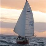
Here is a recent photo of the rip that appeared on the net from Pete James photography taken during a strong northerly and incomming tide.

suggest that you look up tidal streams on bom
not high/low water
lots of info out there
orcv has good info
Select to expand quoteretired said..
Here is a recent photo of the rip that appeared on the net from Pete James photography taken during a strong northerly and incomming tide.
Only two words for that....."Oh S***!!!!" ![]()
I have just booked for the ORCV Rip Tour on 16th Oct. An expensive little jaunt for an hour or so, but I'm sure I will learn a lot in that time.
Select to expand quoteretired said..
Here is a recent photo of the rip that appeared on the net from Pete James photography taken during a strong northerly and incomming tide.
So that's looking from Queenscliff across Ro Point Nepaen?
What jetty is that do you reckon?
This wave is shot is from the track up to the lighthouse at Point Lonsdale, the jetty in the foreground being the Point Lonsdale Jetty.
Although spectacular, it presents no danger itself to transitioning the rip. It is the conditions elsewhere at the heads that is important.
I would strongly recommend anyone considering transitioning the rip to read wongagas' post and follow his suggestions.
The document I have offered was produced by the ORCV who periodically run excellent Port Phillip Heads day tours for people interested in transitioning the rip.
I understand the next tour is Oct 16 2016.
regards to all
allan
That wave looks awesome, but if you were being a good lad and sailing on the Four Fingers West bearing, you'd be something like 100m east of the far edge of the break well clear of the Lonsdale Reef (which is causing the break), and relatively unfussed. Mind you if it was a strong northerly you might find your cocktail shaken not stirred, even on the flood tide.
Cheers, Graeme
If conditions are right, you can stay East or West of the shipping channel. With GPS is easy to follow the edge of the channel
and from my expirience sea state on both sides are identical. I used to cross channel going overnight to Port Arlington,
but many yachts and boats simply avoiding to cross shipping channel twice.
been through the heads half a dozen times always have been around slack water and reasonable weather have been a little late and seen the whirlpools running but nothing like that wave ,would be awesome.Though don't like to think of the weather you would see in the strait with a wave action like that
In last 35 years more boats been lost entering or leaving Westernport than PPB.
Many years ago leaving Westerport on 47" yacht " Yantara" we expirience 8 m waves,
miles before Cape Shank. Passing Cape Shank, Bass Strait had no waves just mild swell.
Actually waves on pic. are not rare in Port Phillip , entering Mordialoc creek,
gusting 35+ you see many of those.
Select to expand quoteCharriot said..
In last 35 years more boats been lost entering or leaving Westernport than PPB.
Many years ago leaving Westerport on 47" yacht " Yantara" we expirience 8 m waves,
miles before Cape Shank. Passing Cape Shank, Bass Strait had no waves just mild swell.
Actually waves on pic. are not rare in Port Phillip , entering Mordialoc creek,
gusting 35+ you see many of those.
There's a couple of spots where the waves don't build as much in western port its sightly deeper in a couple of spots. But just the same they roll in
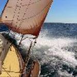
Just went through the heads 30kts Nw, fairly straightforward going through after 13 day trip from Hammo to Melbourne .sorry photos upside down


Select to expand quotespiggie said..
Just went through the heads 30kts Nw, fairly straightforward going through after 13 day trip from Hammo to Melbourne .sorry photos upside down


![]()