So many boaters are contributing to the Zulu Waterways Cruising Guide in Australia now. The amount of information is growing by hundreds of icons a week. Despite this, there are a few areas that need filling in through some local experts.
Port Phillip Bay- Are there boaters in Victoria who have a good knowledge of this area who can add in some anchorages.
www.zuluwaterways.com/map/-37.849907601371676/144.93882102164991
Darwin- This area needs someone to add in the cyclone anchorages and other local info.
www.zuluwaterways.com/map/-12.43047425290456/130.83098828770414
Perth- Could use some anchorages adding to it.
www.zuluwaterways.com/map/-32.029196183426144/115.75746948139738
Does anyone have data from these regions?
Hi Toby on H28 Meridee put me onto site. Presently in Coffs Harbour exploring the app.
Yeah, cool. We had a great time at the Airlie music fest last weekend with Kay and Toby.
Which way are you heading? How do you like ZW?
Just added a nice anchorage in Port Phillip in the shade of the cliffs running east from Matha Point.
I saw that. I was wondering where all the anchorages in Port Phillip were as no one has added any in yet.
What is that beautiful boat in your Zulu profile pic?
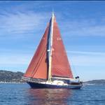
The boat in the pic is warana 11 built in 1956 in Brighton, Vic. We bought her in 2014. A motorsailer of 30 ft built of Tallowood.
Hi Toby on H28 Meridee put me onto site. Presently in Coffs Harbour exploring the a
Yeah, cool. We had a great timee image at the Airlie music fest last weekend with Kay and Toby.
Which way are you heading? How do you like ZW?
VIP tent with kids! What were you thinking?
I am heading South. Soloing down to Sydney. Southport2 Coffs overnight Tuesday. Coffs 2 Port Stephens last night. Just having a look at ZW for Port Stephens now. ETA 7.00 am. I think it is a pretty good idea. I like the Google view of a location. I had a guy in Fiji put me onto Ovitalmap which is really good to download detail of pretty remote locations. Of course you have to do that while you still have WiFi.
@Guitz I gave Killers of Eden a good blast when we departed Eden for Fiji
Ha the Killers of Eden! That would have set the tone for a great start to the journey as Mt Imlay dipped below the horizon!
Used the Zulu Waterways guide to good effect in Sydney and will make comment in the guide on
1/ Great service at D'Albora marina Rushcutters Bay for a courtesy 4 hr pen while waiting for my son to arrive from airport. The CYC and this marina are convenient pick up/ drop off points by rail link to airport.
2/ Zulu suggested must stay anchorage Farm Cove for iconic nighttime view. (At cost of ghetto blaster party boats Sunday afternoon).
.......ghetto blaster party boats! My pet hate when staying at Docklands in Melb. I call it pollution of the waterways!
Used the Zulu Waterways guide to good effect in Sydney and will make comment in the guide on
1/ Great service at D'Albora marina Rushcutters Bay for a courtesy 4 hr pen while waiting for my son to arrive from airport. The CYC and this marina are convenient pick up/ drop off points by rail link to airport.
2/ Zulu suggested must stay anchorage Farm Cove for iconic nighttime view. (At cost of ghetto blaster party boats Sunday afternoon).
Great. Glad it was helpful. Having people comment and edit information they have visited/know about is so important. It's the whole idea really. Putting in that effort to do so makes a big difference to the whole Zulu community, so thanks for that.
We finally worked out how you are
connected to Toby and Kay. Sounds like you've been on quite an adventure recently. Where to next?
Having current and up to date "local knowledge" information is invaluable. I will probably add some Port Philips info and Gippsland lakes stuff. Heading for Lakes Entrance at present.
i will be sailing across to Devonport for the laser nationals in January, then preparing for a rerun of the Fiji masters trip, will stay a bit longer and go to some of the outer Islands in Fiji next time.
There were some cool changes to Zulu Waterways this week. As a map option are now world Navionics charts, free to use. The icons have also had a facelift. What do you think?
That chart is WAY OUT OF DATE CAUTION !!!!!!
The leads will bring you in from the NE [or there a'bouts] it consists of a white laser light which will go to red if you are off the leads.
To get on the lead from the south you need to go well north of Port Macquarie before heading inshore.
You will pass to the east of the isolated 2m patch.
The leads are located near the end of the southern training wall.
Great to know. So many people use navionics and it's not going to always be up to date and that's exactly how Zulu can help dispel bad info. I see you commented on the navigation marker there to reflect your information. Keep it coming.
We are in discussions with a Zulu user who is part of marine rescue. He has sent a message up to the powers that be to organise the marine rescue officers in each location to update Zulu with the latest info when it changes. This will help, along with the sailors who contribute and update the information themselves, to provide current and well rounded information.
Unfortunately that doesn't work with MR all of the time as they will take the Official view, hence the miss information we had at the Camden Haven Inlet and the Crowdy Bay Harbour which I have just corrected.
There were some cool changes to Zulu Waterways this week. As a map option are now world Navionics charts, free to use. The icons have also had a facelift. What do you think?
Nice additions, keep up the good work!
There were some cool changes to Zulu Waterways this week. As a map option are now world Navionics charts, free to use. The icons have also had a facelift. What do you think?
Nice additions, keep up the good work!
I have just discovered Zulu.
I want to know how to use it.
I think there are FAQ but where?
General faqs can be found on the site/app
www.zuluwaterways.com/faq
Here is a video explaining how to add a new icon