Weather | Buy&Sell | Forums |  |
Weather | Buy & Sell | Gallery | Forums | |
All
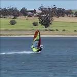
Three years ago I wrote a program called Sailplay. It's a program that converts GPS log data into a google moving map movie (MPEG) file. Here are two movies I produced for a mate last summer from his GPS log data:
Sounds good to me.
Can you have multiple GPS files running at the same time, so that you can show multiple people on the same map? This would be good so that you can watch it like a race.
That looks very clever. Would you plan to sell it or make the application available for free?
Looks awesome, I saw something similar, but on a static map, not nearly as good. I have some programming background, would be ready to use it from the command line anytime, but should not be too difficult to wrap your commands in a graphical UI. Or in the beginning you could get the user to edit a config or batch file to pass the parameters to the application. Great work.
I like the colour coded speed.
I'd be willing to pay a few bucks for a user friendly bug free version. I think this type of thing will eventually come in on most GPS software but if you get in first you might make an early name for yourself that sticks in peoples minds and promotes a bit of brand loyalty.
FormulaNova: Yes, definately :)
Mobydisc: It will be released under the the Perl foundation artistic
licence 2.0 (ie: freeware). Note: Sailplay is written in 'C' not Perl though.
powersloshin: The first step is just getting it working under windows.
I've never done this before, so a bit of a learning curve. By that
stage, people can start using it. I could semi-automate the process with
desktop shortcut icons that run commands (ie: user renames a GPS log
file, "in.txt", then double clicks a shortcut icon, movie file then
appears etc). If it gains momentium, I could look at making it a proper
Windows app. However, I'm not a Windows developer, and I'm not going to
splash out on a developer's licence, which I think costs a few grand.
Cluffy: Thanks :)
Sailhack: There is one in Nick's movies, but it's scaled to be the same
size as a real windsurfer, and the view is too far away to see it (I did
that for a reason in Nick's movies, but long story). Note: In my
program, the sail racks back when you go fast for effect.

J
I think that its pretty cool.
Do you know what gps software the yachties use to track their races? Saw this in the Olympics and looked quite good. being able to pan in and around like that is definitely awesome. Great for races and making sure everyone make it around the mark.
Interesting if this could be written into a smartphone app? Track and render your trip, or log your trip live via the cell connection onto a server for a race so it can be viewed from shore on a screen connected to a computer... good for spectators.
Plenty of people are using Linux OS's, just a lot more (hell of a lot more) are running Windows.
Did a bit of C and VB coding at uni so might be able to help a little bit, haven't got much spare time, currently working in infrastructure doing some application packaging and other stuff so getting non standard apps working in win7 is fairly standard part of my day.
Happy to lend a hand.
Cheers
Graeme
jermaldan: I'm guessing they would use the NMEA0183 standard (pronounced "Enemy 183"), which is a defacto standard for weather stations and GPS loggers (the GT-31 GPS logger records NMEA0183. Here is the link to the protocol. www.tronico.fi/OH6NT/docs/NMEA0183.pdf. Yes, portable devices is the way of the world now. Unfortunately Sailplay doesn't track live, but it wouldn't be too hard to recode for it to receive live NMEA0183 streams via wireless etc. In Unix-land (and windows has copied this too), everything is either a file or a process, and a wireless connection is treated in unixland as a file too. So yeah, piece of piss to modify it to display realtime feeds from remote GPS loggers as you described.
GWilko: Times have changed too. The era has homebrew software is gone. Big companies have have hijacked GPL, which is good and bad..![]()
To all that have replied, thank you for your positive feedback, but the numbers aren't enough. This is niche software, and it looks like it won't get any interest if I went ahead. However, I'll make Unix/Linux distribution publicly available to all. Watch this space. For Mac OS X users, this should work (ie: downloading a GCC/binutils toolchain and compiling/making/installing distribution) on your equipment, as OS X is really just a Linux/X-Windows system. If you are keen, and you need a hand getting it going, then I'm more than happy to help guide you ![]()
Hi,
I have both an Mac and an Android phone. I'm thinking about getting an Android tablet later on. If you could get an app like this going on either device that would be unreal.
I'm keen to be a tester for Mac if you need one.
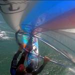
A question about your utube vids. How where they recorded?
Don't underestimate response from replies so far. Post this again on the GPS forum. They are the ones most likely to be interested, and rename it "Turn your GPS track into a movie". Frankly I have seen your post a few times and never bothered to look at it because the title is too obscure.
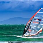
I think you are very clever and it's a great idea. I always like to look at my GPS track after a session and I'd like to trace my track to work out where a certain event occurred but sometimes the spaghetti lines get so crossed over I can't.
Love the colour coding for speed! That is really useful.
Perhaps you can talk to KA72 (Dylan) and combine your efforts? Just as after dowloading data to KA 72 you can view your track on google earth, perhaps you could view it on sailplay? That might take out any tricky steps the sailor has to do him/herself.
Don't give up. It's a great idea.
I am keen to give it a go... I am a Mac user so would need some help to get it up and running.
Great visuals.
Fez
Sailplay revision 9 is now publicly available. This is a Unix version and will only work on operating systems like Linux, OpenBSD and (and with some poking) Mac OS X. Here is the link below:
www.fileden.com/files/2013/3/29/3431045/sailplay-9.0.0.tar.bz2
I'll investigate a Windows port when time permits. Watch this space.
J
I'm getting 'file not found' when I click on the link. Anyone been able to download it?
This seems similar to the GPS Action Replay free software which also has a paid version more up to date. It allows you to see several GPX 0r NMEA tracks simultaneously and you can superimpose it on a google earth or map (though I never did that). We used to use it to follow our Formula Racing a few years ago but it died out. The free version is no longer supported but you can still download it. I can't get it to work on my laptop but is fine on my XP desktop. I use it now to see where I went fastest during a session, it will display the speed, VMG, wind direction & gives the statistics for the session. I am saying all this in case you are wasting your time, your version looks cool.
FormulaNova: Okay. That file den site doesn't look like it's any good (it's been a long time since I have released something. It used to be FTP repositories). I'm just recovering my sourceforge account. I'll try uploading it on that and repost a link that works. Thanks for letting me know (failing that, I can email you the file).
Bruce: Thanks for info. What you have just said has set my mind at rest. I won't waste my time since there is Windows stuff already out there that does the same job (unless some budding software developer wants to do it as an exercise ??).
AUS1975: Okay, thanks.
I'll repost a sourceforge download link (if it works) and leave it at that. Watch this space.
J
Okay FormulaNova, try the link below.
sourceforge.net/projects/sailplay/files/latest/download
J
Could you suggest a similar software to yours that runs on Windows, since you decided not to develop the Windows version yourself? Btw the software looks great and I would really need something like that.
Thanks!
how would it go for a 3d overlay onto google?
theres a whole bunch of wing suit fliers i know that would be a good market for this stuff if it was made really simple to use. we need it for performance checking our jumps and for a new competition thats developing in distance flying.
That pigeon racing tracking device is pretty cool gives you a perspective on where & how we could do it in windsurfing.