I was really excited today when I found an old box of slides which I thought had been lost. They were taken on what I think was my third trip to Sandy Point in 1963. We had visited a couple of times before whist camping at Wilsons Prom with friends, the McCubbins, but this summer we camped there in our caravan for a few weeks, right on the foreshore opposite where the general store now is! I have been going back there ever since!
In 1963 I was 12 years old and was the very proud skipper of a little red Sabot dinghy called the 'Flying L'. (No idea why) This was the first time I sailed at Shallow Inlet, and on the 'Boat Hole'.
Here it is with my sister Talana as crew:

It was quite an adventure to get from the township of Sandy Point to the Inlet. There was just a two wheel track through the sand dunes and it was not uncommon to get bogged on one or more of them on the trip. Lots of fun for mum and the kids digging and pushing.![]() I don't think this time we were bogged. Dad just stopped to take a photo.
I don't think this time we were bogged. Dad just stopped to take a photo. ![]()

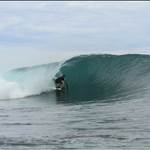
Here is what the Inlet looked like in 1963. You can see clearly why we call this the 'Boat Hole. ![]() . I was really surprised that this picture clearly shows the remains of the old jetty piles! They were a legacy from when the boat hole was the main channel out into the ocean!
. I was really surprised that this picture clearly shows the remains of the old jetty piles! They were a legacy from when the boat hole was the main channel out into the ocean!

I still remember vividly the 'great adventure expedition of '63'. The family walked down the the entrance. It seemed like a huge trek at the time, but the entrance was only about 1km from the car park back then! I don't actually remember what the 'speed course' looked like in those days but it must have been much shorter. At least there was hardly any vegetation or sand dunes on the spit back then!![]()
Dad took this photo of me setting out:

Here is the family having a rest on the way. Note there are no sand dunes whatsoever!

And here we are lined up for the brag photo when we made it!:

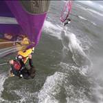
Here is the big sand dune next to the car parking area. Not a sign of Marram grass on it. Note the windsurfer on the car. ![]() Hoyle eat your heart out! I had one in '63 and didn't even realize it. Sadly, I hadn't figured out how to sail it yet. I just floated around on it with a double ended paddle, often standing up. Hey, I might have been the inventor of SUP!
Hoyle eat your heart out! I had one in '63 and didn't even realize it. Sadly, I hadn't figured out how to sail it yet. I just floated around on it with a double ended paddle, often standing up. Hey, I might have been the inventor of SUP!![]()

It looks a bit different now doesn't it? Oh well, I guess I do too! ![]()
Wow!...they are great pics Daff....I wonder if it would be possible to go back and try to get the shots from exactly the same location...that'd give us a slice of 50 years- then to now
Wow that is amazing, it just shows what a rapidly changing landscape it is.
Probably about the same time, maybe a year or two later I also invented Windsurfing. I used to stand on my plywood paddle board my grandfather made me and hold one of those big styrofoam surfboards ( I guess the precursor to the boogie board) up in the air and get blown offshore at Blargowrie. My mate would sit behind me and steer with the paddle. It used to get up a bit of pace in 20 knots. Then we would paddle back in.
Maybe it was more of a yacht than a windsurfer and I was the mast.
Fun times!!!
Martin. Ours was also a hollow plywood paddle board, made by my carpenter uncle. Not much different from a Windsurfer One Design really, just a bit smaller!
Bender; Well, it wasn't from my mothers side anyhow! ![]()
Great idea about the photos Mick. I will have a go at it.
Larko, I think I may have put on a few pounds as well! ![]()
Swagger, you are so right!![]()
Wow thanks daffy
Two things
1 how good is that xk falcon in green. I had a xm ute in same colour - cried the day I sold it
2 the slides retain that glorious colour - I love all those luminescent film stocks - check the colour of the sabot in slide 2 or the water in slide 1 ![]()
this thread made me a little teary.
also reminded me of when i invented towel boarding.
it was 30 knots, my parents wouldn't drive me to the beach so i got my skateboard and my beach towel and off i went. ![]()
noice one quikky, isn't it interesting how both fords and sabots have evolved at about the same rate in the last 50 years ![]()
Nice post sailquik, great pics.
I too started off in a little red Sabot, I called mine "Saboteur", as I suspect a lot of other kids did.
This is Brilliant Andrew - many thanks.
Any chance you could draw us a map to give your rough idea/memory of where the entrance was and where the dunes extended to? Even over the last decade and a bit it has changed a lot from my perspective - this may be due to a change in mean wind direction during the drought period, when we had generally fewer fronts/SW'ers.
Today looks very different in this old map < > (and be fascimating to get some old aerial photography... www.ga.gov.au/flight-diagrams/FlightDiagram.flightDiagrams?sj5510)
I'm quite fascinated by this stuff, with both my personal (love Sandy) and professional (climate guy) hats on.
> (and be fascimating to get some old aerial photography... www.ga.gov.au/flight-diagrams/FlightDiagram.flightDiagrams?sj5510)