|
Help & Support
 Membership
- Forgot my login name / my email!
- Forgot my login name!
- Forgot my login name, password and changed my email!
the Contact page
and an email will be sent to you with details of your login name, and the opportunity to change your login.
- How do I change my email?
- How do I change my login name?
If you've not posted much, then write to us via the feedback page with at least three new names you'd prefer and we'll help you out.
- How do I change my password?
- How to prevent email going to the "bulkmail" folder
We recommend that you add seabreeze.com.au to your 'Approved Sender' list, within your email reader.
Hotmail Users:
If you do not receive the confirmation message within a few minutes of signing up, please check your Junk E-mail folder just in case the confirmation email got delivered there instead of your inbox. If so, select the confirmation message and click Not Junk, which will allow future messages to get through.
We strongly recommend that you do the following to avoid accidentally filtering our future messages:
1. Click Mail, then Options (next to the Help link)
2. Click Junk E-Mail Protection
3. Click Safe List
4. Enter this domain: seabreeze.com.au
5. Click Add
--> Do not forget to click the link in the confirmation message. Otherwise, you will not receive any of our future emails.
Yahoo Users:
If you do not receive the confirmation message within a few minutes of signing up, please check your Bulk Mail folder just in case the confirmation email got delivered there instead of your inbox. If so, select the confirmation message and click Not Spam, which will allow future messages to get through.
--> Do not forget to click the link in the confirmation message. Otherwise, you will not receive any of our future emails.
Gmail Users:
If you do not receive the confirmation message within a few minutes of signing up, please check your Spam folder just in case the confirmation email got delivered there instead of your inbox. If so, select the confirmation message and click Not Spam, which will allow future messages to get through.
--> Do not forget to click the link in the confirmation message. Otherwise, you will not receive any of our future emails.
Outlook 2003 Users:
1. Select Actions from the top menu bar, then select Junk E-mail followed by Junk E-mail Options.
2. Select Safe Senders, then Add.
3. Type seabreeze.com.au and click OK.
4. Type sender's 'from' address and click OK.
5. Click OK.
--> Do not forget to click the link in the confirmation message. Otherwise, you will not receive any of our future emails.
AOL Users:
If you do not receive the confirmation message within a few minutes of
signing up, please check your spam folder just in case the confirmation
email got delivered there instead of your inbox. If so, select the
confirmation message and click This is Not Spam, which will allow
future messages to get through.
We strongly recommend that you do the following to avoid accidentally filtering our future messages:
1. Click Mail in the toolbar at the top of your AOL window
2. Select Block Unwanted Mail
3. Click Custom Sender List
4. Select Allow only the senders and domains listed below
5. Enter seabreeze.com.au
6. Click Save
--> Do not forget to click the link in the confirmation message. Otherwise, you will not receive any of our future emails.
Everyone else:
If you do not receive the confirmation message within a few minutes of signing up, please check your Spam or Bulk E-Mail folder just in case the confirmation email got delivered there instead of your inbox. If so, select the confirmation message and mark it Not Spam, which should allow future messages to get through.
--> Do not forget to click the link in the confirmation message. Otherwise, you will not receive any of our future emails.
- I didn't get my re-activation / password change email!
Normally, it's just delayed. We've made every effort possible to ensure our emails get through spam filters, and we've confirmed that 90% get through.
The remainder usually fall into these categories:
- "held up" by other computers in the chain of delivery.
- Ended up in your Junk Email folder of your email system.
- You're using a service such as Spam Arrest, which requires manual acknowledgement by us.
If it's been over an hour, and it's still not arrived, send an email to us via
the
Contact page
and a real live human will sort it out for you.
- Where did my Private Messages go?
If you've received a notification of an email, make sure you're logged in using the member name contained in the email.
 Weather
- Can I get wind history for location xyz...
- Can I have the raw wind data for d/m/yyyy?
- Can I put your weather on my website?
- How do "My Graphs", custom weather layout work?
It's easy!
Selecting graphs for your favourites page
First step is to visit your normal weather page (e.g. Graphs / WA / Metro) and pick off the graphs you want on your favourites. You do this by clicking on the favourite

icon located at the top left of each graph.
When you select the icon, it turns sold

to shows that you've select the graph in your favourites.
Continue picking the graphs you want. If necessary, visit any other graph pages to add other graphs of interest.
When finished, view your favourites, page by selecting the
Graphs / My Graphs
menu.
Once there, you should find the weather graphs you selected.
You can easily remove graphs no longer required by deselecting the favourites icon at the top left of each graphic.
You can also shuffle the order, by using the Move Up/Down icons ..

,

.
You don't even need to register or login to use the favourites.
Trouble shooting:
If you find it's not remembering your settings, check the cookie settings in your browser! No cookies = no favourites.. sorry.
- How do you do your forecasts?
The weather often chooses it's own path of action, and we're in a constant state of trying to keep up with it and create forecasts that are accurate and reliable. To do it, we use over 6 different sources of data, apply our own proprietory local area algorithms, a human touch, and the results are the graphs you see. We built the systems years ago, but the code was lost in an unfortunate office accident late one evening during a christmas party windup involving an employee, a gold fish bowl and a set of golf clubs. The code was lost and the employee now has a limp. :-)
- How does the weather work?
|
|
Wind Glorious Wind...
If you're into a sport that is affected by the wind, it pays to understand how wind works.
Wind...
Wind is the movement of air molecules from one location to another. The perfect demonstration of wind is
with a fully inflated car tyre. If you open the valve on the car tyre, air rushes out. Why? Because
there is more air pressure in the tyre than there is in the atmosphere, and the atmosphere is always seeking to equalise pressure.
Higher pressure pockets of air (i.e. inside the car tyre) move to equalise lower pressure areas. So what causes these
low pressure areas? Well, in the case of a seabreeze, it's caused by heat...
Seabreezes...
Cold sinks, heat rises. It's the concept that makes hot air balloons work, and why your vegies are at the bottom of the
fridge. During a summer day, the land is heated by the sun, and this heat is absorbed by the surrounding air.
Once this air meets a particular temperature, it begins to rise quite rapidly. As a result, a low pressure area is
created at ground level. The sea doesn't heat up as quickly as the land, so the air temperature over the water is much
less. As a result, this air is free to move sideways to occupy our new low pressure area. The
result is a light to gale force wind which rushes in from the sea to fill the lower pressure area left by the hot air rising from
the land. Seabreezes usually happen in spring and summer, when the difference in temperature between land and
sea is greatest.
Seabreezes are the most amazing phenonenom. For many years I never really paid much attention to the wind.
One day, we arrived (late) at the local river to do some water skiing. It was around 1pm, the water was glassy - perfect
conditions. Then, my mate Mick says "Here comes the seabreeze...". Looking across the river we could see
an approaching line of rough water. And then it hit us full on - the full glory of a 25 knot seabreeze.
What's even more amazing is that the wind can be travelling faster than the front of the seabreeze. It can be progressing
inland at 25 km/h, but the actual wind can be blowing at 35 km/h! Sometimes the seabreeze can reach 100+ kilometers
inland, and other days it teases you by staying just offshore, coming in, and then going out again.
So to get a seabreeze, it needs to be hot inland. But too hot and you won't get one at all. To explain why
this is the case, we need to understand high's and low's and the squiqqly charts they show on the telly called 'Synoptic Charts'.
Synoptic Charts...
You need to understand these if you want to have your own guess at what the wind may do. It also assists to understand
what the weather man is talking about. Sometimes our local TV weather reports simply say '.. and an afternoon seabreeze'.
About as useful as an ashtray on a motorbike.
So check this out:
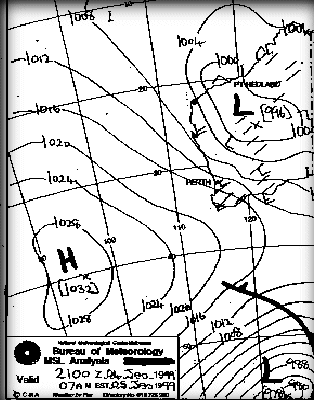
From the title, it says MSL Analysis. This means it is a Mean (average) Sea Level Analysis. A slice of the
atmosphere at sea level. The way the atmosphere changes at different levels is also extremely interesting, but beyond
what we talking about here. The numbers indicate the air pressure, called the Barometric pressure.
Barometric pressure is measured in hectopascals. Bigger numbers represent greater air pressure.
The chart is generated by acquiring a huge number of readings from ships, sea based automatic weather buoys and land based weather
stations.
These data points are then processed using complex mathamatics to 'best guess' or 'interpolate' values for
areas where no reading was available. The meteorologist then sharpens his best HB pencil and draws lines connecting areas
of equal pressure (called isobars, or contours), draws a H in the middle of any Highs, and an L in the middle of any Lows.
They also draw another chart called a prognosis which is what they estimate to be where the weather will go. It's always
valuable to compare the analysis with the prognosis to get an idea of where, and at what speed the weather is travelling.
So high pressure areas rush to fill low pressure areas huh? If that was the case, then you would expect the wind to
travel like this:

Bzzzzzzzt. Wrong! These are complex systems, and there's other forces at work here, plus lets not forget
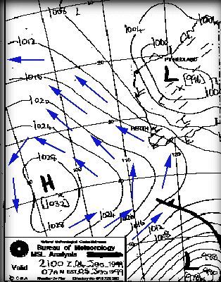
that the world is 3D and this is only a horizontal slice. The world is spinning, which creates an extra sideways force. To simplify, visualise the surface of a spinning tennis ball. There is a "wind" blowing across the surface of the tennis ball due to its rotation. As a result, wind actually travels pretty much in the direction
of the isobar lines. And in the southern hemisphere they travel anti-clockwise around high's and clockwise around lows.
And the whole weather pattern moves (generally) in a west to east (left to right) direction. So the
wind actually blows around the high cell like this:
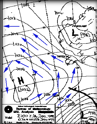
This all adds up to help determine the kind of local wind effects such as seabreezes along the coast in the afternoon.
This synoptic chart is a joy to a wind fanatic living on the coast of Western Australia because this pattern means wind - and lots
of it - these cool winds also keep the maximum temperature down. In fact, the forecast for this pattern was:
TODAY'S MAX: 23 C (74 F)
Strong Wind Warning current.
S/SE winds 20/30kn in the morning, tending S/SW and strengthening
to 25/32kn in the afternoon.
The S/SE winds in the morning reflect the anti-clockwise direction of wind around the high, untill the afternoon when the thermal
induced seabreeze kicks in and changes to an onshore S/SW.
But that low cell sitting up in the north is what can ruin it all. These low pressure systems descend in a southerly
fashion and bring with them hot and humid conditions. They are called troughs and generally spoil any chance of a seabreeze,
as indicated with this chart and forecast:
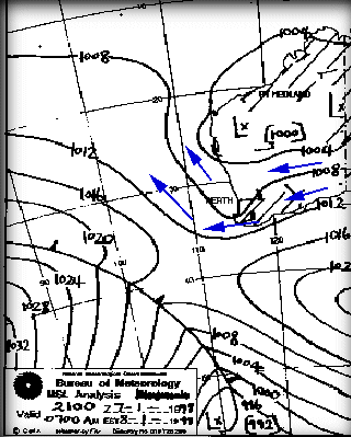
FORECAST:
TODAY'S MAX: 35 C (95 F)
E/NE winds 15/20kn, easing to 10/15kn by late morning. Winds shifting
NW/SW 10/15kn during the afternoon.
The capital city of Perth is going to be blasted with E/NE winds in the morning, brought in nice and fresh from the deserts,
and these winds are toasty - a maximum of 35 degrees C, and only a mild, if any, seabreeze. But wait - that's
a cold front approaching from the south west, and there's a good chance that this will push the trough inland and bring back the
seabreezes.
Generally speaking the thing to look for when looking for strong seabreezes is a new high cell
aproaching (following a previous high cell), or a tough moving inland and being replaced by a new high (extra windy!).
Cold Fronts...
Well, unlike seabreezes, cold fronts are active mainly during winter and come at any time of day or night. Cold
fronts do pass through during the other months, but their effect is usually not noticed by most. Like seabreezes, they come
in all sorts of flavours from simply making the sky cloudy to full on roof removing gale force winds. Cold
fronts, as the name suggests, is a line of cold air travelling along, generally west to east. As this cold air meets warmer
air, the warm air rises, and you guessed it, causes the cold air to rush in and fill the space. Thus, the
actual 'front' of the front, called the 'squall line' is generally where most of the wind is.
Cold fronts are great when they come through, producing great local names, such as the 'Norwester'. Because the winds travel
clockwise around a low pressure system, the first taste you get is Northerly, but more often than not North Westerly. As
the cold front passes through these winds rotate around the compass, going from NW to W to SW, and maybe S. The
S part can get quite chilly because it's dredging all the cool air from the antarctic region.
Not cold by UK standards, but enough to make your face numb. North Westerlies on the otherhand can be quite warm,
relative to the usual winter temperatures. The time it takes for the NW to SW transition depends on the speed at which the
front is travelling. Usually around a day, sometimes two.
Time to introduce another term - the pressure gradient. In the synoptic charts displayed above, the isobars have been
relatively spaced out, because the difference in air pressure is quite small over a large area. When we get a large
change in air pressure over a small
area - rig up your small sails/kites - it's gonna blow.
Checkout this chart - one of the windiest days in the winter of '98. Blue arrows indicate wind direction. See how close
the isobars are together. Also, remember that the entire frontal pattern moves from left to right (west to east),
but the winds blow in the direction of the arrows. I hope you can grasp the concept!
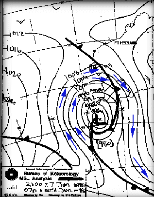
FORECAST
TODAY'S MAX: 19 C (67 F)
Gale warning current.
W/NW winds 30/40kn this morning with possible squalls to 60kn in
thunderstorms. Winds tending W/SW 20/30kn by early afternoon and
easing to 15/20kn this evening.
One of the best things about a cold front is that extra commodity - waves. As any sailor knows, wind generates
waves. The more wind, the more waves. If you've experienced a strong cold front, you know that they can get extremely
windy, as a consequence the waves can get quite large.
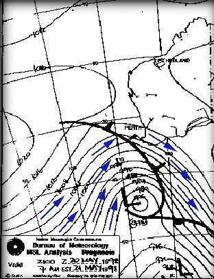
Here's another less extreme (for Perth, anyways) cold front. In Perth it blew around 20-30 knots, whilst the south coast
received 25-35 knots.

|
|
- How good are the tide forecasts?
The actual water level height and speed of change may vary under certain weather conditions, such as unusually high or low barometric pressure or by prolonged strong winds.
Low-pressure systems usually raise sea levels and high-pressure systems tend to lower them. It takes some time for the water level to adjust to the pressure change, and that pressure change needs to occur over a significant area.
As you can imagine, a strong wind will raise the water level in the direction it is blowing, and may cause the "high tide" to be higher than predicted.
- How to read the Wind graphs
|
How
to read the Wind graphs
-
Did you know that the arrow colours are reversible?
This site was originally built for Windsurfers & Kitesurfers - where strong wind is a good
thing, so
green
=strong wind.
If you boat, fish or surf, then light wind is a good thing, so ..
red
=strong wind.
To reverse the colours in the graphs,
click here
-
How to work out the Wind Speed
The most recent live reading is at the right hand end of the graph, and up to 12 hours history
extends towards the left - check out the time label at the bottom of each graph.
Arrows indicate the strength by their Height on the graph and the colour of the arrow:
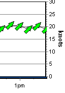 Green Arrows indicate Strong wind, which is 18+ knots, 30+ Km/H, Force 5 or
more.
This graph shows an 18 to 20 knot southwester around 1pm
|
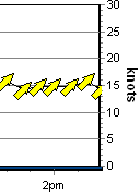 Yellow Arrows indicate Moderate wind, which is 12-18 knots, 20-29 Km/H,
Force 4.
This graphs shows a 14 to 16 knot southwester around 2pm
|
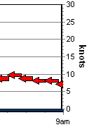 Red Arrows indicate Light/No wind, which is 0-12 knots, 0-19 Km/H, Force 3 or
less.
A 7 to 9 knot easterly around 8-9am
|
Table of wind speeds
|
Symbol
|
Term
|
Knots
|
km/h
|
Beaufort
|

|
Light
|
0 to 10 knots
|
0-19 km/h
|
Force 3 or less
|

|
Moderate
|
11 to 16 knots
|
20-29 km/h
|
Force 4
|

|
Fresh
|
17+ knots
|
30+ km/h
|
Force 5 and above
|
-
The Middle of the arrow is where you
should read the wind speed from the scale at the sides. Picture the arrow as
being like a compass needle, where it rotates around a central point of
balance.
-
The Grey arrows
indicate the maximum gust during the 10 minute period.
-
Time of day is displayed along the
bottom of the graph.
-
The site was initially designed for Windsurfers,
so the colours use a Traffic Light type colouring, which may be the opposite of
your needs .. especially if you surf! You can reverse the colours in the graphs
by
clicking here
-
For most locations, the wind strength and
direction is the result of a 10 minute average
-
How To Read The Wind Direction
 The
arrows indicate the direction the wind is going based on North being at
the top of the screen and West being at the left.
This concept confuses some people first off, because they are expecting the arrows to
work like a weather vane and point towards the arriving wind.
It can also be confusing if you're looking at your computer monitor in a Southerly direction, as all the
directions will be reversed.
We had to choose whether the arrows were indicating where wind went, or where it came from.
We figured that most things in life, such as street signs (e.g. one way signs), swell direction arrows and traffic cops all point in the direction
that something is going.
Pointing where the wind is going also makes good sense when the arrows are overlaid over a map
(..see demo)
Take a "Northerly" wind, for example. "North" is at the top of the screen (as maps generally have their
northmost point at the top), and a "Northerly" is a wind that travels from the North to the South, so it is
drawn as an arrow that points down - that is, pointing from North to
South.
Easterly Example: An easterly wind heads from the east (right side of
the screen) towards the west (left side of the screen), so the arrow is drawn
pointing to the left.
-
Sunrise & Sunset
The grey shaded area of the graphs indicate night time. The graphs are live 24 hours are day and always
display the most recent 8 hours of live wind data. You can also view yesterdays full 24 hour history by clicking
the "Yesterday" link located in the left hand menu.
The graphs below show the progress of an awesome West Australian seabreeze, and displays from Midnight to Midday
As illustrated by the grey gradient, Sunrise was at 5:32am
 In the graph above, you can see the seabreeze arriving at 10:30 am where it shifts from a SE to a SSW.
The graph below is 8pm later the same day, and shows the previous 12 hours to 8am.
The grey gradient at the left indicates night is approaching (sunset was 7:32pm)
 This particular day was an amazingly consistent 20 knot southwester which continued right through past midnight...interesting
change of direction from SSW to S once the sun went down...

-
All times are aligned!
|
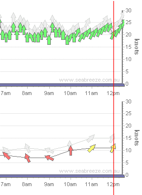
In the example graphs below, the wind graph at the top has readings every 10 minutes, whilst the graph underneath
every hour.
The Time axis of all the graphs on the same page always align vertically.
We've drawn the red line over the graphs to show how the times line up.
This example shows two graphs at 12:30 pm. As the lower graph only reports on the hour, there is a gap to show the time since
the last report. The upper graph has data every 10 minutes.
Stations that report hourly will have a gap at the right hand side due to the lower reporting period,
and this makes it easy to verify the latest readings.
|
The red line shows how all the graphs times align.
|
- How to read wind forecasts
Wind Glorious Wind...
If you're into a sport that is powered by the wind, or want to avoid windy days then it pays to understand how wind works.
Wind...
Wind is the movement of air molecules from one location to another. The perfect demonstration of wind is
with a fully inflated a car tire. If you open the valve on the car tire, air rushes out. Why? Because
there is more air pressure in the tire than there is in the atmosphere, and the atmosphere is always seeking to equalise pressure.
Higher pressure pockets of air (i.e. inside the car tire) move to equalise lower pressure areas. So what causes these
low pressure areas? Well, in the case of a seabreeze, it's caused by heat...
Seabreezes...
Cold sinks, heat rises. It's the concept that makes hot air balloons work, and why your vegies are at the bottom of the
fridge. During a summer day, the land is heated by the sun, and this heat is absorbed by the surrounding air.
Once this air meets a particular temperature, it begins to rise quite rapidly. As a result, a low pressure area is
created at ground level. The sea doesn't heat up as quickly as the land, so the air temperature over the water is much
less. As a result, this air is free to move sideways to occupy our new low pressure area. The
result is a light to gale force wind which rushes in from the sea to fill the lower pressure area left by the hot air rising from
the land. Seabreezes usually happen in spring and summer, when the difference in temperature between land and
sea is greatest.
Seabreezes are the most amazing phenonenom. For many years I never really paid much attention to the wind.
One day, we arrived (late) at the local river to do some water skiing. It was around 1pm, the water was glassy - perfect
conditions. Then, me mate Mick says "Here comes the seabreeze...". Looking across the river we could see
an approaching line of rough water. And then it hit us full on - the full glory of a 25 knot seabreeze.
What's even more amazing is that the wind can be travelling faster than the front of the seabreeze. It can be progressing
inland at 25 km/h, but the actual wind can be blowing at 35 km/h! Sometimes the seabreeze can reach many kilometers
inland, and other days it teases you by staying just offshore, coming in, and then going out again.
So to get a seabreeze, it needs to be hot inland. But too hot and you won't get one at all. To explain why
this is the case, we need to understand high's and low's and the squiqqly charts they show on the telly called 'Synoptic Charts'.
Synoptic Charts...
You need to understand these if you want to have your own guess at what the wind may do. It also assists to understand
what the weather man is talking about. Sometimes our local TV weather reports simply say '.. and an afternoon seabreeze'.
About as useful as an ashtray on a motorbike.
So check this out:

From the title, it says MSL Analysis. This means it is a Mean (average) Sea Level Analysis. A slice of the
atmosphere at sea level. The way the atmosphere changes at different levels is also extremely interesting, but beyond
what we talking about here. The numbers indicate the air pressure, called the Barometric pressure.
Barometric pressure is measured in hectopascals. Bigger numbers represent greater air pressure.
The chart is generated by acquiring a huge number of readings from ships, sea based automatic weather buoys and land based weather
stations. These data points are then processed using complex mathamatics to 'best guess' or 'interpolate' values for
areas where no reading was available. The meteorologist then sharpens his best HB pencil and draws lines connecting areas
of equal pressure (called isobars, or contours), draws a H in the middle of any Highs, and an L in the middle of any Lows.
They also draw another chart called a prognosis which is what they estimate to be where the weather will go. It's always
valuable to compare the analysis with the prognosis to get an idea of where, and at what speed the weather is travelling.
So high pressure areas rush to fill low pressure areas huh? If that was the case, then you would expect the wind to
travel like this:
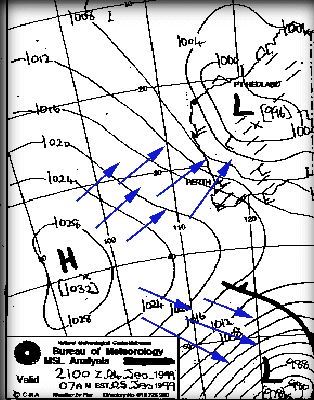
Bzzzzzzzt. Wrong! These are complex systems, and there's this other forces at work here, plus lets not forget
that the world is 3D and this is only a horizontal slice. Wind actually travels pretty much in the direction
of the isobar lines. And in the southern hemisphere they trave anti-clockwise around high's and clock wise around lows.
And the whole weather pattern moves (generally) in a west to east (left to right) direction. So the
wind actually blows around the high cell like this:
But don't forget. This all gets totally ignored by local wind effects such as seabreezes along the coast in the afternoon.
This synoptic chart is a joy to a wind fanatic living on the coast of Western Australia because this pattern means wind - and lots
of it - these cool winds also keep the maximum temperature down. In fact, the forecast for this pattern was:
TODAY'S MAX: 23 C (74 F)
Strong Wind Warning current.
S/SE winds 20/30kn in the morning, tending S/SW and strengthening
to 25/32kn in the afternoon.
The S/SE winds in the morning reflect the anti-clockwise direction of wind around the high, untill the afternoon when the thermal
induced seabreeze kicks in and changes to an onshore S/SW. Bliss!
But that low cell sitting up in the north is what can ruin it all. These low pressure systems descend in a southerly
fashion and bring with them hot and humid conditions. They are called troughs and generally spoil any chance of a seabreeze,
as indicated with this chart and forecast:

FORECAST:
TODAY'S MAX: 35 C (95 F)
E/NE winds 15/20kn, easing to 10/15kn by late morning. Winds shifting
NW/SW 10/15kn during the afternoon.
The capital city of Perth is going to be blasted with E/NE winds in the morning, brought in nice and fresh from the deserts,
and these winds are toasty - a maximum of 35 degrees C, and only a mild, if any, seabreeze. But wait - that's
a cold front approaching from the south west, and there's a good chance that this will push the trough inland and bring back the
seabreezes.
Generally speaking the thing to look for when looking for strong seabreezes is a new high cell
aproaching (following a previous high cell), or a tough moving inland and being replaced by a new high (extra windy!).
Cold Fronts...
Well, unlike seabreezes, cold fronts are active mainly during winter and come at any time of day or night. Cold
fronts do pass through during the other months, but there effect is usually not noticed by most. Like seabreezes, they come
in all sorts of flavours from simply making the sky cloudy to full on roof removing gale force winds. Cold
fronts, as the name suggests, is a line of cold air travelling along, generally west to east. As this cold air meets warmer
air, the warm air rises, and you guessed, causes the cold air to rush in and fill the space. Thus, the
actual 'front' of the front, called the 'squall line' is generally where most of the wind is.
Cold fronts are great when they come through, producing the locally famous 'Norwester'. Because the winds travel
clockwise around a low pressure system, the first taste you get is Northerly, but more often than not North Westerly. As
the cold front passes through these winds rotate around the compass, going from NW to W to SW, and maybe S. The
S part can get quite chilly because it dredging all the cool air from the antartic regions.
Not cold by UK standards, but enough to make your face numb. North Westerlies on the otherhand can be quite warm,
relative to the usual winter temperatures. The time it takes for the NW to SW transition depends on the speed at which the
front is travelling. Usually around a day, sometimes two.
Time to introduce another term - the pressure gradient. In the synoptic charts displayed above, the isobars have been
relatively spaced out, because the difference in air pressure is quite small over a large area. When we get a large
change in air pressure over a small
area - rig up your small sails/kites - it's gonna blow.
Checkout this chart - one of the windiest days in the winter of '98. Blue arrows indicate wind direction. See how close
the isobars are together. Also, remember that the entire frontal pattern moves from left to right (west to east),
but the winds blow in the direction of the arrows. I hope you can grasp the concept!
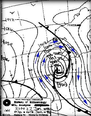
FORECAST
TODAY'S MAX: 19 C (67 F)
Gale warning current.
W/NW winds 30/40kn this morning with possible squalls to 60kn in
thunderstorms. Winds tending W/SW 20/30kn by early afternoon and
easing to 15/20kn this evening.
One of the best things about a cold front is that extra commodity - waves. As any sailor knows, wind generates
waves. The more wind, the more waves. If you've experienced a strong cold front, you know that they can get extremely
windy, as a consequence the waves can get quite large.
Here's another less extreme (for Perth, anyways) cold front. In Perth it blew around 20-30 knots, whilst the south coast
received 25-35 knots.
Stuff For Overseas Visitors...
Summer in Australia lasts from December through to the end of February, with the main windy bit being being December/January.
Of course, it can be windy during October to November, there's just more chance of it happening in Dec/Jan. Spring and Autumn
are not that windy due to the change of season. Not hot enough for seabreezes, and cold fronts aren't strong enough. (Generally,
sort of)
If you come down during winter, then June/July is the peak of winter. Winter really is pot luck for wind. 1 to 2 days
per week of winter action might be the norm. Sometimes, if we get a series of cold fronts one after another, it can blow
all day and all night for 3 to 4 days.
- How to save the weather graph images
Many people like to save the graph images for sending to friends, or collecting after a great session.
With the Bitmap images, this was a simple right-click "Save Image as..".
The new HD graph images you can't do this, so here are some options:
Option 1)
Specify you want the "original" bitmap graphs by clicking this link:
www.seabreeze.com.au/weather/settings/bitmap
Option 2)
Use a screen grabbing tool.
Windows has a snipping tool
, or
the Mac Grab tool
- Is Seabreeze.com.au setup for Day Light Saving?
- Red means danger, why use Green for strong wind?
Of course, for boating, fishing and some sailing, strong winds are a danger and can put you in mortal peril, so you might like to have strong winds represented by red.
Good news is that it's easy to change ..
simply visit this page to reverse the colours...
- Reversing the arrow colours fails?
Two solutions:
1) Check your settings under "privacy" in your browser, looking for references to Cookies.
2) If you've bookmarked the page, add "?rev=1" to the end of the bookmark.
i.e. https://www.seabreeze.com.au/graphs/wa.asp
becomes
https://www.seabreeze.com.au/graphs/wa.asp?rev=1
- Slow, Jittery or Lagging drawing of the weather graphs
The quick fix: If you just want it "fixed", and don't care how or why,
click here to restore the old graphs
. (Note: this won't work if you use "Incognito" or "Private" " browsing ).
Primarily we've found this to affect some FireFox and Internet Explorer 9, 10 or 11 browsers, or some browers on slow computers.
Why would they be slow, and what changed to make them slow?
We created the new HD (high definition) graphs for two reasons:
1) They are HD - they look much better
2) They are smaller and faster.
Literally 1/10th of the size so they use less of your bandwidth and draw quicker. All good so far.
We did extensive testing and found that the new HD graphs crash phones, so we disabled them completely for phones & tablets.
Which leaves laptops & desktop computers.
Some FireFox browsers and some versions of Internet Explorer 11 are really slow at drawing them; depending on your actual computer.
So what can you do about it?
Option 1)
U
se a faster browser.
Firefox/IE just don't draw HD graphs very quickly. Chrome and Safari do. We find
Chrome is the fastest at most things; certainly this site.
You can get Chrome from Google here
.
Option 2) Restore the old low-quality graphs
by clicking here to pre-select bitmap graph images.
If you change your mind and want the HD graphs back, click "Activate HD" at the bottom of the graphs page.
If you use option 2, and you're a fan of "Incognito" or "Private" browsing, then it will revert when you exit your browser (which is the point of incognito browsing). Read down the bottom on how to create a bookmark to make it persist.
Slow rendering on mobiles
Phone & Tablet browsers have an option to "Request Desktop Site", and when this option is turned on, your phone tells our website it's a big powerful computer, so we give it data for a big powerful computer.
As you can guess, sometimes it can't handle it, so if you're experiencing poor or slow rendering on your mobile, please do check that you have "Request Desktop Site" turned off.
What's the difference between the Bitmaps and the HD graphs?
Bitmaps (like photos) are pre-built on our servers, and delivered directly to your browser, and all browsers render them fast. The main challenge is that creating a really high quality bitmap (e.g. consider somebody with a 4K monitor) it takes a lot of data which means longer download times.
SVG (scalable vector graphics) are a series of drawing instructions - we deliver the drawing instructions and your browser draws them on your computer. Fast, lightweight, and looks great! SVG will draw at premium HD quality regardless of the display size. 200pixels to 4000pixels, as their name suggests, they are "scalable".
Switches for geeks
Adding "/bitmap" to any weather Url will force it to deliver bitmaps.
e.g.
https://www.seabreeze.com.au/weather/wind-forecast/perth
becomes
https://www.seabreeze.com.au/weather/wind-forecast/perth/bitmap
Other options include:
Adding "/alwaysBitmap" to any weather Url will force it to deliver bitmaps, and save a setting indicating you always want to see bitmaps.
Adding "/autoFormat" to any weather Url remove the above setting.
Links:
Force Bitmaps:
https://www.seabreeze.com.au/weather/settings/bitmap
Unforce Bitmaps:
https://www.seabreeze.com.au/weather/settings/autoFormat
If you need any further assistance, please do contact us via the Contact link at the bottom of the page.
- The Beaufort Scale
The Beaufort Scale
|
Beaufort scale number
|
Descriptive term
|
Units in km/h
|
Units in knots
|
Description on Land
|
Description at Sea
|
|
0
|
Calm
|
0
|
0
|
Smoke rises vertically
|
Sea like a mirror.
|
|
1-3
|
Light winds
|
19 km/h or less
|
10 knots or less
|
Wind felt on face; leaves rustle; ordinary vanes moved by wind.
|
Small wavelets, ripples formed but do not break: A glassy appearancemaintained.
|
|
4
|
Moderate winds
|
20 - 29 km/h
|
11-16 knots
|
Raises dust and loose paper; small branches are moved.
|
Small waves - becoming longer; fairly frequent white horses.
|
|
5
|
Fresh winds
|
30 - 39 km/h
|
17-21 knots
|
Small trees in leaf begin to sway; crested wavelets form on inland waters
|
Moderate waves, taking a more pronounced long form; many white horses are formed - a chance ofsome spray
|
|
6
|
Strong winds
|
40 - 50 km/h
|
22-27 knots
|
Large branches in motion; whistling heard in telephone wires; umbrellas used withdifficulty.
|
Large waves begin to form; the white foam crests are more extensive with probably somespray
|
|
7
|
Near gale
|
51 - 62 km/h
|
28-33 knots
|
Whole trees in motion; inconvenience felt when walking against wind.
|
Sea heaps up and white foam from breaking waves begins to be blown in streaks along direction ofwind.
|
|
8
|
Gale
|
63 - 75 km/h
|
34-40 knots
|
Twigs break off trees; progress generally impeded.
|
Moderately high waves of greater length; edges of crests begin to break into spindrift; foam isblown in well-marked streaks along
the direction of the wind.
|
|
9
|
Strong gale
|
76 - 87 km/h
|
41-47 knots
|
Slight structural damage occurs -roofing dislodged; larger branches break off.
|
High waves; dense streaks of foam; crests of waves begin to topple, tumble and roll over; spraymay affect visibility.
|
|
10
|
Storm
|
88 - 102 km/h
|
48-55 knots
|
Seldom experienced inland; trees uprooted; considerable structural damage.
|
Very high waves with long overhanging crests; the resulting foam in great patches is blown indense white streaks; the surface of
the sea takes on a white appearance; the tumbling of the seabecomes heavy with visibility affected.
|
|
11
|
Violent storm
|
103 -117 km/h
|
56-63 knots
|
Very rarely experienced - widespread damage
|
Exceptionally high waves; small and medium sized ships occasionally lost from view behind waves;the sea is completely covered with
long white patches of foam; the edges of wave crests are blowninto froth.
|
|
12+
|
Hurricane
|
118 km/h or more
|
64 knots or more
|
The air is filled with foam and spray. Sea completely white with driving spray; visibility veryseriously affected
|
- The forecast images are not updating?
Why is it happening - usually to do with "cached" images - your browser tries it's best to save images so they are re-downloaded over and over, and it sounds like this might be what is happening to you. We have special "cache-busting" techniques to get around this feature which works 99.9% of the time.
To fix the problem, try a "forced" refresh: If using Microsoft IE, or Firefox, hold down the Control key whilst clicking the refresh icon/menu option. If you're using a different browser, have a hunt around the menus and options pages for features related to "Clear Cache"
- What does the wave height represent?
- What is the Beaufort Scale?
|
Beaufort scale number
|
Descriptive term
|
Units in km/h
|
Units in knots
|
Description on Land
|
Description at Sea
|
|
0
|
Calm
|
0
|
0
|
Smoke rises vertically
|
Sea like a mirror.
|
|
1-3
|
Light winds
|
19 km/h or less
|
10 knots or less
|
Wind felt on face; leaves rustle; ordinary vanes moved by wind.
|
Small wavelets, ripples formed but do not break: A glassy appearance maintained.
|
|
4
|
Moderate winds
|
20 - 29 km/h
|
11-16 knots
|
Raises dust and loose paper; small branches are moved.
|
Small waves - becoming longer; fairly frequent white horses.
|
|
5
|
Fresh winds
|
30 - 39 km/h
|
17-21 knots
|
Small trees in leaf begin to sway; crested wavelets form on inland waters
|
Moderate waves, taking a more pronounced long form; many white horses are formed - a chance of some spray
|
|
6
|
Strong winds
|
40 - 50 km/h
|
22-27 knots
|
Large branches in motion; whistling heard in telephone wires; umbrellas used with difficulty.
|
Large waves begin to form; the white foam crests are more extensive with probably some spray
|
|
7
|
Near gale
|
51 - 62 km/h
|
28-33 knots
|
Whole trees in motion; inconvenience felt when walking against wind.
|
Sea heaps up and white foam from breaking waves begins to be blown in streaks along direction of wind.
|
|
8
|
Gale
|
63 - 75 km/h
|
34-40 knots
|
Twigs break off trees; progress generally impeded.
|
Moderately high waves of greater length; edges of crests begin to break into spin drift; foam is blown in well-marked streaks along
the direction of the wind.
|
|
9
|
Strong gale
|
76 - 87 km/h
|
41-47 knots
|
Slight structural damage occurs -roofing dislodged; larger branches break off.
|
High waves; dense streaks of foam; crests of waves begin to topple, tumble and roll over; spray may affect visibility.
|
|
10
|
Storm
|
88 - 102 km/h
|
48-55 knots
|
Seldom experienced inland; trees uprooted; considerable structural damage.
|
Very high waves with long overhanging crests; the resulting foam in great patches is blown in dense white streaks; the surface of
the sea takes on a white appearance; the tumbling of the sea becomes heavy with visibility affected.
|
|
11
|
Violent storm
|
103 -117 km/h
|
56-63 knots
|
Very rarely experienced - widespread damage
|
Exceptionally high waves; small and medium sized ships occasionally lost from view behind waves;the sea is completely covered with
long white patches of foam; the edges of wave crests are blown into froth.
|
|
12+
|
Hurricane
|
118 km/h or more
|
64 knots or more
|
The air is filled with foam and spray. Sea completely white with driving spray; visibility very seriously affected
|
- What is the difference between waves and swell?
Swell is the regular longer period waves generated by distant weather systems - think of a rock thrown in a pond, and you'll see swells.
Waves & Swell are often used to mean the same thing .. in common language many like to think of "swell" as the regularly spaced lumps that approach your local surf spot, and "waves" as when they break/something to stick your surfboard on.
Wave height (trough to crest) refers the average height of the highest one-third of the waves.
- What's the difference between Swell, Waves & Seas?
The swell then travels until worn out by time, distance or obstacles. Generally, "Swell" refers to open ocean waves, "Waves" are what people want to go stick their surfboard on.
Seas can sit "on top" of a swell, and ruin a surfers day out. They are the localised chop, that given enough time and wind energy would ultimately turn into swells.
An example:
Consider a nice windless day & you're looking at your local surf break.
6 foot swell, no wind, no seas:
What you'll see is a surfers dream. A milky smooth water surface and crystal cylinders.
6 foot swell, no wind, moderate seas:
The swell is still solid, but you'll notice that there's no milky smooth water surface any more. There'll be chop, and wavelets mucking up the waves.
So, seas are the smaller waves/chop that are present within the swell. Depending on how they're generated, depends on how much it can take away from a surfers day.
- When I reverse the arrow colours, it doesn't stick?
Reverse Arrow Colours
page, and it's not working, that would be because you've got cookies disabled.
First solution is to enable cookies (look under the options menu of your browser), or if not happy to do that, add "?rev=1" to the weather page url.
e.g.
If you're visiting
https://www.seabreeze.com.au/graphs/wa.asp
append it to the url :
https://www.seabreeze.com.au/graphs/wa.asp?rev=1
- Where are the wind readings for XYZ taken from?
Unfortunately, the first two types prevent us from revealing the physical location of meters. Sorry!
- Where do I find Sea Temperatures?
- Why are the forecasts so accurate?
- Why are the forecasts so wrong?
It's true that we do stuff up the forecasts now and again. Weather is far from being a perfect science.
Given the movement of the weather up to the point of issue, the forecast is predicting the highest probability of where the weather will head next. Unfortunately there are many variables that alter the course of the weather, so it's important to understand that a forecast is a probability, not a certainty.
We humans endeavour to predict bank interest rates, stock exchange prices, property prices, other peoples behavior and of course, the weather. We collect as much existing information as possible, apply formulas and couple this with past experience to offer a probable result of what might happen. Forecasts can be wrong, and this may be due to faulty, insufficient or incomplete observations, rapid changes in conditions, errors (both human and computer) and many more reasons.
Interestingly, it's only in the last 50 years of human existence that weather forecasting has reached the level of accuracy now experienced.
Some interesting article:
Simple view of how the weather works
History of weather discovery.
- Why are the wind readings wrong?
Imagine you're on your way out to install a wind meter for your favourite location. Your first obstacle is finding a suitable position that is nicely exposed to the wind from all directions. Next is to make sure it's high enough so that surrounding terrain doesn't upset the reading .. oh, don't forget avoiding vandals, and then you've also got to get electricity and communications to it. Other needs include payment for securing a lease of the site, and how long it's available. What all this adds up to is that not all wind meters are in perfect conditions. Some will favour the most common direction, others have a wind meter but are more biased towards recording accurate temperature or barometric pressure.
What we're saying is that if you're after perfection in measuring the wind, you're going to be disappointed (or at least a little bit upset).
Best Bet: Over time, you'll learn how a particular meter close to your favourite spot behaves.
- Why do you use green arrows for strong wind?
Of course, this doesn't suit everybody, so you can reverse them easy enough to accommodate the "standard" red is danger colouring.
Visit
Reverse Graph Colours
page.
- Why do your arrows point the wrong way?
We had two options for the direction: Direction the wind is blowing, or direction the wind is coming from .. we chose the first because to us it made more sense.
A wind vane only points into the wind because that physically is the only way it will work, but in the computer world we're not hindered by that.
If you
check the maps
(maybe you already have) you'll see the map makes plenty of sense to show which way the wind is going .. a Westerly wind blows across the map from west towards the east, so the arrow points towards the right.
Swell charts and many other meteorological readings all show arrows in the direction that something is going .. i.e. it would look strange to draw an arrow of where waves were "coming from" .. It's only wind that sometimes has the "lets point the arrow at where it came from" concept, and that's because (we think) of wind vanes.
Hope that helps understand the reasoning behind it all!
- Why do your predictions differ from other sites?
We use our own algorithms, and provide different forecasts to other organisations.
Nothing quite like a second opinion? :-)
- Your forecasts are different to the BoM?
 Forums
- About the new layout
A big thankyou to all the crew in the forums who provided feedback and testing, to help evolve the design.
Two things were driving the change .. mobiles & wide screens.
The new facelift includes support for (and has been tested on) over 15 different platforms, including PC's, Mac's, the Apple range of iPhones & iPad's, as well as popular Android mobiles.
When visiting Seabreeze.com.au on your mobile, the site will automatically adjust itself to fit on your devices screen. Navigation issues exerienced on Androids have been fixed.
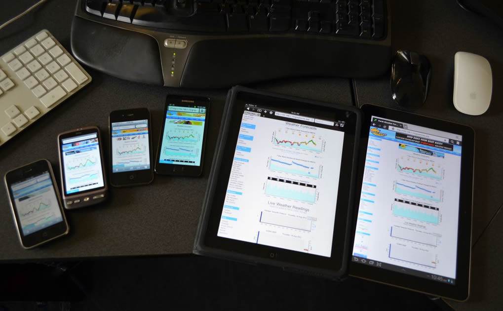
The readability change affects primarily the Forums and Buy & Sell to a "Fixed Width" design. Over 95% of desktop computers have displays that are 1250 pixels or more, wide. On 27" monitors, stretching text across the whole window causes the "Watching the tennis" effect, where you eyes have to travel "vast" distances left/right to read the text. You could easily tweak this by resizing the browser window to your preferred with, but that's a pain, and with the move of many desktop browsers becoming 'full screen' (e.g. Windows 8), we needed to make a change.
This fixed width mode will suit most people, and is highly popular around the web, and well proven on sites with 400+ million users, such as Facebook and Twitter. We've provides some action photography to fill in the blank areas (for those on wide screens), which look great, and will soon be asking for submissions so that locals can feature their photos in this area.
If, for some reason, you prefer the older wide screen format, the option exists (find it a fixed/wide link at the bottom of most pages) where you can return to the original 'stretched view' layout. Some say you can't please all the people all the time, but we've given it our best shot to accomodate all.
There are also a bunch of updates/fixes to the forums and classifieds, and a new taller menu so you don't need to be so pixel accurate with the mouse to choose things.
In summary, I hope you really enjoy the new layout - we've been using it for a quite some time, and really enjoy it..
Change is good .. check the original look from 1997 when all we had was WA weather and an about page!

- Can you delete me?
A simple rule of the internet is that if you don't want it read, don't write it down.
- How come so & so can post XYZ, but mine got deleted?
Hopefully you realise there is a collosal amount of posts, and it's a massive task to keep on top of who writes what and keep it all clean / within the forum policy.
Just because a similar post to one that you wrote hasn't been removed doesn't mean "we let that one go, but targetted you", it generally means we've not seen the other one.
Let us know if you feel you've been hard done by. Ultimately, the goal of the forums is to create a friendly place and a great community vibe!
Help us make it a great place to visit!
- I'm disgusted with what someone has written!
If it is truly disgusting (as in "should be deleted"), then above each post is a small flag:

Click this and it will alert the moderators of the post. If a moderator is online at the time, they will investigate, otherwise, next time one logs on they'll have a look. Please be patient.
If you disagree strongly with the content, but would rather leave the censoring to the moderators, maybe use the thumbs


to cast your vote against it.
Rest assured both methods will not reveal your actions, and we will not contact you in regards to reports or votes.
The goal of the forums is to keep it a fantastic place to visit, and with your help / feedback we can keep it that way!
- What are the forum rules?
here
. :-) Hours of fun for all the family.
- What are the thumb up/down icons for?
They are nothing more than a visual cue of others opinions. Imagine you're standing around in a group, and someone says something. Some in the group will simply "raise their eyebrows", or frown, or laugh or .. they will make a visual indication, rather than say something. Sometimes it suits.
Forum readers can have their say without having to post.
They also serve another excellent purpose. Once a post receives a certain number of thumbs down, it pops up on our screens as needing attention. Sometimes "off" posts need context and can't be identified by obscene words, etc. The thumbs system helps your hosts keep the forums friendly and a welcome place to visit.
- What is the report content flag?
We scan all content daily, yet with the vast amount uploaded each day, it's highly possible that some content will be missed.
Help us remove inappropriate material by clicking on the flag icon. We won't write to you about it, and your login will not be revealed, or even contacted.
All you need to do is report it, and we'll do the rest!
You'll find this flag:

in member profiles, the forums, the photo gallery and many other spots.
- Why can't I edit my post?
We used to have a longer editing window, but we found it was mis-used by folks to completely change the meaning of their post (as opposed to fixing typos/clarify meaning). This made reading the forums difficult, especially when a 100 words of post have been replaced with "." !
- Why did you ban me for spamming the forum?
have spammed the forum and are struggling to come to grips that your offer to buy Nokia Phones or Nike shoes at discount prices are not considered good content.
Ok. Maybe you're not selling dodgy phones, but maybe you're selling shirts on your new T-Shirt business. You've had a few beers on a Friday night and are registering on all the forums you can to share with the world your fantastic new business!
It's a great idea, but unfortunately, there's another 300 people just like you also keen to promote their business. Of these 300, around 298 aren't spamming forums, and the other 1 hasn't been able to work out the technology yet.
You can get amongst our full policy on
advertising in the forums
here
- Why don't you moderate the forums?
We do! However, occasionally you might read a post that is offensive, and wonder why it's still there.
Most of the time (i.e. 99%) people use the forums to share experiences & help one another. It's very rare that you'll get someone who's not themselves either because of stress, alcohol, agendas .. who knows.
These people may write dodgy stuff and it's there for all to see, generally because a moderator hasn't got to it yet. Help out by clicking the Vote thumbs or the Report flag to alert us.
Help us help you & the community by reporting / flagging posts that you believe are inappropriate.
 Classifieds
- Buyer didn't buy! Can I reinstate my advert?
You had the deal, but for some reason, the buyer has backed out of the transaction. Problem is you've taken the item off the site, and you want it back online, and you're concerned you might need to pay again.
No dramas -
Send us an email
with your story, and chances are we'll re-instate your advert, no charge.
- Can I trust the buyer/seller?
Much like any classifieds listing service, we publish adverts, and are unable to certify the validity of sellers, or buyers.
However there are some things you can do to make it safer:
Check their profile:
- how long have they been registered on the site
Make verbal contact:
- in this age of email, you can still use your personal skills to talk with the person via phone to verify details and see what kind of character they are.
Establish expectations:
- is the seller/buyer an offshore worker who dissappears for two-three weeks at a time and doesn't access his email?
Do they only check their email once a fortnight? Are they computer literate? No point getting all upset about no email reply for reasons you could have worked out beforehand..
Delivery options:
- Does the buyer pay, and then the seller ships, or the seller ships & the buyer pays on receipt? You'll need to sort this out upfront.
** Remember that Australia Post at most will refund you $100 if they lose your package. i.e. You can register it for delivery, but if it doesn't roll up (i.e. they lose it), the most they'll give you is $100. Not much consolation for your $1000 package. A hard lesson to learn.
*
* PayPal have all sorts of caveats about "refunds", so make sure you understand their policy, as you're more than likely not covered. A hard lesson to learn.
** COD (cash on delivery) is a great option - recipient pays upon receipt of goods.
Australia Post is a massive service. In our experience via this site of shipping goods for 3 years, they very rarely lose things, but it can & does happen - be prepared for it, and be prepared for a 2-3 week wait whilst they investigate.
The wheels turn slowly.
Insurance for $15 sounds expensive when you're standing at the counter, but is may well worth it should it go wrong.
Doing interstate deals really does come down to you speaking with the seller, getting as many photos as possible and trusting/taking the risk accordingly.
- How do I find my listing?
Find your listings by:
From your list of your adverts (if you have more than one), click on the advert of interest.When viewing the advert, you will see a large option box at the top of your advert where you can choose options such as removal, updating images, editing the text, reducing the price etc.
- How do I remove my listing?
Find your listings by:
From your list of your adverts (if you have more than one), click on the advert of interest. When viewing the advert, you will see a large option box at the top of your advert where you can choose options such as removal, updating images, editing the text, reducing the price etc.
- How long does my advert stay online?
To avoid the classifieds getting stale, however, we will email you after a period and ask you to "refresh" the advert if it is still for sale. We'll send you an email with a link which you click to keep your adverts online.
If you believe your advert has unfairly expired, please do let us know & we might be able to resurrect it.
- How much to courier something?
- I paid but can't add my images!?
If you visit the home page of the Buy & Sell, there will be a link to enter your advert.Alternatively
visit here to check the status of all your adverts
.
Another reason can be when you pay via PayPal .. sometimes they send us an "E Cheque" which is caused by buying when you have no funds in your PayPal. Once you clear the funds in PayPal, they clear the funds with us, and your new advert becomes available to be entered. Again - visit the "Buy & Sell" home page and you'll see the link to enter your new advert, and we'll also send you and email.
- I've posted my add, but it's still not appeared?
- Paid by EFT - where's my advert?!
An alternative is to use Credit Card or PayPal which both offer immediate access.Once your transaction has been confirmed, you'll receive an email from us. If you think it's been a bit long (over 2 days), please feel free to send us an email via the
feedback page
.
- Putting your email in an advert
The reason we do it is because your email inbox will soon fill up with spam, and we've had plenty of emails from people who've suggested that we've being passing their email out to spammers. (Which we don't). The "Spammers" of this world write software programs called "spiders" which are automated programs that scan internet sites like this looking for any text that looks like an email. When they find an email they gleefully add you to their daily mailouts and you can now look forward to a daily feed of unwanted emails regards your masculinity, depression, nigerian money scams, rolex watches and more.
For your sake, and ours, it's best not to publicly publish your email on any website! :-)
 Gallery
- How can I use a photo from the gallery?
Click on the members name, and that'll take you to their profile. From there you'll find an "Email Member" link where you can make an enquiry, and possibly acquire a higher resolution image.
- How do I delete a photos I've uploaded?
- How do I find photos I've uploaded?
|

