Weather | Buy&Sell | Forums |  |
Weather | Buy & Sell | Gallery | Forums | |
Is there anything especially difficult about sailing out the heads of Port Philip Bay? I may be doing it soon and someone warned me it can be.
If you choose your time and weather its ok but if not its terrible.
I have done it in a TS no problems but it was a nice day and slack water.
The fact you are asking the question means there is a lot you should learn before attempting it. And please note I don't mean this in any disrespectful way. It's just that whilst doing it at the right time will make you wonder what all the fuss is about, getting it wrong can lead you into horrible trouble.
The Cruising Yacht Association of Victoria's "Cruising Victoria" book has excellent coverage of the Heads (and everywhere else along the Victorian coast, the Bass Strait Islands, and the northern Tasmanian coast). You will also find many opinions and resources simply by googling.
If you care to pm me I would be happy to email copies of some good material.
Cheers, Graeme
Hi Trek,
Have a look at this thread 'Port Phillip Bay Heads Crossing'
pm me for a very useful document "RBYC Getting through the Rip"
regards,
Allan
If you are exiting you have a lot of control over your timing. If you are entering you have to time it and be prepared to wait. This could mean waiting outside on deteriorating weather.
The tide is unusual there too and you need to wait for slack water. This is advertised by Ports. But yes not an undertaking to be taken lightly.
+1 for wongaga's comments.
I have taken my TopHat out solo a couple of times when tides are favourable, and it is easy if you follow the basic rules.
I recommend taking this tour, and listen carefully !!
www.orcv.org.au/index.php/training/rip-tour-of-port-phillip-heads
In good conditions, the leads are easily visible; but you must understand the geography of the RIP and the wind and tides. I was contemplating going out on Sunday, but the tides are all wrong.
www.bom.gov.au/australia/tides/#!/vic-the-rip
Thanks all for info. I was intending to wait for good weather and go near top of tide. Having sailed around NZ and in and out of some nasty places I learnt the value of local advice. One bay had a 5kt outgoing current in channel and my 39ft boat at the time could only do 6 kts. If bow was dead head to current we could do 1kt but it was near doom to let the bow swing off least the current would then broach the boat and then no control and nasty things to hit. The most exciting part was at top of channel it was necessary to turn across the current to get into the marina. So go upstream first so while the boat is washing broadside downstream you gun it to get in. Got into there thanks to local advice on the vhf before we tried. But we had run out of beer and didnt want another cold dark night at sea (unhappy gf) and had no choice ![]()
Agree with saintpeter - the ORCV's Rip Tour is a great way to get up close and personal with the Rip in complete safety and to learn from the very experienced tour leader, plus it's a lot of fun.
A few main points: Slack water isn't at the time of high / low water but is delayed aprox 3 hrs. I was told by the local boaties to go by the time of slack water at williamstown as a guide, given on seabreeze.
www.bom.gov.au/australia/tides/about/p4a-port-phillip.shtml
www.ppsp.com.au/passage-planning-/TidesCurrents.html
There is an easterly set so watch for that and know the position of Corsair Rock. Wind against tide is to be avoided especially outgoing tide with wind from south westerly to south easterly. I always have my motor on before the approach to the heads even when sailing, but that's just me.
Thank you all for advice. Being shipwrecked is not my intention! I truly value local advice and when I get closer to the date if we are going I will study up. Cruising Guides are fantastic but sometimes can be out of date. One time at Box Head Broken Bay where I sailed in and out many times even in Southerly (because I was a local) one of the critical channel markers disappeared for two months leading incoming boats onto a sand bar. I knew where to turn, as my mates did, but the missing marker caused some grief for others until it was put back. Obviously the cruising guides didn't know about the missing marker only where one should have been causing great confusion to incoming. Lucky it was only sand. Hence value of local knowledge.
Two things to watch for ,slack water and Bass Strait weather more importantly a couple of days before. Last one I remember was
1 Dec. 2010 ? The three men died after their pilot launch George Tobin was swamped in 'The Rip' after flipping ... in a 1,600 hp pilot boat - the most powerful of its type in Australia.
Surprisingly, I was told more boats and yachts was lost entering
Western Port.
I cannot emphasize enough:
DO NOT TRANSIT AT THE 'TOP' OR 'BOTTOM' OF THE TIDE - IT IS SLACK WATER THAT YOU ARE AFTER.
Refer to my previous post for the official web page for times of SLACK WATER AT THE RIP.
Having said that, it is possible to ENTER the bay during a flood stream if conditions are favourable, i.e. not wind-against-tide. And the lead markers will not move - they are lighthouses!
Thanks all especially for safety concerns but dont worry I should clarify what I said earlier. When I said go at high tide I know there can be a delay on tidal charts vs the stand of the tide - slack water. And all these places have a best time for tides vs current vs wind. Many places I ve transited are like that, Lake Macquarie entrance for one. In my homeland the Manukau Bar which we called the washing machine. I haven't lost a boat or passenger (in 40yrs of sailing and teaching sailing) and dont intend to. That's not to say I couldn't if care not taken. A worry at The Rip would be shipping. All else seems like normal big tidal flow channel. Point noted the the channel markers wont move ![]()
secondly : recommended transit for small crafts is west of the shipping channel.
in case, coming from east there is need to cross channel in same stage,
ones we had heavy traffic over 10 ships going In - Out , you coordinate timing with the Rip control.
unless you on power boat, ships going Out really crank up the speed.
To save a bit of repetition.......
www.seabreeze.com.au/forums/Sailing/General/Port-Phillip-Bay-Heads-Crossing?page=1
And some more reading for you. I will shut up now.
www.cruisersforum.com/forums/f121/sailing-the-rip-into-port-philip-victoria-146690.html
yes Track, ships going out, ones they line up crank up the speed , I can surf on it with my T/S.
this is one of my expirience , transfer my T/S from P P to Westen p.
fereezing winter 3am , thick fog, left Quenscliff , doing 4.5 knots, line up Longsdale edge of the channel.
ship going out to control...there is something withing the channel
me. introduced myself ...order leave the channel ..stay outside ,,,,,perhaps I use wrong channel contours
me 1/2 later call control ...any chance to cross channel going east.
control. you see on radar lots of traffic, keep going outside the channel
me. copy that, I have GPS only please let know when OK to cross
one more hour , ship coming from west....to control...Let that boat cross , don't push him to Tasmania.
control to me.....ok to cross, good morning .
Have been through heads quite a few times albeit most in ORCV races night and day starts. Coming back work out average speed needed to get there at right time and stick to it even if the iron sail is needed. Nothing worse than getting red lights and having to sit it out.
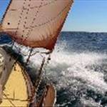
First time was a bit scary on slack Tide with whirlpools everywhere.
Last time got sea sick . Only time ever seasick.
Its no big deal IF you follow rules and let authorities know when your close and ask questions if in doubt. Tell them what your on and is it safe to cross. If embarrassed to do on radio ring them. Ring them before hand they are really helpful
Used to be Point Lonsdale lighthouse.IMO get admiralty chart of heads.
This was before GPS etc. and when directed what channel to use we would line up appropriate lights /Towers looking behind when exiting ,Take compass reading and stick to it. Control tower control 3nm out to sea.http://www.yachtingaustralia.com.au/site/yachting/rycv/downloads/the%20rip.pdf
+1 to all the experts and links.
The key words to remember are FOUR FINGERS WEST. Unless you have perfect wind/tide or a lot of experience, do not use the Clarkes Beacon Transit - if you leave your rudder on Corsair Rock you will not be the first.
And btw, the 'control' that was referred to is 'Lonsdale VTS' on VHF 12 - and they are in Melbourne and cannot see you or the RIP. They do however know all the shipping traffic, which is helpful, especially at night.
I suppose this is contradictory to the above but worth saying anyway. If heading east when going out the heads, there's nothing wrong with taking a course just eastward or outer edge of the East Chanel keeping in mind Corsair Rock weather permitting of course.. We do it when heading to Westernport or the Prom.. It can be rough due to tidal influence and wind for a few miles out so keep in mind if you exit using 4 fingers west at slack water then plan to go east, on a rough day conditions could get worse as you go east if you are not far enough out.
Often the locals go out from the east as it tends to be not as rough and the old fishermen would often take a route between Corsair and Point Nepean. Locals have been wanting a light on Corsair for years and I think this would be a great assistance to visiting boats. I know the area reasonably well because I surf at the heads and have had a good look around when in various conditions and been through on others boats bigger than mine when conditions are less than ideal. One memorable trip was on a spectacular day, we went outside near Corsair and across to the Lonsdale Pier, dropping the pick just north of the pier at slack water before the flood.


Many sailing courses teach as a rule of thumb that the tidal current is lowest at the time of High Water and Low Water. That all seems logical and intuitive from the rule of 12ths. However, this only holds true for open oceans. For coastal rivers, basins and harbours local features will more than likely restrict the horizontal flow of water resulting in the time of slack water lagging behind the time of high or low water and general rules of thumb can be dangerously misleading. Port Phillip Bay is particularly noteworthy not only for the timing of slack water but also because of the effects that shoals and channels have on the movement of water after entering or when leaving the Bay. Having gone through the Port Phillip Heads on two occasions it is definitely an experience as is crossing Wide Bay Bar at near midnight with Morning Bird and Cisco. That is, it is an adventure not to be missed if well planned. The following may be helpful and more can be found at http://www.ecomaritime.com/demonstration/tidescurrents.html
Port Phillip Heads
Due to the restriction of the tidal range within Port Phillip caused by the relatively narrow entrance, the tidal stream in the vicinity of the Heads does not turn at high and low water.
The force of the tidal streams depends upon the relative water levels inside and outside Port Phillip. The greatest difference in levels occurs at about the time of high and low water at Port Phillip Heads. This is when the inward and outward streams run at their strongest, up to six knots under normal conditions and may exceed nine knots in extreme conditions. Slack water at Port Phillip Heads occurs at about three hours before and three hours after high water, which is when the levels inside and outside are the same. The ingoing stream runs from about three hours before to about three hours after high water and the outgoing stream at other times.
On the average, it is high water at the Port Phillip Heads three and a quarter hours before that at Williamstown and slack water at the Heads when it is high or low water at Williamstown.
Tide Stream Signals
Tide stream signals are shown by night at the Point Lonsdale Lighthouse below the main light. Flood stream is denoted by one fixed green light for the first half of the flood and two fixed green lights vertically aligned for the second half of the flood. For the ebb stream, the first half of the ebb is denoted by one fixed red and the second half by two red lights vertically aligned.
Note: Tidal height information can be obtained by contacting Point Lonsdale Signal Station.
Never go anywhere near Corsair rock ! Get expert advice before transiting the rip .
simple rules apply for all,
locals wandering all over place, sneak around from Portsea
along the east transit, even fishing in the middle of the channel.
seen it many times , not for rest of us.
Looking at the chart it looks to me you would really have to stuff your Nav up to go near Corsair Rock.
Why are people so concerned about it?
Coming in from the north (east)and wanting to go up the South Channel and you don't want to go across to four fingers and turn right you must line up the markers ( Clarke's Beacon transit) and NOT try and cut the corner otherwise Corsair could get you.
 SS Time