Weather | Buy&Sell | Forums |  |
Weather | Buy & Sell | Gallery | Forums | |
all bad, for some and seriously good for those south of the bad.
better break out the mops, buckets, cyclone shelters and 3m sails. a biggy is being forecast. seriously hope not.
it's not like we need anymore water.
Clonics it is !!!
Home on Monday, woo hoo !!!
Gonna be a road trip soon. Give yer a lift Gesty if you are interested.
road trip..... just go to my local, it's closer...
it's not anthony but the one after that, should come into view around tuesday.. ![]()
Mmm, I like open water better.
Have a few weeks off now, so plan to get stuck into some sailing.
I travel so much for work these days, a bit of a drive for fun seems quite reasonable.
Probably doing Ingham for April/May, so should get some sailing in up there. I'm going to check out Forrest Beach on a short trip soon, which is very close and do-able after work or on split shifts.
Hopefully it is a good proposition for sailing.
What is the following forecast ?
Is it another clonic, or another sub-tropical low ?
ecmwf has a big cyclone entering the coral sea around tuesday and making a bee line for mackay.
some models have it a little further north with the outskirts maybe brushing fraser island.
usually big cyclones move tend to have some element of south in them as they generally tend to head towrds the poles.
only time will tell as to what happens. it could amount to nothing or it could go off.
unfortunately qld just doesn't need any more rain.

Interesting.
Queensland is going to get more rain though, I think we can be sure of that, and soon, by the looks.
Anthony is likely to cross the coast and dissolve into tears.
Looks like I might get the wave boards and the small sails wet for the first time in years.
Typical, we've got 30 knots atm at Sarina and I've lost my GPS![]() . Sounds like my smallest sail 5.3 is gonna be way too big.
. Sounds like my smallest sail 5.3 is gonna be way too big.
Thanks for the update gesty.
Looks like he's gonna spank Townsville.
Good sailing through the central coast today.
It's a bit like the cartoons of the big fish chasing the little fish, and Australia is the bait !!
Has the big sucker got a name yet ? Looks like a mo-f**************.
i had a look on the noaa site.
if i got this right. anthony may end up being called ex trop cyc ant soon, but note that the bom still have a cyclone warning in place and winds are still cat1 in strength. plus it could intensify again, who knows, unpredictable things.
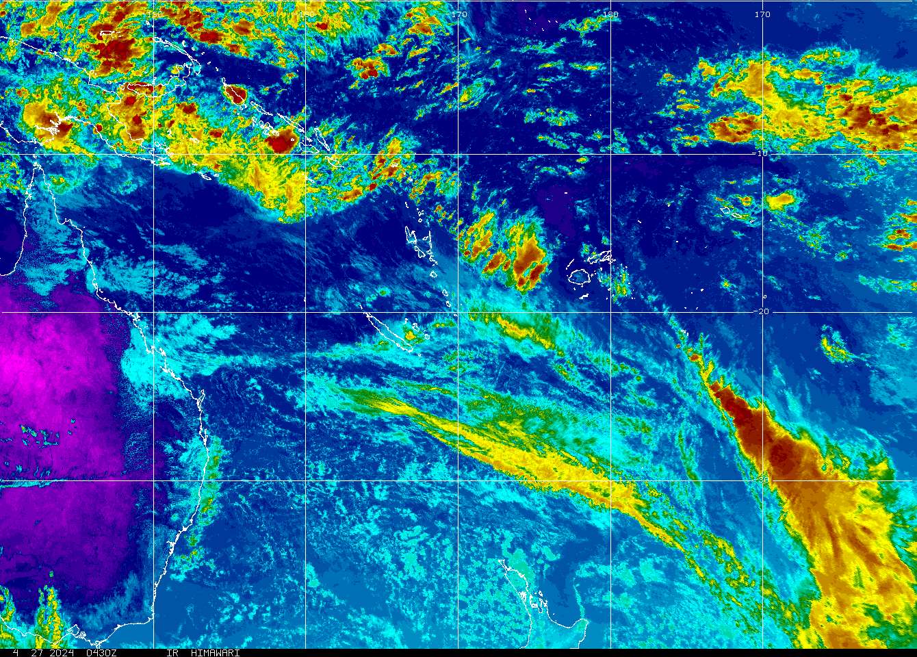
our new friend has not reached cyclone strength so is yet to be named but is intensifying. you can see by the amount of red that there is plenty of rain and therefore lots of fuel, the steering winds for this new low are west i beleive.
SH902011 - INVEST
rammb-data.cira.colostate.edu/tc_realtime/
JUst looked at the BOM site.
I saw use of Cyclone Yasi, which seemed to be referencing the Fiji low.
Either way, lots of wind and rain due for the tropical coast.
you could be right ken but it's not a cyclone yet so no name. maybe that name is the next name on the list.
here is the vanuatu met updates.

isnt that what happened in 74? - there had been a wet summer & about now an ex tropical cyclone hit up nth drifted south & sat still untill all the water fell out? - it is a freakign nightmare - I am suprise how still and calm the weather is outside of the storm
remember all the dramatics the media put on for all the extreme weather events that were supposed to happen to qld during the post christmas period 2010, which ended up being the most tame summer ever? they were well and truly out by a year
holly **** anthony kicked in. cat 2 ![]()
wind got up to 67knots. sitting over bowen now.
So, what's it's name ? Just checked, it is Yasi, so unless I've come down with a case of clairvoyance, I must have seen it somewhere.
The forecasts were bang on with Anthony.
It's been a long time since cyclones crossed the coast so quickly and directly.
Remember when they were always given female names because they were so unpredictable ? That was pre-PC.
Then, in the 90's, they did the J-curve away from the coast.
This year they just seem determined to commit suicide by coastal crossing.
Looks like Qld is gonna get another bath, whether it needs it or not.
yeah, it is yasi, not sure where you saw it but at that time it wasn't a cyclone.
just read from bom dude that yasi is expected to hit as a min cat4.... lookout!
Yeah, it seems like someone was jumping the gun a bit.
It's gonna be a big system. Sitting in the terminal at Mt Isa waiting to board my flight home right now, and I'm looking forward to sailing soon.
The last one that big I recall was 1997, sat over Fiji for 3 weeks and I sailed a 5.0 every day at EH for that time. It did not move though, and stirred up too much cool water and killed itself.
Later that year was a major low that tracked down the coast and flooded everywhere.
^ massive!
fingers crossed the floods aren't to bad after yasi lands. look at the size of it on the mtsat image a few posts up. looks almost as big as queensland.
this one is the sat image of the coral sea.
thought i should put up the bom track map. i hope i've linked these to maps that will update. if not i'll delete the post.
i reckon that secret gladstone world class reef break will be going orfffffffff.....
things starting to ramp up now. local councils are putting up info on their websites re evacuations etc due to floods and storm surges in the areas on the bom track map.
Sounds like the real deal! Thanks for the update gestalt!. I feel that the gc might have to keep a close look at this system. The intensity of the low and the calmness of the high just doesnt sit right?. Wait and see I suppose. would like to hear other peoples thoughts on this one!
we don't have anything to worry about south of rocky at this stage other than missing out on some fantastic surf.
yasi is expected to head into the centre of australia according to the bom. that in itself is incredible. normally cyclones die over land.
the item that stands out to me in the youtube clip is the use of the words "very large storm surge".