I love the simplicity and the fact I'm surfing wind chop. I never rig bigger than my 5.3 Ezzy Wave and pretty much use that sail 90% of the time, a 4.5 the other 10%. When I first started out, gusty or strong days were harrowing, but once I got the hang of WWF style, one hand on mast, two fingers on back hand of boom it's pretty rare for me to rig down.
It increases # of days from 130 to 140 a season.
My Isonic 111 and 7.8 planes up and goes really fast in 15 mph wind.
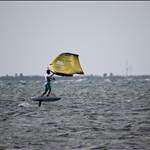
Foil with 6.6 still needs 13 to get up and going....slowly.
What makes foiling so much fun.!!
Yesterday arvo there was no swell and it was blowing 15-20knts wsw so pretty crappy and onshore and crap for wave sailing slappa style..
So instead I was Fully powered up on 4m wave sail/ Infinity76 foil combo. 1.5hrs and 34kms later.
Spent the whole time on foil carving and gybing. Long upwind runs then surfing/ carving the small wind waves back downhill
Hi Bender, what Garmin app do you use on your watch for those nice tracking maps etc?
I just got myself a Garmin watch and hoped to be able to overlay the windfoil track onto a map as you just made here!
But its quite a new world to me, so not aware of all required to get that to work.
I can see that there is an app called "windsurfing" in the Garmin app store, but not aware of what that entails...
Or if alternative better apps exists.
Thx for any help on this!
You actually do not need any app to get GPS tracks onto a map or satellite picture. You can use the file manager of any Windows or Mac or Linux computer to simply download the GPS file from the watch. For the Garmin it is a .FIT file. Many watches uses .FIT, but some use .GPX or .NMEA . Of course, you first had to connect the watch to computer with a usb cable and let the OS find and install the driver.
You can then upload the GPS file directly file into Strava or Endomondo or any number of other sites out there to see your GPS track on a map. If you then need to share the GPS track using a more universal file format than .FIT, they all can convert and download the .FIT to .GPX.
I record all my sessions with a cheap Timex GPS watch and upload to Strava for archiving.
Thank you segler,
That sounds pretty straight forward then!
But guess that i do need somehow then to activate the GPX function then on my Garmin watch?
Dont think that is activated by default, as think it would consume the battery power more quickly if on 24/7?
Sorry, i expected Bender also to use a Garmin watch, as the screenshot he posted with the map and his windfoiling tracks overlay appeared to be from the Garmin website?
Sorry for all the many questions!
Haven't foiled in the past 2 weeks. Just windsurfed on 4.2 to 5.5's well powered and mostly 80-100 liter boards.
The 600 sq cm foil works just like the 1220 when it's windy.