Weather | Buy&Sell | Forums |  |
Weather | Buy & Sell | Gallery | Forums | |
hi john,
it's hard to tell as the mid range model I trust most (ecmwf) is only starting to come into it's prediction window. it really is in the too hard basket. it looks like the dominant pattern is east coast troughing.
it all depends on how strong and the timing of the movement of highs down south (ridging) as to the location of the troughs that move from west to east.
east coast troughs usually produce S/SE winds for us and are associated with a following front. the problem with computer models and east coast troughs is the models tend to swing wildly and vary their forecasts each day because troughs/fronts are unpredictable and can contain lows that spring up out of nowhere.
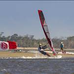
this is a typical weather pattern for qld through spring/summer. from memory the 2009 event had similar conditions as did other years where we got good fronts during the event. other years it's been the monsoonal trough that's dominated producing lows in the coral sea.
the current timing of the MJO suggest that the monsoonal trough will stay quiet until towards the end of the event and into early april which at that time you would expect the SE trades to become more predictable.
agree Jason,
and if crossing fingers doesn't work there is always the fishing, supping, boating, eating, drinking and lazing by the pool to enjoy.
that said, It would be a very rare instance where no windsurfing occurred during the event. ![]()
we can do it over on burrum point, it's the perfect place.....
umm.... I mean. oh no that's not a good thing to do..... ![]()
I just got off the phone with brooke at burrum sands. burrum sands is speed HQ.
she said it's been blowing consistently for the last 2 weeks. that every day the forecast is for light conditions so they go boating, then the wind fills in just prior to lunch and blows much stronger than the forecasts. they've been getting northerlies. greg the skipper from the barge said a few weeks back the same thing to me.
she also said,
the water is crystal clear
there are no jelly fish
there is no seaweed
and it hasn't rained in months so the weather has been very good.
very loose forecast update.
yes I know, don't mention the wind.
anything is still possible including no wind at all but here is how the models are playing out with 1 week to go.
gfs model has a weak trough over qld pushing against the high down south resulting in 15-20 knots of ESE-SE winds from 26th - 29th and the monsoonal trough strengthening from 29th onwards so the highs south of us ramp up 20-25 knots SE
ecmwf has the trough more in play and the high (ridge) down south strengthening as it moves toward NZ where it gets to around 1030 hpa and blows E winds onto the East coast. this particular setup usually produces NE seabreezes in QLD and ecmwf is shooting for 20-25 knot ENE-NE winds from Wednesday 26th - 29th which is the extent of the model run.
no doubt things will change again so i'll leave the forecasting on that very positive and currently fictitious note, cross fingers, toes and feet and remind myself to take the sup just in case.
trophies look awesome kellie! hand crafted especially for the event.
your dad and you did a fantastic job.
we also have the trophies for the one design state titles ad the longboards coming up to us this week.
Hey, little gold statue man is doing a forward, or is he ..., no not catapulting? ![]()
you're right there dave, it's the setup stance. :-)
I haven't seen the entry list as yet so are we going to drag you up there? be good to catch up again but understand if home commitments are pressing.
cheers dave,
will be trying a little harder this year to get stuff online at the end of the day. we've had issues previously because the phone coverage at burrum is fairly sad.
burrum sands have offered to let us use their network at this years event.
Which weather graph on Seabreaze will be the best to observe wind conditions at Burrum?
or better to use Windguru for this spot ?
www.windguru.cz/117767

for real time reports I usually look at hervey bay and suggest that the wind won't be any lighter than shown there. primarily because the burrum run is out from the land so has nothing disrupting the wind.
you could also look at central coast info on seabreeze because Bundaberg is listed there and that's only a little bit further north.
if you are chasing forecasts then there are 3 main models used.
gfs which is bsch, wind guru. if you hang out in the wether forums you'll quickly hear bad words spoken of gfs. for me it's hit and miss.
ecmwf which is the bom marine forecast plus seabreeze. I like ecmwf as I find it fairly accurate.
then there are the boms own model based, primarily based on the ecmwf model. there are a few options there. access-g, access-t and access-r
the one I have found the most success with is the bom marine model. it uses the ecmwf and then switches to the bom model with 2 days to go.
www.bom.gov.au/marine/wind.shtml
the boms access-g model I'm not really that familiar with. it should be the best so I should probably start using it.
www.weatherzone.com.au/models/?lt=wzcountry&lc=aus&mt=accessg&mso=0&mc=sfcwinds&focus=mc
this site also allows you to load up both gfs or ecmwf via the model data tab on the control panel on the right hand side. then you can change dates and times at the bottom left.
www.wunderground.com/wundermap/?zoom=4&rad=0&wxsn=0&svr=0&cams=0&sat=0&riv=0&mm=1&mm.mdl=GFS&mm.type=SURPRE&mm.hour=0&mm.opa=100&mm.clk=0&hur=0&fire=0&tor=0&ndfd=0&pix=0&dir=0&ads=0&tfk=0&fodors=0&ski=0&ls=0&rad2=0
are you going off the forecast to figure out whether to go or not?
From yesterday's Sunshine Coast Daily, apologies to Dennis Winstanley he has actually won the Windsurfer One Design class 19 times!,

Hey Justin, is there a pub at Burrum Heads ? If I come up I may need somewhere to hang out at night time just in case I get kicked out of the 24 hour a day Party at Hoorays house....![]()
there is the burrum heads hotel.
I'm sure there will be many a room available around town if needed. i'll most likely have a spare spot at some point as well.
Just got in to Port Macquarrie, should arrive at Burrum Wed am.
Have I made a mistake not packing my 4m Koncept??? ![]()