Weather | Buy&Sell | Forums |  |
Weather | Buy & Sell | Gallery | Forums | |
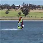
I have just had three very enjoyable days of sailing at LG with PG and Jimbob, and it was really nice. I took a few photos so I thought I should share my observations on the condition of the Lake.
For those who were there is 2015, I doubt you would recognise it as the same place. The water is still up to the road and the 5 Mile rigging area is a mess:

From the watermark, I'd say this area was about 1 meter under water!


The area just close off this spot is a clay bottom and is the only place I saw where the water is still a bit milky. everywhere else it is crystal clear and you can see the weed or the bottom of the lake as you sail. In this water level is is a terrible launching spot.
The Top Lake still has some shallow water in it, so driving around to Cockies is not on:


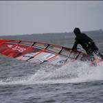
Here are some shots from just a few hundred meters East of the 5 mile where the bottom is Sandy and firm, the water crystal clear and the weed really thick. Also, it is deep enough to sail about 50 meters out with a 27cm fin.


Oh yes, and the water is really choppy! ![]()

Half way in between at the turning circle - I think this sign would have been under water at the peak!:

Clear water:

Lots of weed where Jamie says it was blowing sand a year ago!

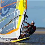
Some lake views:


I had three days of great SE wind. the second day (Wednesday) had the strongest, when it got up to around 25 knots with short gusts to maybe high 20's. Even in the middle of the lake near the monitoring station, the waves were only about 20-30 cm, and there was only less than 10cm wavelets on the edges and between the islands. In the areas of the lake where it was chest deep, the weed growth was within 20-30cm of the surface. I was amazed at how much it has grown. A lot of it was .5m to 1m long, or more, from the bottom and really thick. Up the top of the lake (South East - closer to Beachport), where it was pretty much dry in 2013-2015, it was half a meter deep and weed almost to the surface.
Wednesdays Trackmap (Wind 20-25kts):

Thursdays Trackmap (wind 13-18 knots)

Unfortunately, this was not a good year for the good SE winds at LG. They were not at all as prolific as in the 2013-2015 seasons in January and February. The 3 days of SE wind this week were nice but not really the thermal winds of summer. Not as steady and consistent, and not as strong.
It is shaping up to have great conditions next summer. If the weather returns to it's more normal pattern and the Lake levels recede in the usual fashion, it may even be EPIC! ![]()
But even as it is now, with the right winds, it is better fun sailing than you will find almost anywhere. ![]()
Thanks for the update Daffy,looks like you covered every inch of the middle lake,magic place, might sneak a sail in when a strong winter front comes through.
I sailed Robe 3rd ramp and cracked my big wave board when I got dumped 2 hours into my holiday. So, I decided to head to LG for the remainder. Wave gear on a lake is no fun and wish I have packed some slalom kit. I wanted to sail mostly ocean this visit, but as you said, the ON/OFF gusts were insane and the ocean conditions weren't what I imagined.
I sailed with old Rod at the 3 mile on Wednesday and then Woakwine Cutting Rd the next day. I think you came over and waved me at one stage. I would have joined you all at the split, but the wave gear doesn't point that good and I didn't want to get stuck. The water was dead flat at Woakwine, but not as good as Stansbury ![]()
Yes, that was me jn. ![]()
I thought it looked pretty nice over near the Woakwine, but the wind seemed a bit softer over that way Wednesday, so I came back.
Regarding the Lake George Department of Environment, Water and Natural Resources (DEWNR) water monitoring stations.
I wrote to the department about 18 months ago enquiring about the status and maintenance of the Lake George Monitoring stations. At the time I was informed that they were aware that the stations had outages and were waiting for water levels to rise so a boat could be launched to assess them.
Since the big flooding event last year I wrote again to enquire if they had been able to check them now water levels were up.
I got a reply from a new officer in the region who said there had recently been some retirements and re-allocation of staff in the area. He had just taken over the area responsibility, was investigating, and would report what he discovered.
I explained to him that we have a community of interested windsurfers users of the Lake who had a vital interest in the data on water levels, salinity, turbidity and wind velocity being available, and when conditions are good, the lake is visited by large numbers of these windsurfers, from all over Australia, and even overseas, over the summer months, bringing substantial benefits to the local businesses and community.
He has just reported back to me that they were able to get on the Lake and check both stations last week. He said that at the beginning of 2013, there were over 70 telemetered monitoring stations installed all over the south-east, including those in Lake George. Due to staffing and budget cuts in mid-2013, some tough decisions had to be made as to which stations would maintained to the highest standards (less than 20), which would be closed (another 20 or so), and which would left running and then closed once they failed. He thought that the Lake George sites were considered too difficult to access and so were not considered a high priority.
Various recent staff changes mean that they are having another look at the entire network.
"Knowing that people are actually using the data from any given station lifts its profile and gives it a chance of being in the 'maintain to highest standards' group; public funds should benefit the public. Having said that, these two sites obviously are not the simplest ones to get to, so that will be taken into consideration when it comes to a decision about their future. You certainly have helped their cause by highlighting how important that data is to your community."
He said that there will shortly be discussions about the future of these sites, which will determine if/when they get back out there. He thinks these sites have proven problematic in the past, but maybe with a sharper focus on what we want to measure out there, they could be made more reliable and useful to the community.
He has promised to keep us informed about what happens and what they decide.
The current status from last weeks inspection:
The Big Lake site that is still running but has lost it's water level sensor. It has broken free of one of it's four anchors and they were not able to land on it for closer inspection due to rough water. The level sensor issue may be related to the anchor problem.
They will try again when conditions are calm.
The Middle Lake station had a mechanical failure which caused the solar panels to become disconnected, as well as allowing water to get in to the 'waterproof' enclosure. They don't hold high hopes for rescuing any of that equipment, and they didn't have all of the parts necessary to get it up and running again as these are not standard sites. He said he will be able to put something together, but just not sure when due to other competing priorities at the moment.
I told him that if it became a choice, we would probably prefer efforts to be focused on the Middle Lake Station.
I also raised the possibility of our community helping out in some way if we could.
I will report back when I hear more.
For those who don't already know, below are the links to the system of water monitoring stations. There is not much of interest to see on the Lake George stations at the moment apart from the Historic data plots.
This is the home page for the SA water monitoring stations:
www.waterconnect.sa.gov.au/Systems/RTWD/Pages/Default.aspx
This link should take you to the Middle Lake station data:
www.waterconnect.sa.gov.au/Systems/SiteInfo/Pages/Default.aspx?site=A2391078&period=HRLY#Historic%20Data
This should take you to the Big Lake data:
www.waterconnect.sa.gov.au/Systems/SiteInfo/Pages/Default.aspx?site=A2391077&period=HRLY#Site%20Summary
One of the useful things about the Middle Lake station, when it was in full operation, was the Anemometer real time plot. It was in KM/hr and the scale seemed to be way off, but once correlated with known previous conditions, it was a very useful guide to wind conditions. In fact, the readings in KM/hr were roughly close to the real speed in Knots when it was last operating.
The two most useful readings for us were obviously the water level and the wind strength and direction readings, but it is very nice to know the salinity and turbidity levels, especially in a historical plot context, to get a gauge of overall lake condition.
Four of us Breakaways spent a week at LG in Feb this year, had a great time. Sailed 4 days not in the usual SE conditions but fronts which were still heaps of fun. Too much water to get to Cockies so launched at Packin Point. Water was clear as and you can see the weed growing. As per Daffy's predictions it should be sweet by summer, fingers crossed.
Its always a fun time anyway, sailing, mountain bike riding, chilling and meals at Beachport pub.
Any update on water levels and weed growth would be appreciated Jimbob if you see this. ![]()
Ok daffy ![]()
 Bloody phone always puts pictures sideways !!!!
This was a month ago but did see this sign right under before that,, spit still went right under. opened to the sea at 500 meters above sea level on middle station reading and still opened and running out.
 Last week has already dropped a good foot since long week end, actually foiled of the spit a few weeks ago but maybe pushing it now, still a couple yachts moored at 5mile.
Can nearly drive into Packers point at 3mile camp.
5 mile drift track still under.
Weed looks like it was end of last summer in daffys pics,
just starting to get some small sea breeze late in the day.
What are the months that it blows enough to sail?
I might be driving back to WA in April next yr, should i take my kit with me when i drive over so i can use it on the way back?
I may also try to sneak a session in on the way over if the family allow me. The will be flying home so i can take my time, sort of.
Many thanks for the update Jimbob! ![]()
From what I have seen, the favoured SE High Pressure induced winds seem to start showing up occasionally around Christmas, maybe a bit earlier sometimes, and get stronger and more reliable Mid January through February and start to peter out early March. But there can be a few days of good SE winds either side of that if the High pressure passes in the right place.
It can be very windy when WSW fronts pass and often with NW winds before they arrive. If the water levels and weed conditions are good, they might be sailable, but they are not the favoured conditions.
Does that sound about right Jimbob?
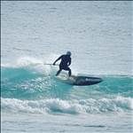
I had a fun trip in 21-23 March this year with a few days of nice wind. Some pics with the posts:
gpsteamchallenge.com.au/sailor_session/show?date=2017-03-21&team=16
gpsteamchallenge.com.au/sailor_session/show?date=2017-03-22&team=16
gpsteamchallenge.com.au/sailor_session/show?date=2017-03-23&team=16
It's possible to look up historic records of Windguru forecasts which can be quite interesting. ![]()
Yep.. scored a great session at end of march one year... spoiled by having to share the lake with Firiebob! ![]()
www.gpsteamchallenge.com.au/sailor_session/show?date=2014-03-25&team=29


The outlet was being closed yesterday the last middle bit will be done next week.
That looks a helluva lot different than when we were there in Feb this year, wow!!!!!!!!!!!!
So how is Lake George looking for Jan/Feb/Mar 2018, I need to start planning a trip over from the east coast if it looks like the conditions are going to be good.
I'll be driving past going east at the end of march then past again end of April. If it's windy my family wil suffer.
Is it likely to be windy those times?
The preferred nice SE winds are usually (but not always entirely) starting to switch off in mid March. But it can be great on almost any wind direction if the other conditions of level and weed are good. I would say, if there looks like being some wind forecast you should definitly have a look. ![]()